
Being perched off the northwest edge of Europe means that people in the UK are not often reminded of the vast Sahara desert situated only a few thousand miles to the south.
This great desert is located under a descending branch of the global atmospheric circulation, that is, a point at which air, having been heated close to the equator and then blown north or southwards high in the atmosphere, then descends back to the surface. This leads to a hot, dry climate in the Sahara with little vegetation.
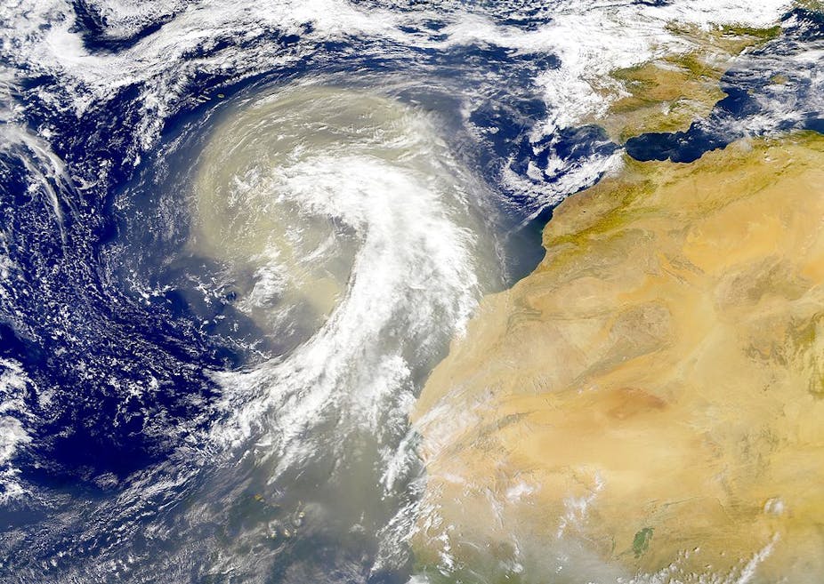
Strong winds can lift dust from the bare desert soils, which can then be carried by the wind for thousands of kilometres. This dust is in fact a natural part of the earth system, providing essential nutrients to plankton in the oceans and plants growing as far away as the Amazon.
Particularly large and intense dust storms occur quite often over the Sahara in spring, as weather fronts trailing from mid-latitude weather systems over the northern part of the Sahara generate winds strong enough to lift up the sands. It’s more unusual that dust from the Sahara is transported directly to the UK, but when it does, rain can bring the dust back down to earth.
This is often seen as a thin film of dust on cars, as noted in southern England. In Africa, persistently high concentrations of atmospheric dust have been linked to meningitis outbreaks, but the low concentrations that reach the UK are not a hazard. But in recent days the southerly winds bringing the dust have also brought man-made pollution from continental Europe. Trapped close to ground level and combined with pollutants from the UK, particularly emissions from road traffic in and around London, this has led to unusually high levels of air pollution.
Saharan dust storms can be seen from space, because the dust reflects solar radiation and absorbs and emits infrared. This means atmospheric dust can either cool or warm the atmosphere, depending on its properties and those of the underlying surface. This interaction affects the rate at which the sun warms the earth’s surface, and how quickly earth loses that heat to space.
This means that weather forecast centres (such as the Met Office and the European Centre for Medium-Range Weather Forecasts) are increasingly accounting for the effects of the varied atmospheric dust loads in their forecasting systems. This has led to improved forecasts not only for Africa, but also other regions such as Europe.
Further chemistry takes place in clouds: the dust seen in the UK was brought down by rain, most of which would have originated from ice and snow in clouds. The dust is not only transported in such clouds, but interacts with them. In particular, the presence of dust allows ice crystals to form at warmer temperatures than would otherwise be the case (in the atmosphere, at temperatures warmer than about -38°C, some kind of solid nucleus is needed around which ice can form).
The Sahara has not always been a desert, and sediments from ancient lakes are one source of fine particles that, once uplifted by strong winds, then fall sufficiently slowly to be transported over large distances. The winds do not lift these particles directly; instead they lift larger particles which quickly fall back to the surface, in turn releasing smaller particles on impact (a process called saltation).
As well as cold fronts from cyclones, a variety of meteorological mechanisms can lead to strong winds and so dust uplift. Understanding these mechanisms and improving dust forecasts is an area of active research.