

One of the worst instances of mangrove forest dieback ever recorded globally struck Australia’s Gulf of Carpentaria in the summer of 2015-16. A combination of extreme temperatures, drought and lowered sea levels likely caused this dieback, according to our investigation published in the journal Marine and Freshwater Research.
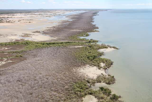
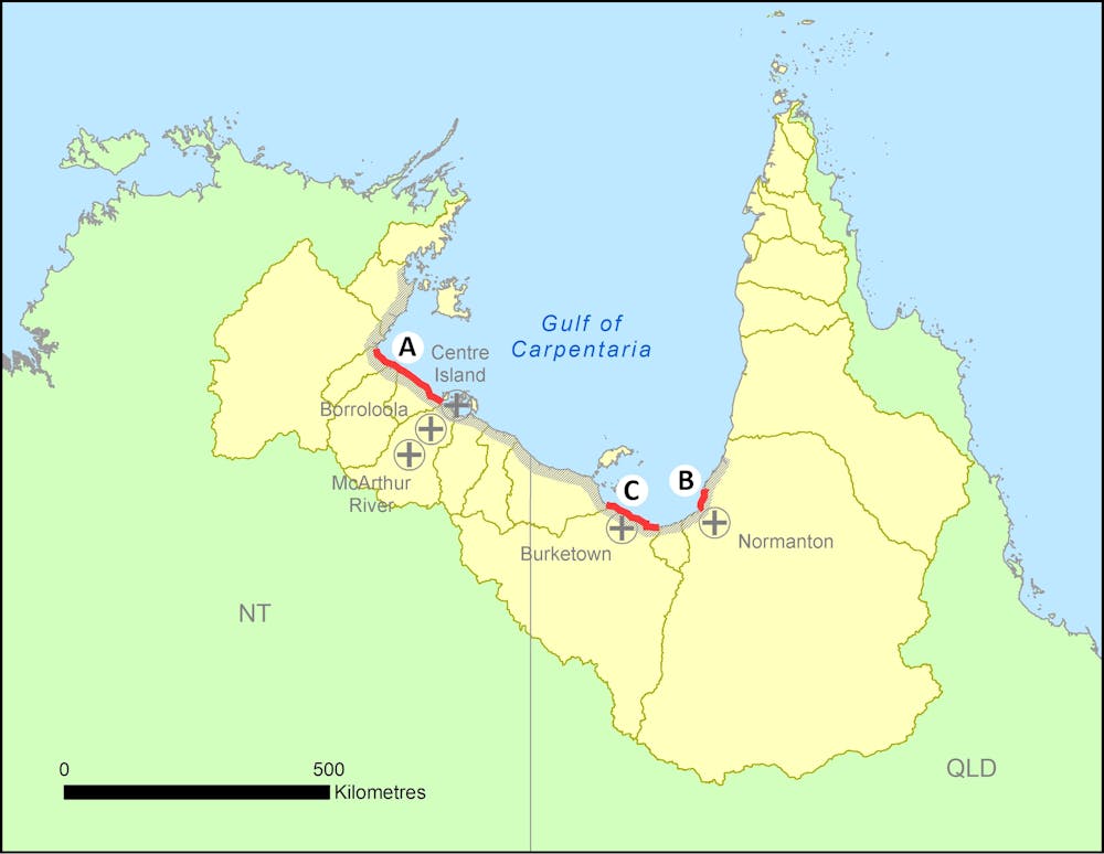
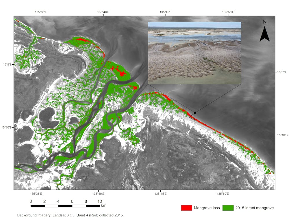
The dieback, which coincided with the Great Barrier Reef’s worst ever bleaching event, affected 1,000km of coastline between the Roper River in the Northern Territory and Karumba in Queensland.
About 7,400 hectares, or 6%, of the gulf’s mangrove forest had died. Losses were most severe in the NT, where around 5,500ha of mangroves suffered dieback. Some of the gulf’s many catchments, such as the Robinson and McArthur rivers, lost up to 26% of their mangroves.
The gulf, a remote but valuable place
The Gulf of Carpentaria is a continuous sweep of wide tidal wetlands fringed by mangroves, meandering estuaries, creeks and beaches. Its size and naturalness makes it globally exceptional.
An apron of broad mudflats and seagrass meadows supports thousands of marine turtles and dugongs. A thriving fishing industry worth at least A$30 million ultimately depends on mangroves.
Mangroves and saltmarsh plants are uniquely adapted to extreme and fickle coastal shoreline ecosystems. They normally cope with salt and daily inundation, having evolved specialised physiological and morphological traits, such as salt excretion and unique breathing roots.
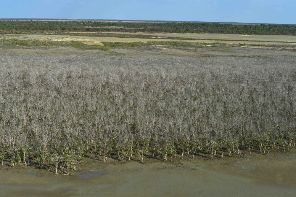
But in early 2016, local tour operators and consultants doing bird surveys alerted authorities to mangroves dying en masse along entire shorelines. They reported skeletonised mangroves over several hundred kilometres, with the trees appearing to have died simultaneously. They sent photos and even tracked down satellite images to confirm their concerns. The NT government supported the first investigative surveys in June 2016.
In the end, the emails from citizen scientists nailed the timing: “looks like it started maybe December 2015”; the severity: “I’ve seen dieback before, but not like this”; and the cause: “guessing it may be the consequence of the four-year drought”.
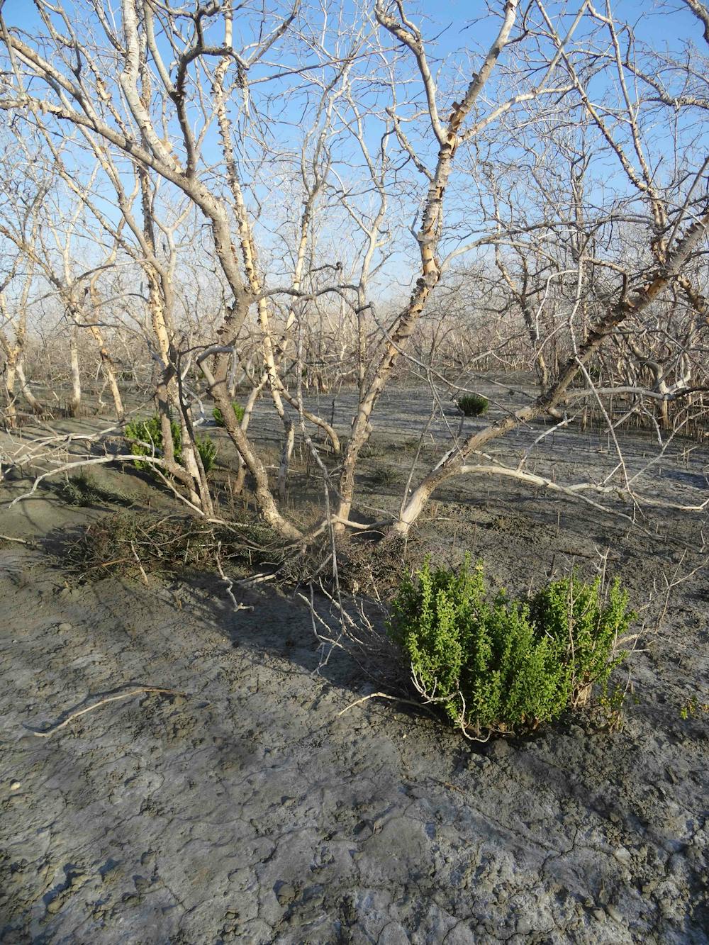
Our investigation used satellite imagery dating back to 1972 to confirm that the dieback was an unparalleled event. Further aerial helicopter surveys and mapping during 2016, after the dieback, validated the severity of the event extending across the entire gulf. Mangrove dieback has been recorded in Australia in the past but over decades, not months.
Mysterious patterns in the dieback
We still don’t fully understand what caused the dieback. But we can rule out the usual suspects of chemical or oil spills, or severe storm events. It was also significant that losses occurred simultaneously across a 1,000km front.
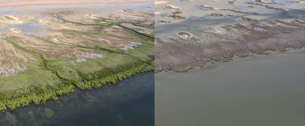
There were also a number of tell-tale patterns in the dieback. The worst-impacted locations had more or less complete loss of shoreline-fringing mangroves. This mirrored a general loss of mangroves fringing tidal saltpans and saltmarshes along this semi-arid coast.
Mangroves were unaffected where they kept their feet wet along estuaries and rivers. This, as well as the timing and severity of the event, points to a connection with extreme weather and climate patterns, and particularly the month-long drop of 20cm in local sea levels.
Extreme weather the likely culprit
We believe the dieback is best explained by drought, hot water, hot air and the temporary drop in sea level. Each of these was correlated with the strong 2015-16 El Niño. Let’s take a look at each in turn.
First, the dieback happened at the end of an unusually long period of severe drought conditions, which prevailed for much of 2015 following four years of below-average rainfall. This caused severe moisture stress in mangroves growing alongside saltmarsh and saltpans.
Second, the dieback coincided with hot sea temperatures that also caused coral bleaching along the Great Barrier Reef. While mangroves are known to be relatively heat-tolerant, they have their limits.
The air temperatures recorded at the time of the mangrove dieback, particularly from February to September 2015, were also exceptionally high.
Third, the sea level dropped by up to 20cm at the time of the dieback when the mangroves were both heat- and moisture-stressed. Sea levels commonly drop in the western Pacific (and rise in the eastern Pacific) during strong El Niño years: and the 2015-2016 El Niño was the third-strongest recorded.
The mangroves appear to have died of thirst. Mangroves may be hardy plants, but when sea levels drop, reducing inundation, coupled with already heat-and-drought-stressed weather conditions, then the plants will die – much like your neglected pot plants.
We don’t yet know what role human-caused climate change played in these particular weather events or El Niño. But the unprecedented extent of the dieback, the confluence of extreme climate events and the coincidence with the bleaching of the Great Barrier Reef mean the role of climate change will be of critical interest in the global response to mangrove decline.
What future for mangroves?
The future for mangroves around the world is mixed. Thanks to climate change, droughts are expected to become hotter and more frequent. If the gulf’s mangroves experience further dieback in the future, this will have serious implications for Australia’s northern fisheries including the iconic prawn fishery, mudcrab and fin fish fisheries. All species are closely associated with healthy mangroves.
We don’t know whether the mangroves will recover or not. But there is now a further risk of shoreline erosion and retreat, particularly if the region is struck by a cyclone – and this may have already begun with recent cyclonic weather and flooding in the gulf. The movement of mangrove sediments will lead to massive releases of carbon uniquely buried among their roots.
Mangroves are among the most carbon-rich forests in the tropics and semi-tropics and much of this carbon could enter the atmosphere.
Now we urgently need to understand how mangroves died at large and smaller scales (such as river catchments), so we can develop strategies to help them adapt to future change.
Australia’s top specialists and managers will be reviewing the current situation at a dedicated workshop during next week’s Australian Mangrove and Saltmarsh Network annual conference in Hobart.