
Has a United Nations international boundary committee really “sided with Argentina” by expanding its maritime limits in the South Atlantic by a third to include the disputed Falkland Islands, or Islas Malvinas, as has been widely reported?
In fact, the announcement from a subcommittee of the Commission on the Limits of the Continental Shelf (CLCS) does no such thing. The CLCS was established by the 1982 United Nations Convention on the Law of the Sea to do one thing: verify the scientific data that a state submits to determine the limits of its outer continental shelf, and therefore the extent of the area to which it has exclusive access to seabed resources.
A state’s exclusive economic zone (EEZ) runs from 12-200 nautical miles from shore, and beyond that lies the outer continental shelf, extending as far as 350 nautical miles or potentially even further. Because the scientific basis for making such claims is highly technical, the UN established the CLCS to assess states’ submissions. Right from the beginning it was recognised that in many cases states’ claims could legitimately overlap.
Claim and counter-claim
For instance, imagine a situation where Country A and Country B are 500 nautical miles apart from each other. Country A makes a submission proposing that there is a contiguous seabed that goes all the way to Country B. In such a case, the 200 nautical miles closest to Country A would clearly be part of Country A’s EEZ, the 200 nautical miles closest to Country B would clearly be part of Country B’s EEZ, and the 100 nautical miles in the middle would seemingly be awarded to Country A.
However, while disputes over territory on land or in territorial waters near the coast are zero-sum games – where one country’s gain is necessarily another’s loss – in this case the science that supports the geological contiguity of the seabed backing Country A’s claim is very likely to also support the same claims made by Country B.
This is acknowledged under the Law of the Sea through separating the verification of the science from the actual drawing of boundaries. Having certified the scientific basis for any claims, the CLCS turns the matter to arbitration or to a tribunal that then can divide up the shared space between the states with legitimate claims to it. Often this involves just drawing a line down the middle. However, that line may be adjusted – due to differences in the competing states’ populations or historic factors, for example. Or the two states may decide to administer their overlapping seabeds jointly and share resource revenues equitably.
Share and share alike: it works in the Arctic
Despite popular conceptions of an ongoing rush for Arctic territory, states with competing claims have recognised their shared interest in establishing scientific data universally agreed by all. So although Canada, Denmark, Russia, and the US are all ultimately competitors for what lies beneath the seabed of the Arctic Ocean, they generally recognise that acknowledgement of each state’s claim – including their own – is dependent on universal recognition of scientific data. They have therefore been working closely together to map the ocean floor, sharing costs, exchanging specialised expertise and equipment, and uploading data to an openly accessible website: the International Bathymetric Chart of the Arctic Ocean.
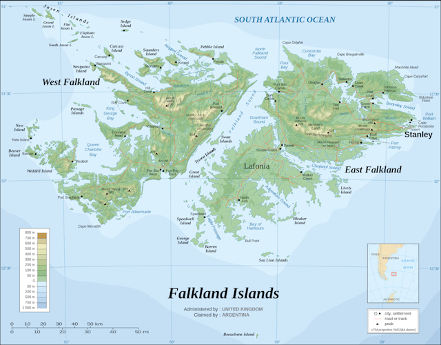
A similar situation could exist in the South Atlantic, but for the long-running dispute between Argentina and the United Kingdom over the Falkland/Malvinas Islands which has at times broken into open military conflict, most recently during the Falklands War of 1982. There is no equivalent dispute over land, rather than ocean, territory among the Arctic nations.
No end in sight yet
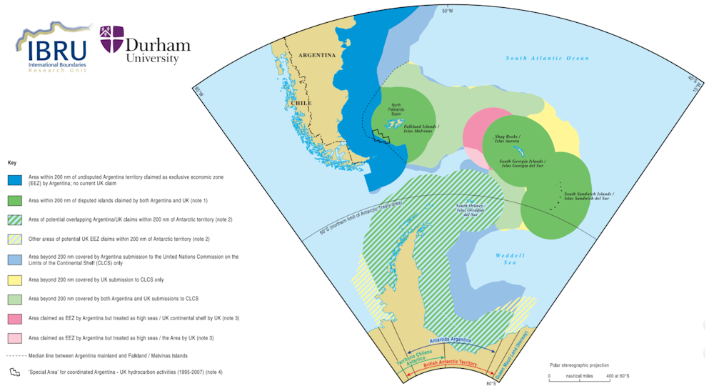
Well aware of the dispute, the CLCS has moved carefully in the South Atlantic. In 2009 the UK and Argentina both made submissions to the CLCS with significant overlap, as demonstrated by this map produced by IBRU, the Centre for Borders Research at Durham University.
This is a case where shared scientific research could support both sides’ claims. When the CLCS empowered a subcommittee to make a preliminary determination on Argentina’s claims in 2012 it noted that a final determination could not be made until the Falkland/Malvinas sovereignty dispute was settled. So even while this subcommittee has now endorsed Argentina’s science, and regardless of the fact that it’s been promoted as a “win” for the Argentine government (and, by implication, a “loss” for the UK), it doesn’t, in fact, move the process forward. There can be no progress until the sovereignty issue is settled.
Indeed, the CLCS finding that Argentina’s science is sound is also likely to strengthen the UK’s claim to the contested seabed around the islands. Should the UK’s claim to the islands be recognised, the CLCS finding makes it more likely than ever that the seabed between the islands and the Argentine mainland will need to be shared.
In the long run the UK and Argentina will have to move toward finding a shared interest – perhaps even the two states can achieve détente through science (and the hope of a share of the region’s oil and mineral wealth). Unfortunately in the short term the ruling has invoked only passions and political posturing that does nothing to move towards a solution for the South Atlantic.