Cartography has become one of the most successful technologies for understanding the world around us. But like the world itself, maps and map-making are constantly evolving.
Maps contain useful information, but that means leaving out other information that is also useful.
Associated Press
Boundaries aren’t just treaties. They’ve been built from rivers, oral history and newspaper notices — and rocks in the way of farmers.
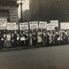
An early 20th-century NAACP map showing lynchings between 1909 and 1918. The maps were sent to politicians and newspapers in an effort to spur legislation protecting Black Americans.
Library of Congress
Counties, local authorities, councils – how you divvy up the map changes the game significantly.
Tharp with an undersea map at her desk. Rolled sonar profiles of the ocean floor are on the shelf behind her.
Lamont-Doherty Earth Observatory and the estate of Marie Tharp
Born on July 30, 1920, geologist and cartographer Tharp changed scientific thinking about what lay at the bottom of the ocean – not a featureless flat, but rugged and varied terrain.
In May 2019, Canada made a partial submission to the United Nations on the limits of its extended continental shelf in the Arctic.
Maps can be a tool in the defense of Indigenous communities against extractive industries.
Canadian Centre for Architecture; Grant Tigner, painter. Seagrams Limited, publisher. The St. Lawrence Seaway and Power Project, in The St. Lawrence Seaway: The Realization of a Mighty Dream, 1954.
Historically, western corporate maps have been privileged over Indigenous ones. But given the essential debate of territory in resource conflicts, maps are a crucial tool.
Economists try to create and use maps to navigate the world of human choices. But in some ways, these maps are limited.
“The earth is our mother. We should look after and respect her. This territory is where the peccary passed. Under the authority of Karodaybi [the first Munduruku warrior]
Mauricio Torres