

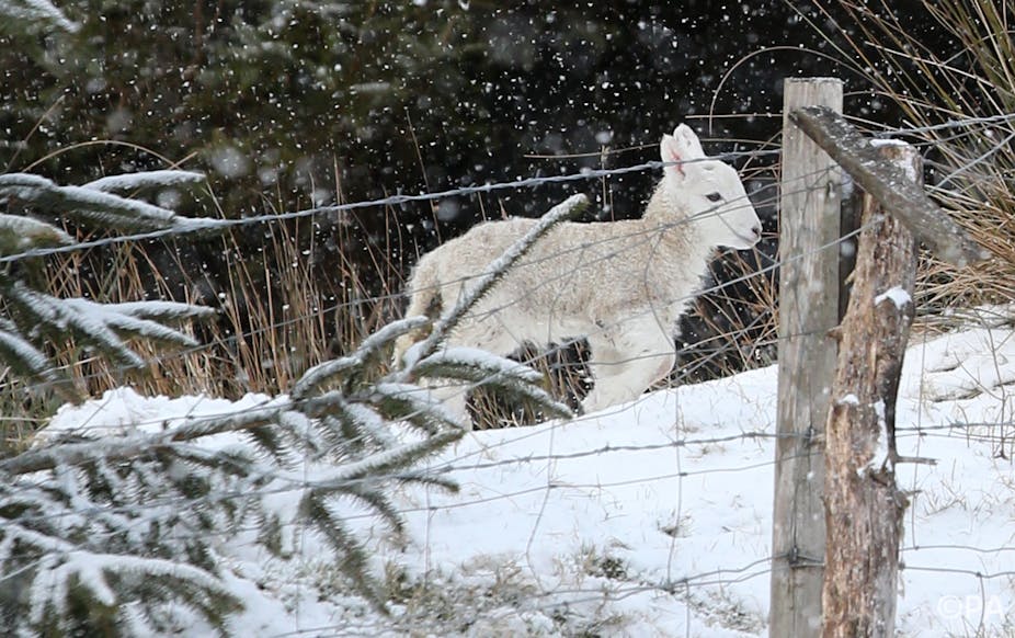
If you are one of the many people with a larger than normal heating bill for recent months, you would probably be under the impression that it has been exceptionally cold in the northern hemisphere. We’ve experienced heavy snow on multiple occasions in the UK and seen images in the news of similarly frigid conditions in parts of mainland Europe and the United States.
In fact, some places experienced cold conditions, while other places experienced warmth that was anomalous for the time of year. These events were driven by unusual atmospheric circulation, which redistributed typical weather patterns across the northern hemisphere.
Warm, with pockets of cold
While some places were cold, the northern hemisphere was warmer than average in March, and indeed across the winter, consistent with long-term warming trends. The US National Climatic Data Centre (NCDC) has recently described such conditions as “pockets of cold in a warming world”.
The last time the northern hemisphere recorded a month — any month — that was cooler than the 1961-1990 long-term average was in February 1994. The last time a whole northern hemisphere winter was colder than average was 1984.
Cold weather still happens — but it is less frequent, and most often less cold, than it was during most of the 20th century.
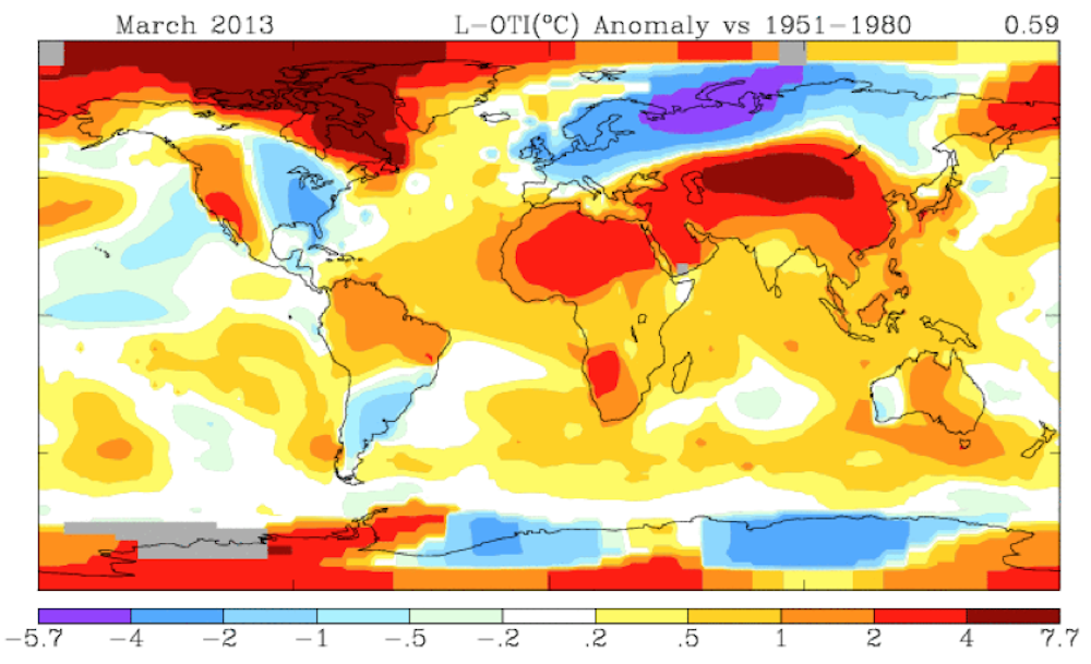
The month of March has been locally reported as being intensely cold in the northern hemisphere. But when averaged over the globe or the hemispheres, March 2013 was actually notable for its warmth. Globally, temperatures were 0.46°C above the 1961-1990 average, almost exactly matching average values of the last decade, and it was the tenth-warmest March on record for both the northern and southern hemispheres. In the northern hemisphere, it was a spring of extremes in particular places. But overall the warm regions more than cancelled out the cold regions, as the hemispheric average shows.
What happened in March 2013?
The major influence on the extreme conditions — both warm and cold — in March in the northern hemisphere was a highly abnormal air pressure pattern.
Under normal circumstances, winter sees high pressure systems sitting over subtropical latitudes and low pressure at higher latitudes (the “Azores high” and “Icelandic low”). The westerly winds between those two systems — the north Atlantic “storm track” — direct relatively mild maritime air over Europe, making its winters much warmer than those of most other places at the same latitude.
For example, the average winter temperature in Paris is more than 10°C warmer than Montreal, and 25°C warmer than Harbin in northeastern China, despite Paris being further north than these cities.
In March 2013 this situation was reversed, with persistent high pressure over the Arctic and sub-Arctic, and low pressure in the central Atlantic. Monthly averaged air pressure was well above normal near and north of Iceland, and well below normal west of Portugal.
This also reversed the usual airflow, directing easterly winds over northern and central Europe — which brought cold air, originating over Russia, across the continent.
Weather in the northern hemisphere
The result of the unusual pressure pattern was an extremely cold month in northern and central Europe. Monthly average temperatures were 5-7°C below normal in western Russia, much of Finland and the Baltic countries, and parts of Germany and Poland, and at least 3°C below normal over most remaining parts of the region.
March in the UK was the coldest since 1962 (and colder than any winter month between 1997 and 2009), and Germany had its fifth-coldest March since 1881. With the cold came unusual snowfalls in many regions, perhaps the most notable being falls of up to 25cm on the islands of Jersey and Guernsey on 11-12 March — an exceptional event for any time of year. Further south, temperatures were near normal, but under the influence of low pressure it was very wet. Large parts of Spain had their wettest March on record, with rainfall totals more than four times normal.
It was also a rather cold month in the eastern and central United States and adjacent parts of Canada, generally ranking between the 5th and 20th coldest of the last p00 years, although warm conditions in the west meant that the overall American average for the month came in at 0.5°C below normal. Notably, this followed another warmer than-average winter for the United States.
In the US, the month stood out for its contrast with the exceptionally warm March of 2012 — one example was in Chicago, where the maximum of −4°C on 20 March compared with a week of high 20s and low 30s at the same time last year.
In 2013, the contrast between cold air to the north and much warmer air further south has led to some wild fluctuations in temperature in some areas — one example being at Amarillo in west Texas, which had maximum temperatures of 32°C on 22 April and 2°C on the 23rd (even the cold fronts are bigger in Texas).
On the other side of the coin, it was much warmer than normal in many other parts of the northern hemisphere. Temperatures were well above average through most of central and eastern Asia outside of Russia, as well as in the northern half of Africa.
China had its second-warmest March on record, and monthly average temperatures were more than 7°C above normal in parts of Mongolia and eastern Kazakhstan. Large parts of the Arctic also experienced unusually high temperatures.
In the third week of March several days near 12°C, about 25°C above normal, occurred on the west coast of Greenland as far north as the Arctic Circle, and it was also much warmer (relatively speaking) than normal in much of the Canadian Arctic. Arctic sea-ice continued to be below average for March, following a record low at the end of the 2012 summer melt
As previously noted, and shown in the figure above, warmer than average conditions were more widespread across the Northern Hemisphere — and indeed the entire globe — during the month.
Is there a link to climate change?
One way of assessing how unusual the atmospheric conditions were in March is to make use of an index of atmospheric circulation, known as the Arctic Oscillation (AO) index.
This is an indicator of pressure patterns in the middle and high latitudes of the northern hemisphere. If pressure is above normal in the Arctic and below normal in the central North Atlantic and North Pacific, the AO index will be negative. It will be positive if the Azores high and Icelandic low are both stronger than normal.
The monthly average value of the Arctic Oscillation index for March was −3.18, meaning very-much-higher pressure over the Arctic and lower pressure further south.
This easily broke the previous record low for March, −2.82 in 1962, and was the sixth-lowest value on record for any month. Three of the six lowest monthly AO values on record have now occurred in the last four years, including the lowest of all, −4.27 in February 2010. You may recall that winter 2010 was exceptionally cold and snowy in the UK, much like March 2013.
As March 2013 has demonstrated, extreme phases of the Arctic Oscillation redistribute warmth from one region to another — and this is significant for seasonal weather.
In terms of climate change, there is no clear long-term trend in average values of the Arctic Oscillation index. However, a number of recent model-based studies have suggested a possible link between decreased Arctic Ocean sea-ice cover, driven by global warming, and extreme phases of the Arctic Oscillation.
This is still a new and active area of research, and it is too early to draw firm conclusions. The possibility will need to be monitored closely over the coming years.
This highlights a very interesting aspect of weather and climate at the poles, and particularly in the Arctic. Powerful “feedback mechanisms” operate in this part of the world — that can transiently accelerate or slow the pace of global warming. The prime example is the loss of Arctic sea-ice, which tends to accelerate the rate of warming in the Arctic Ocean.
Extreme weather in any given season in the Arctic — such as a record summer melt or particularly warm winter — can actually have lasting impacts in a climate system that is being changed by greenhouse warming.