

Five years ago, a magnitude 9.0 earthquake occurred 200km off the east coast of Japan, causing a devastating tsunami. The resulting waves affected 2,000km of coastline, killed some 18,000 people, destroyed nearly 110,000 buildings and damaged twice that number. It also triggered the meltdown at the Fukushima Daiichi nuclear power plant, which released toxic levels of radiation into the environment and remained the focus of worldwide concern for a long time afterwards.
As we reflect on the terrible destruction of lives and livelihoods wrought by this natural disaster, one question springs to mind: how can we better protect ourselves from the next one?
After all, this was not the first such disaster to hit Japan. For example, the 1896 and 1933 Sanriku earthquakes – which reached magnitudes of 8.5 and 8.4 respectively – also caused deadly tsunamis. For that reason, Japan had already introduced a number of defences prior to 2011. Tsunami barriers were constructed both on and offshore, trees were planted along the coastline, vertical evacuation buildings were built to the highest standards and regular evacuation training was introduced.
But the sheer force of the 2011 tsunami took many by surprise. Most of the protective measures were designed to cope with magnitude 7.4 to 8.0 earthquakes, which occur every few decades in the region. This planning failure was partly due to the limited amount of recorded data, which only spans back 40 to 50 years and contains uncertainties about the location and magnitude of previous mega-earthquakes.
To improve warning systems and build effective defences, we need a detailed understanding of how the tsunami gathers height as it nears the shoreline, and how this affects the damage caused. As soon as the major search and rescue operation was completed, the Tohoku Earthquake Tsunami Joint Survey Group – made up of natural scientists and engineers from 63 universities – set out to gather this information.
Damage is done
The group’s measurements confirmed that when the first wave hit the coast, it was largest at the point nearest to the earthquake’s epicentre, as expected. But the shape and height of the coastline and seabed affected how far the tsunami spread inland, and to what depth. For instance, the low-lying southern part of the Tohoku coast experienced the worst flooding, with sea water reaching more than 5km inland.
By contrast, on the more northerly Sanriku coast the tsunami’s energy was concentrated into deep bays where water levels rose as high as 40m, damaging human settlements on mountain sides rather than ranging far inland.
The effectiveness of defences varied along the coastline too. Tsunami barriers worked in some places but not in others. Breakwaters and seawalls, which were built to protect from storm surges and ocean waves, were completely or partially destroyed depending on where they were. The tsunami also overran coastal dikes and river embankments.
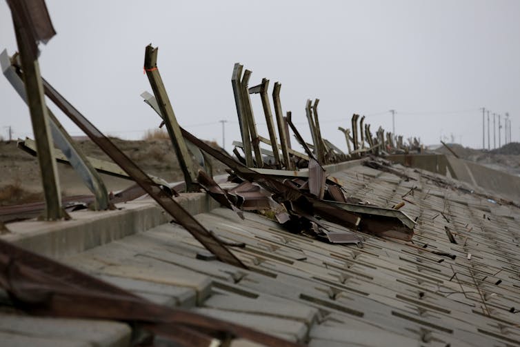
Many structures could not withstand the force of the tsunamis, or the damage caused by drifting vessels and wood debris. The ground liquefied and scour holes developed near foundations, causing the collapse of many buildings. Roughly two-thirds of the protective coastal forests were lost.
The post-tsunami survey and later research gathered detailed data about the causes and extent of the damage. This information can be used to reduce uncertainties when it comes to forecasting future events of this size. Thanks to this research, we now know more about the probability of similar earthquakes, have improved numerical models and can make better predictions about building failures. All of this will enhance the design and construction standards in Japan, and other countries that are prone to tsunamis.
Making a recovery
Before the end of 2011, the Japanese parliament had passed laws to establish “tsunami-safe cities”. This involved enhancing research and education, evacuation training and measures to prevent or mitigate the effect of tsunamis in the long term. The government also committed 25.5 trillion yen (£158bn) toward an intense, five-year period of rebuilding.
Next, the Reconstruction Design Council presented a plan to rebuild along Tohoku’s coast, based on new tsunami risk simulations and studies. The proposed protection was divided into two levels, which correspond to two classes of tsunamis, based on their magnitude and frequency. Level one (L1) are “smaller”, low-impact tsunamis that occur once every 10 to 100 years. Level two (L2) are rare, high-impact tsunamis which only happen once in several hundred to 1,000 years.
Structural measures such as seawalls, embankments and tree plantations will be designed and built to defend people and properties against L1 tsunamis. Soft measures such as land use zoning and evacuation plans will be implemented to protect human lives against L2 tsunamis.
A way to go yet
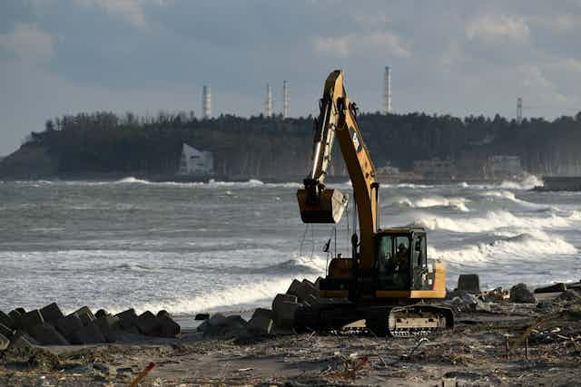
Putting these improvements into practice has taken longer than expected. The main focus is still on rehousing those whose homes were destroyed. At last count, almost 59,000 of the 470,000 people originally displaced are still living in temporary accommodation.
In many locations, the ground level of sites for new houses must be raised before construction can begin. For example, in the port town of Rikuzentakata, the ground level was raised by about 10m, and two protective seawalls of 3m and 12.5m high are being built. Elsewhere, private houses will be relocated to higher ground, areas behind protective structures will be elevated and forests planted. The Miyagi prefecture proposes to refortify the coast with a tall seawall several kilometres long for tsunami protection.
All of these measures take time, and many have divided opinion: some inhabitants do not want to move from the coastal strip, but neither do they want their view infringed by a tall wall.
Although the scientific research carried out after the 2011 tsunami will help to protect Japan from future disasters, there will always be shades of uncertainty. After all, it is unlikely that every possible combination of events has been predicted and accounted for. That’s why it is crucial to continue monitoring for early warning signs, evaluating predictive models and building physical defences. Perhaps most importantly, we need to raise awareness of the risks of coastal living, and ensure that people are prepared to move quickly when the need arises.