
The significant retreat of elements of the West Antarctic ice sheet such as the Thwaites glacier recently reported in the journal Science suggests a possible sea level rise of 3 to 3.7m. This is a huge increase in sea level that cannot fail to affect us all.
With so much of the world’s population living in low-lying cities, it seems more important now than ever that we’re able to make accurate predictions of sea level change. However, to do this we need to know not only how much ice is being lost from Antarctica and other frozen regions, but how the Earth’s surface deforms in response to that loss.
The trillions of tonnes of ice locked in ice sheets weighs heavily on the bedrock underneath it. As the mass of ice grows and shrinks, over geological time the Earth is compressed by the weight, or springs back as it melts, which in turn displaces more or less of the oceans and affects the extent of sea level rise.
This is tricky to calculate because the Earth deforms in two ways. There is an instantaneous elastic rebound of the crust, like a spring bouncing back after a weight has been taken off. This is followed by a very slow uplift due to movement of the mantle, the layer of semi-molten rock underlying the roughly 100 mile-thick hard outer crust.
Although we think of the mantle as rock, it flows like a highly viscous fluid when subject to changes in surface load. This typically occurs over many thousands of years, but the timescale depends on the viscosity of the mantle and how easily it can flow. As it is many miles below the surface and exists at temperatures of up to 1,000°C, we cannot directly measure its properties – so we have to infer them indirectly.
The big rebound
Our recent study of the Northern Antarctic Peninsula published in the journal Earth and Planetary Science Letters was a sort of fast-forward version of this problem. The mantle in this region is commonly thought to be less viscous and more mobile than in other parts of Antarctica. This means that it responds much more quickly to changes in pressure as ice is unloaded at the surface. We combined records of the significant loss of ice that has taken place here in the past ten to 15 years with GPS measurements of the Earth’s rebounding motion to unravel this problem on a regional scale.
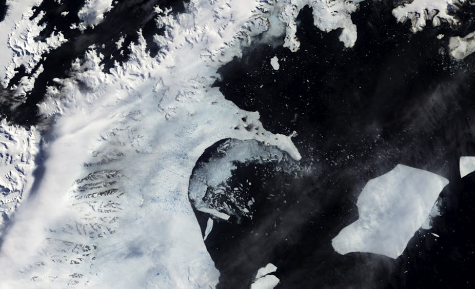
Over the past few decades, several ice shelves at the very tip of the Antarctic Peninsula have collapsed, with the result that glaciers flowing into where the shelves once were now deliver more ice into the sea. Satellites record the glaciers’ elevation frequently, so scientists can determine the rate of thinning and how much ice is lost from the land into the sea.
GPS transmitting stations fixed to the Antarctic bedrock record deformation of the Earth – and several sites have been installed in the Northern Antarctic Peninsula to measure the rebounding due to ice loss in this area. What we have discovered from this data is how quickly the Earth is moving 250 miles below the surface.

The instantaneous elastic rebound expected from the ice loss did not tally with the GPS records, leaving an unexplained and rapid rise of up to 15mm per year. This means that the remaining rebound has to come from the flow of the mantle pushing underneath.
We used the measurements to determine that the mantle viscosity had to be around ten times lower than previously thought for this region – and consequently has responded much more quickly to the lightening load at surface level – in scales of years rather than centuries. We can almost see it happening and being able to take accurate GPS measurements is incredibly useful. It also enables us to predict the amount of rebound much closer to the thinning glaciers than our current GPS sites, and based on what we know, this could be as much as 47mm per year.
This has really significant implications for the interpretation of GPS records, which are often used to verify models used in the prediction of sea-level rise and for measurements of the Earth’s gravitational field, which are used to detect ongoing changes in the mass of ice sheets.
So the glacier retreat reported in West Antarctica will also be driving further, rapid bedrock uplift. This could be as much as 5cm (2 inches) per year, but the historical GPS record in this region is still too short to provide detailed answers. As Antarctic glaciers continue to thin, the unloading of ice will provide an opportunity to probe the Earth in other parts of Antarctica.
While this is fortunate for earth scientists to pursue their interests, given that sea level rise affects everyone it’s not something we really welcome.