

A 7.5 magnitude earthquake shook Donggala and Palu in the island of Sulawesi, Indonesia on September 28, 2018, causing destruction that killed more than 1700 people. Not long, the public was shocked to see on social media pictures and videos from the disaster location showing soil flowing like a river, dragging along and wiping out houses and trees.
Liquefaction is a phenomenon when the soil loses its strength due to a sudden stress such as an earthquake. Aside from shocks and the potential of water rising from a tsunami, people also need to beware of liquefaction following an earthquake.
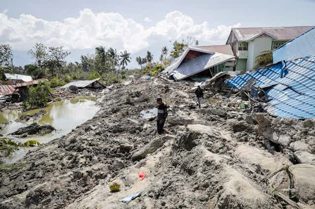
Building houses on soil that are prone to liquefaction is extremely dangerous. The houses in the Balaroa and Petobo villages, a few kilometres from Palu, were on such land. The houses were still standing when the earthquake hit, and they were not affected by the tsunami. But moments later, thousands of houses and people in the area were swallowed to the ground because of liquefaction.
A local TV station reported liquefaction affected an area of 320 hectares in Palu. While the term has only been widely discussed in Indonesia and the world in the past week, Palu’s susceptibility to liquefaction had already been studied. In 2012, Risna Widyaningrum from the Indonesian Geological Body conducted a study and wrote a report titled Geological Investigation of Liquefaction Potential in Palu Area, Central Sulawesi Province. The report concluded that the majority area in Palu had a high potential of soil liquefaction.
Ignored research
Experts explain that liquefaction susceptibility is influenced by three factors:
- below the soil surface exists a layer of sand less than 12 meters deep,
- the water table is below 10 meters,
- the earthquake’s magnitude.
Risna Widyaningrum’s report detailed the morphology, geology, and earthquake incidences that occur many times in the area known as Palu Koro fault. The Palu Koro fault stretches 60 km long north to south crossing the city of Palu and continues to the bay of Palu next to the city of Donggala. The Palu Koro fault is moving north at a rate of 40 mm per year, faster than the Semangko Sumatra fault that moves at a rate of 15 mm per year.
The report found that the soil in the Palu area is from alluvial sediments of the Quaternary period. The soil is alluvium, with a sandy layer on top (1- 7m), followed by a layer of loam underneath, and finally a clay layer. A map showed that the groundwater level is considered shallow (less than 12 m from the surface). Locals said that the Bolaroa area was previously a swamp, but was built-up and made into a town. Findings from the 2012 report showed that the area is highly susceptible to liquefaction.
The end of the report shows three zones of liquefaction hazard: low, high, and very high risk. Petobo and Balaroa villages are in the very high-risk zone. The report recommends that building foundations should not be established on the sand layers. Also, spatial planning of housing, industry and important buildings should be made on areas of low LPI.
Soil texture
Soil science can explain how solid soil can move and swallow thousands of houses.
Soil is made up of minerals of smaller than 2 mm in diameter. These solid particles are grouped based on their sizes: the coarsest is sand (diameter 0.05 to 2 mm), silt (0.05 mm to 2 micrometers), and the finest is clay (diameter less than 2 micrometers). The mixture of these three components determine the soil textures. A coarse-textured soil has more sand and less silt and clay. There’s also medium and fine-textured soils. The coarser the texture, the more susceptible it is to be liquefied.
Clay holds soil particles together forming larger aggregates. Strong and stable aggregates support the growth of root plants. A tree can grow large and tall because it stands on a well-aggregated soil that support the tree. Soil with high strength forms a good foundation for buildings.
In between the soil particles and aggregates, there are pore spaces. These pores supply air and water to plants. The finer the pores, the stronger water is held by the soil particles.
Coarse-textured soils tend to have larger pores. When rain drops onto the soil, water fills the pores. When the pores are full with water, they become saturated, and further water addition will cause floods. With water inside the pores of the soil, it can also form layers within the mineral particles, diminishing the soil’s cohesive forces. Clay particles when saturated can also slake and disperse.
We can witness this in our daily lives. For example after a heavy rainfall you shouldn’t drive a car on a wet soil lest it’ll get stuck. A sand castle will erect tall if it has a bit of water but will collapse if it has too much. A landslide occurs when the soil “fails” because of saturation.
What causes soil liquefaction
When the strong earthquake shook Palu, the violent tremor underground caused groundwater to move and seep to the soil pores with high pressure. The strong and sudden pressure to the soil pores caused soil particles to disperse, losing its strength, turning into mud, bringing down any building above it. The violent shake also stir the mud and caused it to flow like river, washing away anything above it: houses, plants, and human.
We can do a simple test by taking a lump of sand and a lump of clay soil. If we pour a cup of water to the sand, it quickly becomes liquid. But if we pour a cup of water to clay, it tends to be stable.
Imagine buildings that sit on the top of these two different soils. Low-lying alluvial area that is dominated by sandy materials (thickness less than 12 m) and has a shallow water table (less than 10 m) would be highly susceptible to liquefaction.
The susceptibility of an area to liquefaction can be quantified using a measure called Liquefaction Potential Index (LPI). LPI was formulated by Toshio Iwasaki in 1978, as Japan frequently suffers from earthquake and faces danger of liquefaction. LPI values below five are considered low, values between 5-15 are considered high, and above 15 are very high.
This index was calculated as a function of soil’s particle size and the earthquake’s strength. Areas with sandy soil with low groundwater level are considered highly susceptible to liquefaction and have LPI values greater than 15.
Japanese engineers also took into account this index in structural design and building zoning. This is a good example that the research finding is put in practice and serves in policy making.
However, as it generally happened in Indonesia, and some other countries, findings and reports made by experts were rarely followed up by policy and decision makers. We should learn from the disaster in Palu and not leave research findings unused on a shelf in the office and the library. Research dissemination on important findings such as the liquefaction susceptibility of an area should be communicated to policymakers.
This soil calamity can be avoided if we carefully consider the conditions of our soil and land when we build infrastructure. When building new homes for the earthquake victims policymakers and planners should pay attention to liquefaction hazardous to avoid many casualties next time the earth shakes again.