
With another week of hot weather in southeast Australia, we’re all on watch for the outbreak of bushfires. Fire warnings and bans are currently out for Tasmania, Victoria, and South Australia, with a potentially dangerous fire breaking out in southeast Tasmania. Fires may be a fact of life, but have we learned anything from the past?
The Tasmanian bushfire inquiry released last year focused on the fire that destroyed numerous properties on the Tasman Peninsula, including many in and around Dunalley. The inquiry found bushfire modelling was inadequately used to warn the public.
But modelling isn’t the problem here. It’s getting people used to the idea of living in a landscape in which bushfires are a fact of life.
A tale of two bushfires
The January 4 fire that consumed properties at Dunalley wasn’t the only fire in Tasmania’s 2013 bushfire season. On February 18, another fire began at Gretna, 40 km northwest of Hobart.
Starting from a car that lost its wheel around 3:50pm, the Tasmanian Fire Service quickly fed the location of the fire and weather details into its Phoenix-Rapidfire predictive model. The nearest weather station at Bushy Park recorded a temperature of 36.6C at 4pm with a stiff northerly blowing at 33 kilometres an hour. The model put the fire at New Norfolk by 10pm that night, 20 km away with a population of 5,000.
That result triggered an immediate response. Six helicopters, one fixed wing aircraft and 20 fire crews were directed to the blaze.
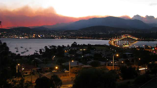
By 7:45 that evening the fire had been contained after some heroic water bombing. It burnt 220 hectares but there were no houses lost and no reported injuries. A major factor in that decisive action was another fire at Molesworth at the back of Mt Wellington, which started the same afternoon. It was only 20 km northwest of Hobart in difficult terrain and heading directly for the city. Having two fires out of control, upwind of a city of 200,000, was just not tenable.
While the Dunalley fires rightly captured the attention of the world, the vast majority of Hobart’s residents are still oblivious to the risk presented by the fires north of Hobart and the effort that went into fighting them.
What was the difference?
The inquiry into the Dunalley fire singled out inadequate use of predictive modelling in its criticism of the Tasmanian Fire Service, the same modelling used in the response to the Gretna fire. In the case of the Gretna and Molesworth fires, swift and decisive action more than likely saved Hobart from a disaster.
So what was the difference? First the February fires were outside the brief of the inquiry. Otherwise the same forensic attention the inquiry paid to the Forcett-Dunalley fire would have been directed to the Gretna and Molesworth fires and the near miss would be public knowledge. The other factors were weather and terrain.
The weather on the day of the Dunalley fire ranged from severe to extreme across southern Tasmania, setting an all-time record of 41.8C and making suppression somewhere between “unlikely” and “not feasible”. The Dunalley fire was clocked at over 40m per minute or 2.5 kilometres an hour; which is extreme fire behaviour.
Combined with wooded and inaccessible terrain and much higher fuel loads, it was simply not possible to achieve the same result as the Gretna fire for similar effort. But at Gretna the modelling was used appropriately, guiding very effective response in the short term.
The bigger point in all this is that fire is more a social problem than a scientific or logistical one. The risks of living in an environment that invites fire are not widely understood or accepted by those of us who chose to live in Australia’s bush capitals. Until this is acknowledged and the burden shared, there will be more near misses and more losses.
In the 1967 Tasmanian fires 62 people died and 1,400 houses were burnt. Based simply on proximity to the bush, fuel load and the likelihood of hot windy days, fires of those proportions will happen again. Disaster will only be avoided if we are prepared in numbers.
Survival in this environment is a property of the whole community, not the sole responsibility of its institutions.
Why bushfires are like sea level rise
Short of more dramatic and frequent warnings which will lead to alarm fatigue, what could we do? Recently the Tasmanian Government published maps showing the risk to coastal areas from sea level rise. This angered many people as it had immediate implications for property values.
The equivalent could be done for fire risk, along with building codes that incorporated fire resistant materials, protection against ember attack, and buffer zones based on the lessons from the 2009 Victorian fires. That would also anger people, but save lives.
Towns and cities have only been a feature of the Tasmanian landscape for 200 years, yet the story emerging from tree rings and lake sediments suggests the really big fires, the last of which was in the 15th century, may come around only once in every 400 to 500 years.
Gretna was a good example of the tactical power of modelling, used as an aid to decisive action in the short term. Predicting with any precision when fires will hit a particular location over longer periods will always be challenging because of the confounding uncertainties of weather and local conditions.
What can be done with some precision is identify where they are likely to do damage, but not when. Powerful geo-spatial tools are available that can combine risks associated with aspect, vegetation growth, climate and recent history. The Tasmanian coastal risk mapping is a bold precedent, and there is even more to gain by giving fire the same treatment.