
Just days after North Korea announced it was suspending its testing programme, scientists revealed that the country’s underground nuclear test site had partially collapsed. This assessment was based on data gathered from smaller earthquakes that followed North Korea’s biggest nuclear test in 2017. A new study published in Science has now confirmed the collapse using satellite radar imaging.
The collapse may have played a role in North Korea’s change in policy. If correct, and with the hindsight of this research, we might have speculated that the North Koreans would want to make such an offer of peace. This shows how scientific analysis normally reserved for studying natural earthquakes can be a powerful tool in deciphering political decisions and predicting future policy across the globe.
In fact, another unusual earthquake in South Korea in 2017 also has the potential to affect geo-politics, this time by changing energy policy. “Seismic shift” may be a cliche often used by journalists and policymakers to describe changing political landscapes, but these recent earthquakes along the Korean Peninsula remind us there can really be authentic links between seismic events and global affairs.
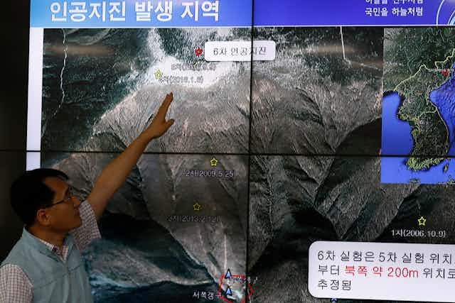
On November 3 2017, North Korea announced that it had successfully tested a thermo-nuclear hydrogen bomb. Global monitoring networks of the Comprehensive Test Ban Treaty Organisation (CTBTO) detected this explosion within minutes of it happening, classifying it as a magnitude 6 seismic event. We knew that this event was caused by an explosion because all the fastest-travelling seismic waves (“P-waves”) detected on seismometer instruments around the world caused the ground to initially move in an upwards motion. The energy released by the test was equivalent to up to 300 kilotonnes of TNT explosive.
While this H-bomb test sent diplomatic shudders around the world, it is what happened in the minutes to weeks after the explosion that might have determined the future of nuclear testing on the Korean peninsula. The recent studies revealed the mechanism of a magnitude 4.5 aftershock that occurred eight minutes after the initial explosion. Analysis of the slow-travelling, rolling seismic waves from this event, together with a 50-centimetre drop of the summit of the mountain above recorded by satellite images, revealed large-scale collapse of the test site and adjacent tunnel system.
Mount Mantap is North’s Korea’s only active nuclear test site, hosting of all the country’s nuclear tests since the country first went nuclear in 2006. Given the scientific evidence for the collapse, the test site, located 450 metres beneath the summit of the mountain, may have been rendered unusable. If so, this may have contributed to North Korea’s decision to give up nuclear testing, instead of it being solely due to the diplomatic efforts of the US, South Korea and China.

Two weeks after the North Korea nuclear test, an unrelated magnitude 5.4 earthquake struck South Korea, the most damaging in the country since detailed records began at the start of the 20th century. The earthquake occurred close to a site that is testing the feasibility of extracting natural geothermal energy from the ground. Cold water is injected into the ground at high pressures to stimulate the movement of hot geothermal fluids along pre-existing fractures in the rock. This process is subtly different to hydraulic fracturing for oil and gas (commonly called “fracking”), which involves creating new fractures.
Two independent studies published in Science used detailed seismic measurements of this earthquake and its aftershock sequence to show that the rupture occurred at a shallow depth of around four kilometres. This is normally too shallow for natural earthquakes but is about the depth of the bottom of the geothermal well. As with the seismic events in North Korea, these events did not involve simple slip along a single, straight geological fault.
Even though South Korea is far from an active tectonic plate boundary, the earthquake demonstrates how ancient faults that appear dormant for long periods of time actually lie close to failure. Tiny nudges of these faults can cause them to slip and release seismic energy, and injecting fluids at high rates into Earth’s crust can do just this.
Fate determined by earthquakes
Similar sized events have occurred in recent years in Oklahoma, US, from the injection of wastewater from oil and gas production. Any large-scale process that causes changes in fluid pressure in the ground, even storing water in surface reservoirs, has the potential to induce earthquakes.
The fate of these industries that extract energy from the ground are crucial in determining whether we meet our targets for reducing greenhouse gas emissions. If such a large earthquake is an inherent risk, we might have to rethink the use of geothermal energy and rely on traditional, higher-emission sources of energy for longer. Equally, the oil and gas industry may have to rethink its more unconventional techniques, depending on the local geological setting of certain extraction sites, which could speed up the decline of fossil fuels. Understanding the seismic activity that is related to them could help us determine whether such extraction can be done safely, and in turn, the popular and political support they could have.
In these ways, detailed analysis of tiny seismic vibrations around the world can provide crucial evidence for understanding how the world will change in the future. And that’s on top of the value of studying man-made earthquakes in order to better understand – and potentially mitigate – the risks of natural quakes.