Millions of years ago, widespread volcano eruptions in eastern Australia buried entire forests. Today, these time capsules reveal stunningly fossilised plants.
To fight global warming we will soon have to try to remove carbon dioxide from the skies or find ways to reflect the Sun’s heat. Such radical paths must be examined, but risky experiments avoided.
Lava flows from a fissure near Grindavik, Iceland, on Jan. 14, 2024.
Iceland Department of Civil Protection
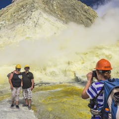
Everyone involved in the tourism industry will need to manage risk differently after a court found the landowners of Whakaari/White Island guilty of breaching the Health and Safety at Work Act.
Hrafntinna (Obsidian), 2021, Jónsi. Courtesy of the artist and Tanya Bonakdar Gallery, New York/Los Angeles.
Photo Credit: Mona/Jesse Hunniford Image Courtesy Museum of Old and New Art, Hobart, Tasmania, Australia.
Pandemic restrictions prevented Jónsi (frontman of Sigur Rós) from experiencing firsthand the eruption of Fagradalsfjall, Iceland. He made this work in response.
More than 90% of the world’s pink diamonds came from a single mine that closed in 2020. Geologists are only now beginning to understand the forces that create the rare, highly prized gems.
For some people, it’s a choice based on cultural beliefs or economic opportunities provided by the volcano. Other times it’s less a choice than the only option.