
The coastal region of the Atacama Desert in the north of Chile is one of the driest places on Earth. Less than a millimetre of rain falls there per year on average.
It is hard to imagine that plants could grow in such inhospitable conditions. And yet, they do: Tillandsia landbeckii, a genus of plant from the pineapple family (Bromeliaceae), survive in the desert by ‘combing’ water out of the fog that rolls in from the nearby coast.
These plants also function as an indicator for climate change and for the availability of fog water, which can also be used by humans as a sustainable water source.
Desert fog
The climate of the Atacama Desert is largely shaped by a quasi-permanent high-pressure cell over the South Pacific along the Chilean-Peruvian coast, which creates a thermal inversion layer – where the air increases in temperature the higher you get in the bottom part of the atmosphere. In the inversion layer, the moist, cool air of the Pacific is separated from the dry-warm air masses above.
As a result, extensive stratocumulus clouds form in the air layer closest to the ground, but they do not bring any rain. This process is supported by the Humboldt Current – a cold Pacific current that flows north along the coast of South America.
Fog is created along the coast where the layer of cloud hits the ground. This fog can penetrate several kilometres inland before it dissolves due to the dryness of the Atacama Desert. The frequency, intensity and spread of fog are subject to strong fluctuations based on the season and time of day.
Adapting to the desert
Atacama ecosystems are very vulnerable to changes in fog frequency and intensity. Tillandsia landbeckii has adapted to the extreme drought during its evolution and occurs as an endemic species only in the fog ecosystems of the Atacama Desert.
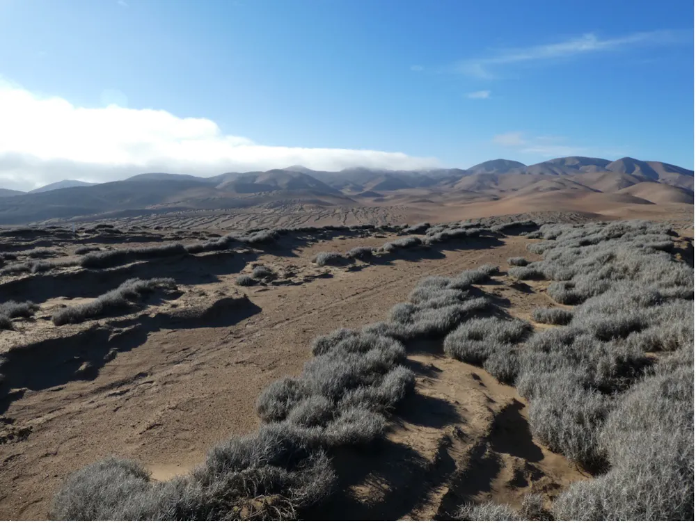
The plant has no roots, instead using its older, dead parts to stick to the sand, which gathers around it like a small dune. The plants comb out the moisture in the mist using their thin leaves and shoots, which swell as soon as they come into contact with water.
Nocturnal dew seems to be another source of water, especially in the summer months with little fog. Together, these groups of plants are known as ‘lomas vegetation’.
Collecting fog
The distribution of this type of vegetation in the Atacama Desert is limited to a narrow area along the coast, where fog occurs regularly. The distance to the Pacific, the prevailing wind direction and topography (height, inclination and exposure to the main wind direction) significantly limit the distribution of fog ecosystems.
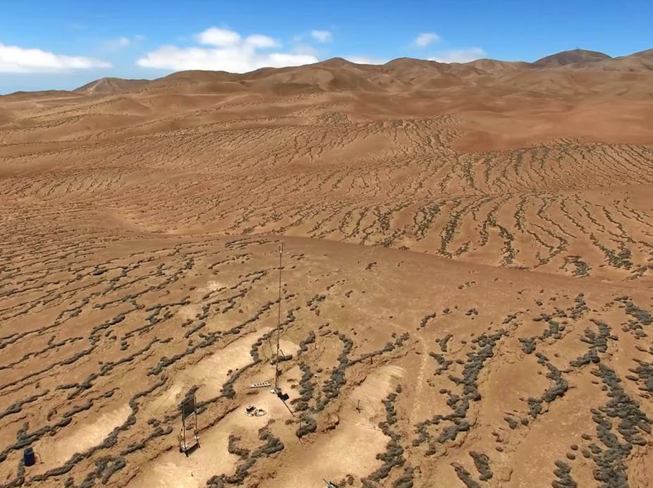
By analysing satellite data, we can see that Tillandsia stocks are situated between 800 m and 1,250 m above sea level and from 3 km to 45 km inland, mostly on sandy plains along fog corridors or on slopes exposed to the west or south-west.
Groups of Tillandsia landbeckii stand up to half a meter high in a ribbon-like structure that runs perpendicular to the prevailing wind direction. The Tillandsia are thus optimally exposed to the supply of moisture and nutrients. Row spacing, width and density are largely dependent on the amount of available fog water and thus also a good indicator of general water availability.
On the basis of satellite and drone data, we can analyse and model the plant population, including growth rates and genetic variability between plants, to better understand the prevailing conditions.
We compare the results from the Tillandsia distribution with data from the seven climate measuring stations which are installed at different heights and distances from the sea. At these stations, air temperature, relative humidity, wind speed and direction, fog water amount, dew and leaf moisture can all be measured within a ten-minute period, and the corresponding data can be transmitted via satellite to the Department of Geography at Heidelberg University of Education, where I work.
We measure the amount of water in the air using standard fog collectors – a one square meter frame covered with a special net, which is set up at a height of two metres, perpendicular to the main wind direction.

Within one week at the climate station in Cerro Oyarbide, 15 km from the coast, we measured 6.7 litres of fog water an altitude of 1,077 m. Just 2.5 km away, we measured 14.4 litres at an altitude of 1,218 m. At another nearby climate station at an altitude of 1,350 m, we only recorded 0.1 litres – this station is above the inversion layer, over which the fog does not appear.
Analysing this data over time, between 1998 and 2014, we see a slight decrease in the amount of water generated by fog during this period. This goes hand in hand with a decrease in the height of the thermal inversion layer. This lowers the upper limit of the stratocumulus cloud cover and thus the fog generated from it.
Based on this, it’s fair to say that, in the future, some of the higher areas of Tillandsia will lie outside the zones from which they can collect water.
Fog as a sustainable water source
The results from our years of research show that lessons from this hardy desert plant can be used to help human populations trap their own water from fog.
In coastal cities like Iquique and in smaller fishing villages on the edge of the desert, water resources are very limited. Water rights are privatised, and correspondingly expensive. Because of the extensive extraction of raw materials such as copper and lithium, used in the production of batteries, which require huge amounts of water, demand will continue to increase significantly in the coming years.
Domestic and drinking water has so far been obtained primarily from groundwater, but there could be lessons for humans in the distribution and behaviour of these plants.
There are close connections between the ribbon-like structure of the Tillandsia stocks, their growth rates and the measured fog water quantities. On this basis, we can develop a geo-ecological niche modelling of this unique fog ecosystem.
This can be used, among other things, to analyse suitable locations for fog trap nets, through which fog water can be gathered as a sustainable water source for the local population.

For 50 years, the UNESCO Man and the Biosphere Program (MAB) has combined exact, natural and social sciences to find solutions implemented in the 714 exceptional sites (129 countries) of biosphere reserves.