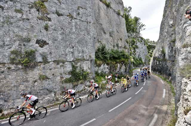

As I write this, the Tour de France has reached its halfway point, with the cyclists climbing the Alps. Or, to put it another way, the race has left Armorican continent and entered the folded relics of the Valais Ocean and the Briançonnais microcontinent.
For me, as an academic geologist and cycling enthusiast, this year’s edition of the world’s biggest cycle race is particularly exciting as colleagues and I launched the Geology of the Tour de France blog and the @GeoTdF twitter account.
The project first came about when we noticed how much time the TV commentators had to fill while the riders cycle through interesting landscapes. Though viewers watch for hours in anticipation of the action that will end every stage, for most of that time 150 riders are chasing five or so others with little change to the status quo. In that time, the broadcasters explain everything about almost everything you can see on screen.
Organisers of cycling races therefore provide the commentators with a Lonely Planet-style route book with information about castles, cities and individuals. And then it struck me: we are not only watching potential holiday destinations, but also geological excursions. All we had to do is provide the commentators with geo-information.
So I assembled a team of 28 geoscientists and web developers, several from my department at Utrecht University in the Netherlands, but also from institutes in France, Germany, Denmark, Spain, the UK and the US, who together wrote 29 blogs about the geology along the Tour de France stages, and translated these into seven languages.
For the men’s tour, each blog explains a geological phenomenon or process whose signatures are visible along the stage route. We’re looking at many different topics, from the extinction of the dinosaurs to the subduction zones of the Alps, and from the origin of the volcanoes of the Massif Central to the question why the Jura Mountains of stage 8 are a separate range from the Alps.
The Tour de France Femmes begins on the day the men’s tour finishes, and the women’s peloton will race over older rocks every day in the Paris Basin and the Vosges mountains of eastern France. Each blog of the Tour de France Femmes explains what the world would have looked like if the race was held when the rocks below the road formed. The blogs offer a five minute read, but if you read them every day, you end up with a extended geology class.
Public and scientific benefits
The GeoTdF project aims to be a light-hearted way to educate people about processes that impact our society, from landslides and earthquakes to the finding of ore deposits that we need for the green energy revolution. And the public can respond and ask questions through Twitter.
But the project also has scientific benefits. It provides geoscientists and our colleagues with a platform to showcase our findings, for all of us who want to share knowledge and insight freely and enthusiastically.
This is why I like the project so much. Scientists are always trying to find where they are wrong, for that is where they can learn and advance. As a result, they are always scrutinising themselves and each other, through peer review, discussion, debates. The criticism is vocal, the appreciation silent. That wears me down at times. The sense of community and enthusiasm around the GeoTdF project is a nice change. So if you have something to tell or ask, please join in.
At the same time, letting something as random as cycling routes determine the order in which you read up on geology turns out to be an idea and knowledge generator. Natural scientists logically tend to choose the boundaries of their study areas based on interpreted system boundaries, and dig deeper into the details to find how the natural world works, but it comes with the risk of tunnel vision.
I have studied plate tectonics and mountain building, through systematically finding the same geological systems and boundaries and reconstructing them (for instance in the Mediterranean region).
But cycling route designers force me to cross all those boundaries. No geologist would read up on a region along such a geologically non-organised and random route as a Tour de France stage – and doing so is eye-opening. I learned that the cliffs of Stevns Klint in Denmark close to stage 2, and of Calais in north west France in stage 4 are the same formation of upper Cretaceous chalks. And that the uplift in the past 20 million years of the Ardennes hills of stage 6 and the Massif Central of stage 15 are both associated with formation of intraplate volcanic fields that may suggest a common underlying process.
Many of these chance observations connect pieces of knowledge that I picked up during my career, and some of them challenge systems that I thought I understood. As the writer Isaac Asimov is believed to have said, scientific discovery rarely starts with “Eureka!” but normally with “Hey, that’s funny.” Whether the GeoTdF project will lead to the former remains to be seen, but it certainly is fun.