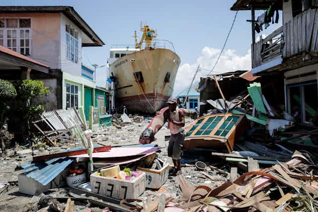

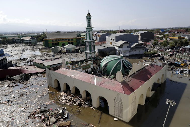
The recent earthquake and tsunami in Indonesia has claimed the lives of at least 1,350 people. Many more people are missing and the disaster has destroyed homes and businesses across the city of Palu and surrounding area on the island of Sulawesi.
Yet after the much larger tsunami that devastated countries around the Indian Ocean in 2004, Indonesia began installing a new early warning system to try to prevent such widespread destruction from happening again. So why is the country once again facing such a severe loss of life? The location of the tsunami may have made the destruction particularly acute, but the country’s early warning system also appears not to have lived up to expectations.
A tsunami (Japanese for “harbour wave”) is formed when a disturbance on the sea floor leads to a series of large waves which spread out across the ocean. This disturbance can be caused by a large earthquake, an underwater landslide, or even a volcanic eruption.
When the tsunami waves reach shallow water as they move towards the shore, the speed of the wave slows down and causes the water to dramatically pile up. The increase in wave height leads to devastating coastal flooding especially in highly populated, low-lying areas.
The height of the wave depends on the size of the tsunami wave but also by the shape of the coastline. For example, tsunamis will have a greater impact where the wave moves through a narrow, elongated bay, like Palu, as it approaches the shore. The earthquake in Sulawesi likely disturbed sediments on the seabed and triggered a local underwater landslide. These two factors combined could explain the six-metre waves that reached Palu.
More than one wave can occur during a tsunami, meaning that such events can continue to impact the coastline over a number of hours. It can be the case that the second, third or even later waves can be the biggest.
Early warning systems
Unfortunately it isn’t possible to predict exactly when a tsunami may strike a coastal area, but there are clues that can save lives. Indonesia’s main early warning system is made up of a network of tidal gauges that measure sea level, and land-based stations that detect earthquake activity. However, the tidal gauges were so far away from Palu that they only registered a small rise in the water level as the waves started to form. It’s possible the system wasn’t set up to take into account how the waves would grow as they travelled down Palu’s bay.
A more advanced warning system is more common in some areas of the world affected by tsunamis and earthquakes, using a series of buoys in the sea to detect any movement of the seafloor. In the event of a tsunami, the buoys send a signal to the local agency responsible for issuing a clear advance warning to coastal residents to allow people to get to higher ground away from the advancing waters.
Indonesia has installed a new sea-based system but some researchers have said that it is stuck in the testing phase, and that the ocean buoys deployed aren’t working properly. They point to a potential life-saving early warning system hampered by lack of funding and delays, despite the very real threat from tsunamis in this part of the world following the 2004 event.
There may have also been a problem with the way the information about the incoming waves was used. The Indonesian authorities in this case did issue a tsunami warning via text message, but the earthquake destroyed many cellphone towers. Similarly, damage to power lines reportedly prevented sirens from working. The authorities have also been accused of cancelling the warning too soon.
Unfortunately, Sulawesi has paid the price for an incomplete tsunami warning system as well underestimating the wave heights that actually struck the coastline.