
Viewers of HBO’s Game of Thrones will be familiar with the map of the fictional world that accompanies the opening credits. This world is based on a set of books by George R R Martin – and across all seven series, the maps have played a pivotal role. But in the latest series, maps have taken on a whole new significance.
Eagle-eyed watchers have long looked at the opening sequence for clues as the animated map reflects the geographical areas to be covered in that episode. The creative director behind the opening credits has said that he was asked to realise the maps for the titles to help viewers to understand where and when the action was taking place – Martin had already created maps, as well as genealogies for the noble houses, while he was writing the novels.
The shape of Westeros, the continent where most of Game of Thrones takes place, is based on the United Kingdom and the Republic of Ireland. While there are other geographical similarities, such as lakes and rivers in familiar locations, the main difference is that Westeros is many times larger.
Many books include maps – from the Lord of the Rings’ Middle Earth to Winnie The Pooh’s Hundred Acre Wood. These fictional maps teach us about fantasy worlds and, as The Guardian’s Ciara Murphy wrote: “provide gateways to the imaginary lands which may otherwise only exist within our imaginations”.
The Game of Thrones maps have helped audiences to visualise the sprawling world they are discovering. The map has even become so popular that fans can trace the stories of their favourite characters through an interactive version or buy it on a variety of products. Westeros can be bought etched into wallets, phone cases or as a Tube map version.
Shaping the world
Geographers are interested in the relationship between maps and power. Maps are not neutral representations of the world around us; instead they help to shape it. As the geographer J B Harley argued, historically “maps have been the weapons of imperialism”, allowing colonial powers to claim land and eventually exploit defined colonies.
Maps help us to visualise space in ways that can be far from benign. As Christopher Marlowe wrote in Tamburlaine the Great:
Give me a map; then let me see how much is left for me to conquer all the world.
Harley also argued that maps go hand-in-hand with the rise of the nation state. Maps allow rulers to define their existing territories and to plan military operations to claim others.
Maps can never be a precisely accurate representation of the world that we live in – the practicalities of transferring our spherical planet onto a two-dimensional page or screen makes this an impossibility. This means any map can be analysed to assess whether it is naturalising power relations, pursuing an agenda, or trying to tell a story.
There is a certain power even to the maps we use in our everyday lives. Think about buying a map to go on holiday to New York, for example. Which areas of the city will be located within the map’s boundaries? Which attractions will be marked – and which will not? Even fictional maps can be interrogated to tell us more about the world they intend to portray.
The queens’ maps
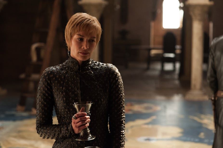
This season of Game of Thrones has seen maps rise to a new prominence. As the two queens, Cersei and Daenerys, vie for control of the Seven Kingdoms they are both consulting enormous maps.
While the reigning queen of Westeros, Cersei Lannister, has commissioned an intricately painted floor map, her rival owns a topographical model carved out of rock. Glossy appearances versus stony practicalities, perhaps. Daenerys’ map was first seen with Stannis Baratheon and sits in the descriptively named Chamber of the Painted Table. Martin’s books describe a raised chair situated at Dragonstone, the map’s location, that allows the occupant to gaze across the entire 50-foot map.

But what do these maps suggest for viewers of the series? The sheer size of these maps reveal the ambition of both characters who are envisaging victory on a grand scale. This is a literal marking of territory, but also shows how they are thinking tactically. Almost like the board game Risk, they are plotting their next moves using the geographical plans in front of them. Daenerys’s map even includes figures that can be moved and toppled in relation to her war plans. It could be prophetic that her map was built by Aegon the Great – Daenerys’s ancestor who became the first Lord of the Seven Kingdoms.
J B Harley was interested in the “silences” in maps – the elements or places that are left off. Looking at the two queens’ maps, Cersei includes only one of the three main continents in this fictional world – Westeros – but not Essos or Sothoryos. Daenerys’s inherited map is also of Westeros, despite the fact that she has spent the previous six series in Essos. This places the seventh – and penultimate – series as a battle for Westeros and is reflected in the opening sequence which in recent episodes has not travelled east to Essos.
We will have to wait to see which queen will become the ruler of Westeros (if the White Walkers don’t get there first) but if these maps are anything to go by, the clash will be on a scale unlike any other.