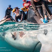
The toll on wildlife from illegal fishing, bycatch and entanglement in fishing gear is likely underestimated, because it doesn’t account for ‘dark’ fishing vessels, a new study finds.
Satellite data shows wildfires are destroying large areas of timber-producing forests around the world. These fires are becoming more destructive with each passing year.
We used satellite data to create global maps of where and how fires are burning. Fire season lasts two weeks longer than it used to and fires are more intense. But there are regional differences.
Satellite imagery shows how burnt areas in central Arnhem Land are lines carefully ‘painted’ across the landscape.
Sentinel Hub EO Browser
Two decades of satellite data have allowed us to map fires across the country and identify areas facing high fire risks. Fire activity has increased in several major regions over the past decade.
SpaceX’s Starlink service is slowly arriving in Africa, starting with Nigeria and Rwanda.
Wirestock Creators/Shutterstock
Cellphones are constantly collecting location data from global satellites, but there is uncertainty about who is using these data, and for what purposes.
Over half of the human genome contains repetitive DNA sequences whose functions are still not fully understood.
Malte Mueller/fStop via Getty Images
Forced labor is a widespread problem in fisheries on the high seas. Between 2012 and 2018, an estimated 100,000 people may have been victims of forced labor on thousands of different boats.