Chances are small that space junk will destroy property or harm a person, and existing space law could deal with such an event. But current law doesn’t address the bigger problem of space pollution.
China’s Long March 5B rocket, part of which will plummet back to Earth in the coming weeks.
Matjaz Tancic/EPA
China’s Long March 5B rocket, after a successful blast-off in April to deliver a space station module, is now on track to crash-land somewhere with a latitude between New York and New Zealand.
Earth orbit is filling up with satellites and space junk. Technological fixes can only go so far to deal with the problem.
Modern computing allows to spot isolated trees and shrubs in semi-arid areas, facilitating research on the evolution of vegetation cover.
Martin Brandt
Advanced techniques allowed our research team to build an open database of billions of individual trees and challenge some common perceptions about vegetation in arid and semi-arid zones.
Satellites affect your life every day.
Shutterstock
SpaceX’s satellites will populate the night sky, affecting how we observe the stars. And this is just the beginning of private satellite mega-constellations.
A partial lunar eclipse above the Jodrell Bank Observatory in Cheshire in 2019.
Peter Byrne/PA Archive/PA Images
Roland Lehoucq, Commissariat à l’énergie atomique et aux énergies alternatives (CEA) and François Graner, Université Paris Cité
By 2025 Elon Musk wants to launch 12,000 satellites and corner the global Internet market. What will be lost is earth-based astronomy, the idea that space belongs to us all and the beauty of a starry sky.
A weather buoy floats in Lake Michigan.
(Shutterstock)
The COVID-19 pandemic hasn’t just disrupted our lives. It has also challenged the way we forecast the weather.
Two CubeSats, part of a constellation built and operated by Planet Labs Inc. to take images of Earth, were launched from the International Space Station on May 17, 2016.
NASA
SpaceX and other companies are rushing to put thousands of small, inexpensive satellites in orbit, but pressure to keep costs low and a lack of regulation leave those satellites vulnerable to hackers.
The now defunct Infrared Astronomical Telescope was one of the satellites involved in the near-collision.
NASA/JPL
Two defunct satellites passed within metres of one another, prompting renewed focus on the dangers of space debris. But with many satellites treated as military secrets, how do we track the hazards?
The electromagnetic spectrum we can access with current technologies is completely occupied. This means experts have to think of creative ways to meet our rocketing demands for data.
NASA Johnson/Flickr
Free space optical communication will allow the same connectivity in space we already have on Earth. And this will provide benefits across a number of sectors.
Spaceports close to the equator are ideal for low-orbit launches. Currently there are only two, both in South America.
Shutterstock
India may soon follow in the footsteps of Asian space giants China and India, after the National Institute of Aeronautics and Space (LAPAN) announced a plan to build a spaceport in Papua.
India’s launch vehicle carrying Chandrayaan-2 lifted off from Sriharikota, India, in late July 2019.
Indian Space Research Organization via AP
Are India and China engaged in a new space race? India’s increasingly ambitious space ventures, including its Chandrayaan-2 lunar mission, are evidence of the country’s interest in space exploration.
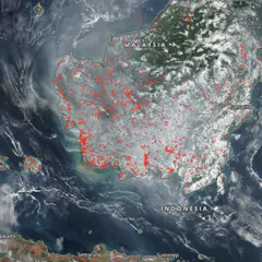
Active fire hotspots detected by S-NPP/VIIRS on September 7 2019.
NASA Worldview
We have developed an online tool to help authorities identify which areas they should focus on for reducing forest fires and haze in order to maximize overall health benefits.
Visualization of the Tropical Rainfall Measuring Mission satellite in space over a tropical cyclone.
NASA
Emad Hasan, Binghamton University, State University of New York and Aondover Tarhule, Binghamton University, State University of New York
Climate change threatens the water supply of nations around the world. But it’s difficult to measure whether a region has sufficient water to satisfy the people who live there. Could satellites help?