

It is now more than three years since Malaysia Airlines flight MH370 disappeared, and there is growing evidence that the search authorities have been looking for the aircraft in the wrong place.
The disappearance, on March 8, 2014, is considered as one of the biggest mysteries in aviation and the search of the seabed for the wreckage, costing A$200 million to date, is also the most expensive.
An underwater search of a 120,000 square kilometre area of the Indian Ocean, off Western Australia, has so far failed to find any evidence of the crash site.
The search was suspended in January this year until any “credible new information” should emerge that could be used to identify the specific location of the aircraft.
Initial search data
Initial evidence on the aircraft flight path was through satellite data (SatCom) from Inmarsat. This indicated that the plane most likely ended up in the southeast Indian Ocean along an arc – the 7th arc – that was the basis for defining the search areas by the Australian Air Transport Safety Board (ATSB).
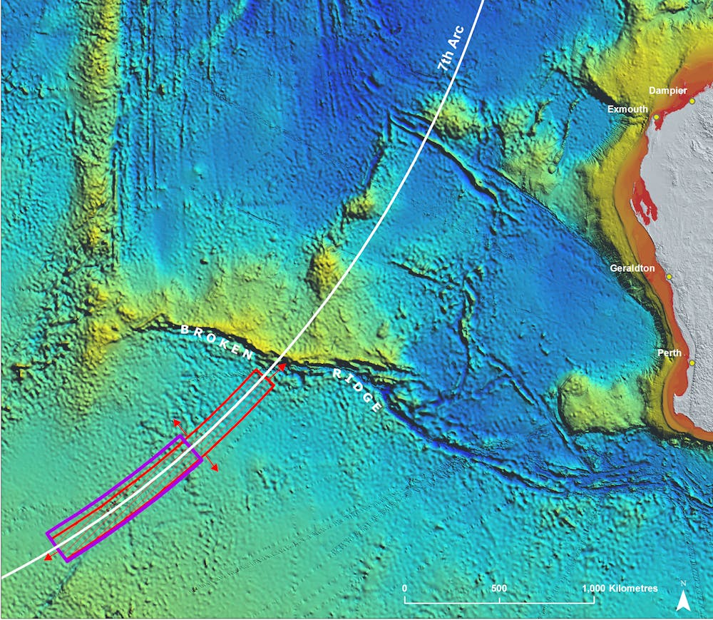
Considering several end-of-flight scenarios, the ATSB defined the original search area of 120,000 square kilometres as being 40km either side of the SatCom 7th arc along a distance of 700km between latitudes 39.3°S and 36°S.
This search area was defined before any debris had been found in the eastern Indian Ocean, and was based only on the SatCom data. No oceanographic evidence was available at the time the search area was defined.
The ATSB initially announced that the first possible landfall of debris would be on the west coast of Sumatra, Indonesia, in the first weeks of July 2015. Subsequent to the finding of debris in the eastern Indian Ocean it was found that the oceanographic advice provided to the ATSB (not by the CSIRO) was incorrect.
Debris emerges
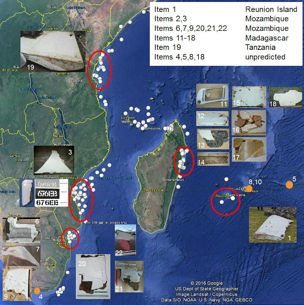
On July 29, 2015, more than 16 months after the flight disappeared, a wing section called a flaperon washed up on Reunion Island in the western Indian Ocean. This has been confirmed as originating from the MH370 aircraft.
More aircraft debris has been found in the western Indian Ocean: in Mauritius, Tanzania, Rodrigues, Mauritius again, Madagascar, Mozambique and South Africa.
The ATSB undertook a first principles review in November 2016 and based on additional information, particularly from oceanographic drift modelling, concluded that the 120,000 square kilometre search area was unlikely to contain the missing aircraft.
The ATSB also reported that oceanographic debris modelling undertaken by the CSIRO provided strong evidence that the aircraft was most likely to be located to the north of the search area between latitudes 32.5°S and 36°S along the 7th arc within an area of 25,000 square kilometres close to 35°S.
CSIRO released an updated report on April 21 this year with more refined modelling of the flaperon, based on field tests using an actual Boeing 777 flaperon.
This confirmed the conclusion of the first principles review that the crash site is most likely at the southern end of the 25,000 square kilometre region near 35°S. CSIRO defines the error to be within 100km, which is 1° of latitude.
More evidence
Many independent oceanographic studies using different oceanographic (for current fields) and debris transport models have reached similar conclusions with respect to the location of the crash site.
They have all concluded that the crash site is not in the initial 120,000 square kilometre search area, but further north. A European study placed the crash site between 28°S and 35°S, and our study puts it between 28°S and 33°S.
Since the flaperon was discovered on Reunion Island, more pieces of debris have been found – many confirmed to be from MH370 and others to be from a Boeing 777, the aircraft design used for the flight.
The locations of these debris finds are consistent with oceanographic drift modelling. These predictions guided the discovery of many pieces of debris by US lawyer and amateur investigator Blaine Gibson and next-of-kin in Mozambique and Madagascar.
Of the 22 pieces of debris found the location of 18 were predicted by our UWA model. Those not predicted were in Mauritius and Rodrigues Islands which may not be well represented in the oceanographic model. The debris origin for this was at 96.5°E and 32.5°S along the 7th arc.
Thus based on the results of several independent oceanographic drift modelling studies that have used different oceanographic models to predict the current fields and including different debris transport modules, all have come to a similar conclusion to that of the ATSB’s first-principles review: the crash site is along the 7th arc 32.5°S and 36°S within an area of 25,000 square kilometres.
This area is immediately to the north of the 120,000 square kilometre region that has already been searched.
From an oceanographic viewpoint this is the best “credible new information” the search authorities have asked for that could be provided on the location of the MH370 crash site.
As oceanographers we have been using drift modelling for variety of applications for more than two decades and have high confidence in the results.