
Recent images of the devastating flash floods caused by Storm Daniel in Greece hit close to home literally and figuratively. As a Greek who has completed a PhD and worked for the past eight years on flash floods, the scenes unfolding across my homeland are painfully real: a stark reminder of the broader environmental challenges we face both on a local and a global scale.
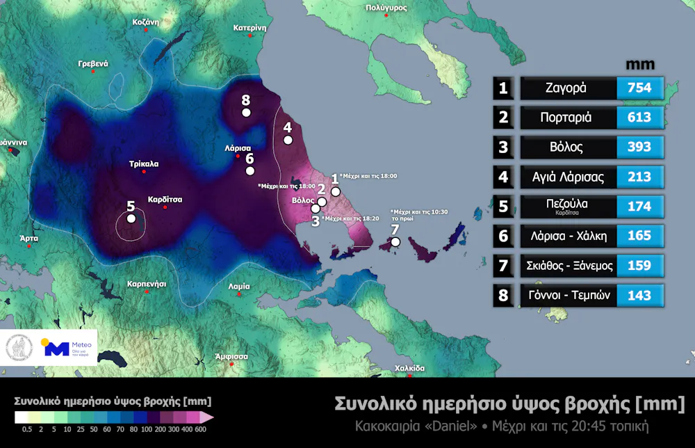
These unprecedented flash floods were triggered by rainfall from the arrival of Storm Daniel on Monday September 4 which also affected Turkey and Bulgaria. The following day, in the village of Zagora, a record-breaking 754mm of rain fell in just 18 hours, leaving parts of the region of Thessaly in crisis and unable to respond.
To put this in perspective, London gets about 585mm of rain over the course of a year while Thessaly gets 495mm, meaning that on Tuesday September 5, about 1.5 years’ worth of rain fell in 18 hours. Imagine the most torrential rain you have ever experienced, perhaps a cloudburst lasting 20 minutes or so. Now imagine it raining that hard but without pause for an entire day.
Flash flooding is short in duration but extremely intense, and typically happens within six hours of heavy rainfall. Unlike regular floods, which develop more slowly and can be predicted in advance, flash floods catch people off guard due to their rapid onset and are rarely recorded in the field.
Catastrophic effects
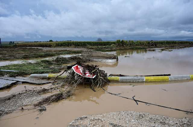
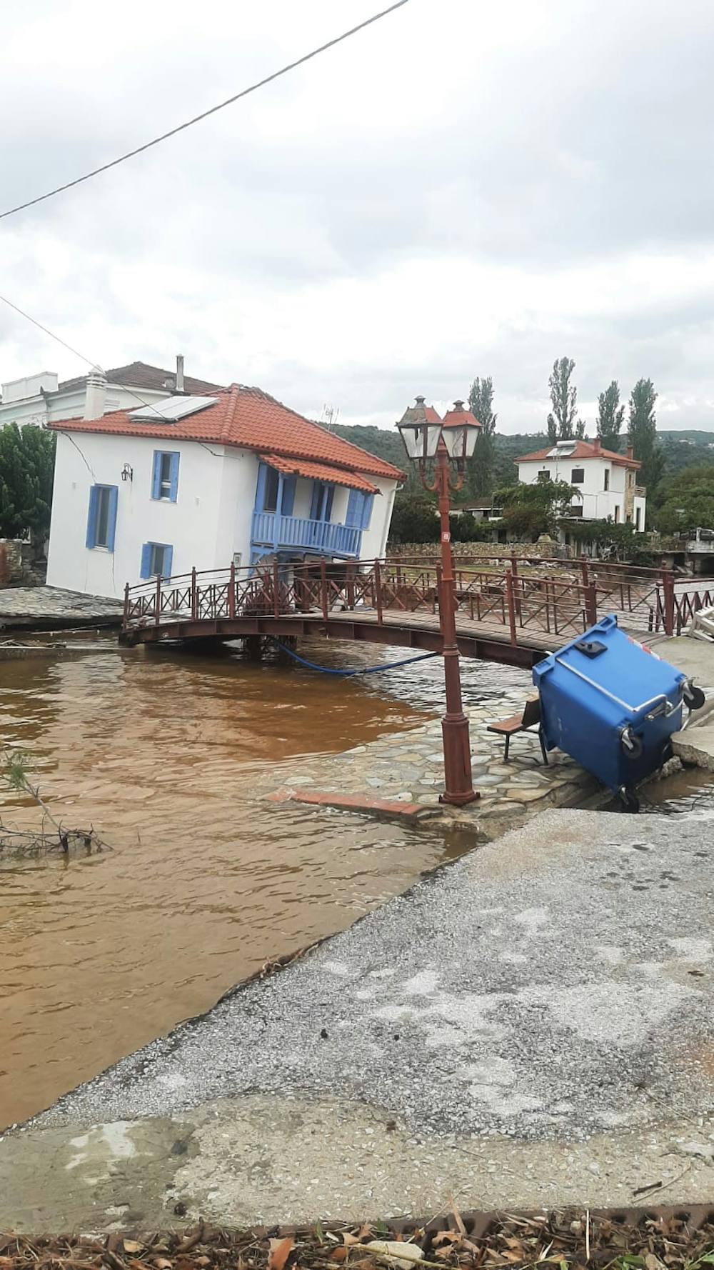
Across the three affected countries the floods have killed at least 18 people, with many others seeking refuge on their rooftops. There are ongoing power and water outages, infrastructure has been damaged, houses and even entire villages have been completely submerged.
I asked Andrew Barnes, an academic at the University of Bath with expertise in using AI to analyse extreme events why this event was so exceptional. He told me that throughout Tuesday, a strong low-pressure centre formed across the south of Greece creating a large rotating weather system known as a cyclone.
This cyclone carried large rain clouds from both the Mediterranean and Aegean Sea between Greece and Turkey. But it did not dissipate, and instead its low-pressure centre moved southwest and settled just south of Italy, with its bands of rain clouds also moving south and covering most of mainland Greece.
Trending across the region
It is crucial to emphasise that flash floods are not confined to Greece alone. They are in fact part of a broader pattern of extreme weather that has become more intense and frequent across the Mediterranean region.
Researchers who looked at 150 years of flood data in the Mediterranean found that most were flash floods, with their highest occurrence during the summer and autumn months. The region is particularly susceptible to these floods due to the combined effects of climate change and urbanisation. The latter has increased urban development in flood-prone areas and increased impervious surfaces (like roads and pavements), preventing the natural absorption of water into the ground.
The Intergovernmental Panel on Climate Change’s chapter on the Mediterranean region issued a warning that extreme rainfall events are going to occur more often and be even more intense, elevating the risk of flash floods. This warning, in combination with records of flash floods in 2023 in Spain, Italy, Turkey, Bulgaria, France and Greece, underscores the urgent need for proactive measures to address these climate-related challenges.
Research is advancing
Flash floods might be rare, but they are severe enough to be a matter of significant concern. Fortunately, research has advanced considerably in recent years. We’re now better able to forecast when flash floods might happen, which areas might be susceptible, and to assess their impact in real-time.
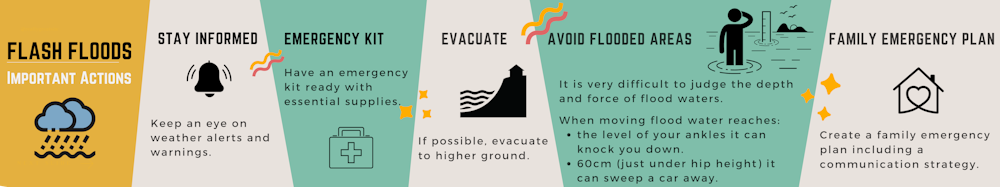
My colleagues and I are working on a project that combines historical documentary sources and modern hydraulic modelling. This way we can shed light on past floods and better understand the risks they pose, helping us design effective mitigation strategies for the future. Practically, in the case of a flash flood some basic but very important actions can be found on the poster below.
A complete eradication of flooding is neither technically feasible nor economically affordable. Instead on a larger scale it is key to start identifying flash-flood prone areas especially in catchments with historical flash floods. We should then focus on advocating for climate action and resilience measures, which can be anything from “hard” defences like new flood walls, through to policies and better public awareness of the risks. Only this will offer hope of a safer and more resilient future.

Don’t have time to read about climate change as much as you’d like?
Get a weekly roundup in your inbox instead. Every Wednesday, The Conversation’s environment editor writes Imagine, a short email that goes a little deeper into just one climate issue. Join the 20,000+ readers who’ve subscribed so far.