

When people ask us about our research, we answer: we are working on land-use planning. We rarely receive another question. Most of the time, after seconds of embarrassed silence, people move swiftly to another topic.
Land use planning (LUP) indeed seems the most boring topic for research: dry, bureaucratic and administrative, probably some kind of horrible desk study. However, when you go to Mamberamo, in Papua, everything is different. Far from being a “boring concept”, LUP in fact helps us to understand people’s livelihoods, what makes them react and adapt, and how they can influence their future.
In Mamberamo, even if many people do not know much about land-use planning, all of them – villagers, migrants, local government staff, NGO members and private sector workers – know how to map territory, zone it, negotiate on rights and activities, define limits, boundaries and access. It does not take long to discover that land-use planning is everywhere and that everyone is talking about it, some way or another.
Mamberamo is a huge watershed, covered by about 8 million hectares of natural forests in different ecosystems: mountains, hills, swamps, mangroves and lowlands. Mamberamo is an approximate 800-kilometre long river made of two rivers, Tariku and Taritatu, flowing from the Jayawijaya Mountains to the north coast of Papua and the Pacific Ocean.
In such an isolated region, access is key to land management and LUP. Mamberamo River is the main way of getting to the area. It is also the main source of locals’ livelihoods. The river is a highway and transportation is by small and motorised pirogues.
When you travel from upstream to the ocean, you cross a diversity of landscapes and ecosystems, and as many different ethnic groups as there are villages on the riverbanks. LUP needs to capture the complexity of local land use and the diversity of landscapes, to be locally relevant.
Upstream, the river meanders in a swamp, because there is no solid ground to provide direction to the river: it is all mud. This is where the largest sago forests are found, and where Papasena village stands. Villagers catch fish for food and for cash, and extract starch from natural and planted sago. This is why they want to keep this area as a reserve for extraction.
From Papasena, Mamberamo River enters a hilly and mountainous corridor that turns into a straight line for 130 kilometres. You need to pass at least three rapids to reach calmer waters and villages located not far from the water highway.

Higher in the mountains, between Mamberamo and its parallel river, Apawer, some villages such as Metaweja, are far from the main water highway. To get to them, you must walk by following stony riverbeds for days.
If you continue downstream to the north, you will reach the end of the hilly corridor and follow the meanders of the Mamberamo River again, passing nearby the fishy Lake Rombebai, and crossing the mangrove of Yoke on the northern coast. In the mangrove, villages are built on stilts over the water and villagers look for salt and freshwater fish, crab, shrimp and shellfish.
The main demand from all villagers in Mamberamo is better ways to get around. All villages but one (Burmeso, which just became the new capital of the regency) struggle to make long and expensive trips to reach the regency’s capital. Villagers are asking to ease access with roads, airstrips and channels, to create shortcuts in the meanders of Mamberamo River.
For years, an electric dam was planned to cut the straight line that the river forms. If it officially becomes a part of the new LUP, the dam would directly affect Kwerba and Burmeso villages, among others. Mining companies are also pressing the local government to allow them to exploit coal. One of the largest logging concessions in Indonesia (660,000 hectares) is already operating in and around Burmeso.

The river separates the watershed in two parts. The west part is a production forest, where development activities are permitted. But all the villages located on the east side are part of a large protected area (2 million hectares).
The Mamberamo Foja Wildlife Reserve became famous after the discoveries of a “lost paradise” – a sanctuary for many new species of animals and plants. Conservation institutions, through LUP, try to keep this area untouched. However, villagers living in the protected area, long before its boundaries were officially drawn, disagree. They feel the situation is unfair, when access to infrastructure and development depends on where the village stands in the watershed.
LUP is about understanding issues on access, on zoning, on resources management, and should take into account the needs and concerns of local people, among others. But we need to develop clear tools to clarify issues and negotiate.
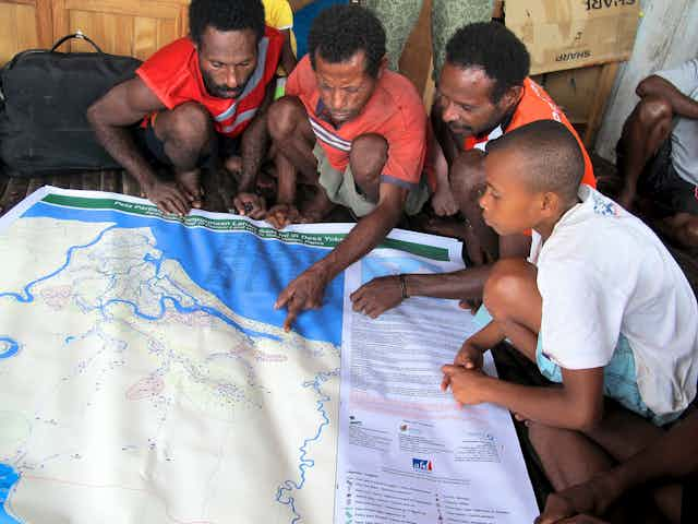
We developed participatory maps with local people to visualise their expectations in terms of land management and development. The maps were at a scale allowing comparison with existing official maps.
We were surprised by the enthusiasm not only from government officials, who indeed needed these maps for developing land-use strategies, but also from the local people, who saw in them a powerful negotiation tool.
Local people quickly understood the potential of these maps to send clear messages about their needs and aspirations to the local government and decision-makers. With confidence and skill they drew the limits of their territory and showed important places in their landscape such as sacred areas, saltwater sources, lakes rich in crocodiles and places for hunting; places that were originally planned for road development and airstrip construction.
So, LUP is boring? We don’t think so.
This research involved collaboration between three institutions – the Center for International Forestry Research, Centre de coopération Internationale en Recherche Agronomique pour le Développement and Conservation International Indonesia – and was financially supported by Agence Française pour de Développement.