


The Bureau of Meteorology has confirmed 2013 as Australia’s hottest year since records began in 1910.
Average temperatures over the continent have been 1.2C above the 1961-1990 average, breaking the previous record set in 2005 by 0.17C. It was also the hottest year on record for South Australia, Western Australia and the Northern Territory. The other states - Queensland, New South Wales, Victoria and Tasmania – recorded above-average temperatures that rank in their top four hottest years.
Off to a hot start, and no El Niño
The year got off to an exceptionally hot start with a heatwave that spanned most of the continent during the first three weeks of January. Numerous locations experienced their highest temperatures on record during this period, including Hobart (41.8C on January 4) and Sydney (45.8C on January 18).
Moomba’s 49.6C on January 12 was the highest recorded temperature anywhere in Australia since 1998 and the highest in South Australia since 1960.
Nationally, January 7 was Australia’s hottest day on record. January was the hottest month on record and the summer of 2012-13 was the nation’s hottest summer.
The record year wasn’t simply a result of a hot January. Above average temperatures were unusually persistent throughout 2013, particularly between July and October. The unusual heat peaked in September when national mean temperatures were 2.7C above average, more than a degree above any previous September and further above average than any previous month in Australia’s climate history. Many parts of the central and eastern interior were as warm in September as they would be in an average November.

Every month of 2013 had national average temperatures at least 0.5°C above normal. Only in the second half of June did a spell of below-average national temperatures last for more than a week. The only below-average monthly temperatures recorded for any state or territory occurred in Tasmania in April, Victoria and Tasmania in November, and the Northern Territory in December.
Annual average temperatures were above normal over the entire continent, but the heat was particularly significant over the central continent, stretching from western Queensland across outback South Australia and the southern Northern Territory, into the Nullarbor in Western Australia.
Over this region, temperatures in 2013 were 1.5C to 2.0C above average, and many records were set across a range of periods. Temperatures were closest to normal along the east coast (including Tasmania) and adjacent ranges, as well as the northern tropics – but even in those locations temperatures were generally 0.5C to 1.0C warmer than average.
Most of the previous notably hot years in Australia have come when there has been El Niño or near-El Niño conditions in the tropical Pacific. Following the breakdown of La Niña in the first half of 2012 (and a period of relatively cooler temperatures traditionally associated with this climatic state) conditions have remained close to neutral all year with neither an El Niño nor La Niña state in the tropical Pacific.
The presence of record temperatures without the climatic influence of an El Niño makes the 2013 Australian temperatures especially significant.
Rainfall was near average, except here and there
It was a mixed bag for Australian rainfall in 2013. On a nationally averaged basis, it was close to normal (8% below average), but there were some big variations.
The contrast was especially striking in Queensland and northern New South Wales. It was a wet year on most of the east coast. This was thanks in part to (ex-)Tropical Cyclone Oswald, which tracked down the coast in January and caused heavy rain and widespread flooding from northern Queensland all the way south to Sydney.
Oswald’s rains had little effect west of the Great Dividing Range, and areas more than 300 kilometres inland in Queensland suffered from drought for most of the year. Mount Isa had its driest year on record with only 86 millimetres.

It was a wet year over many northern and interior parts of Western Australia. The effects of tropical cyclones early in the year were followed by regular northwest cloud-band activity between May and mid-July, when waters northwest of the continent were unusually warm as part of a negative phase of the Indian Ocean Dipole. Heavy rains at the end of the year, associated with Tropical Cyclone Christine, were enough to take Port Hedland beyond its previous wettest year.
Over much of southern coastal Australia, rainfall was fairly close to normal. From July to October, unusually strong and persistent westerly winds over southern Australia brought heavy rain to the southern coastal fringe, especially Tasmania, but very dry conditions to New South Wales and Queensland.
2013 - the global picture
Globally, it was another warm year. As of the end of November, global temperatures were 0.49C above average, ranking 2013 as the 6th hottest year on record. Thirteen of the 14 hottest years on record have occurred since 2001.
Other parts of the world to experience their warmest year on record in 2013 included the tropical North Pacific region around and east of the Philippines, along with parts of central Asia.
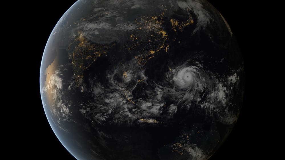
The exceptionally warm waters in the western North Pacific contributed to a very active tropical cyclone season in the region, especially in October and November. In those months there were seven super typhoons (the equivalent of a category 4 or 5 tropical cyclone in Australia) in as many weeks.
The most significant of these was Typhoon Haiyan, one of the most intense tropical cyclones ever to make landfall. It caused massive destruction and claimed thousands of lives in the Philippines in early November.
Overall, after three fairly quiet years, global tropical cyclone activity was slightly above normal in 2013.
In contrast to the record hot conditions in Australia, 2013 temperatures were near normal in the United States. In 2012 it was the other way around, with the United States having a record warm year.
It was also less warm than some recent years at high latitudes in the Northern Hemisphere. Arctic sea ice melted to a lesser extent than in 2012, although the total sea ice extent was still lower than in any year before 2007.
At the other end of the globe, the extent of Antarctic sea ice reached record-high levels in September. Compared to the Arctic, Antarctic sea-ice extent is not as strongly influenced by recent global warming, with year-to-year climate variability still playing a large role in year-to-year changes in Antarctic sea-ice extent.
In northern and central Europe a hot summer followed a cold spring. It was also an exceptionally hot summer in parts of eastern Asia, especially eastern China, the Korean Peninsula and Japan.
Large fluctuations between extreme heat and cold were a feature of South America in late winter and spring; as one example, snow fell around the Argentinian city of Cordoba in mid-September, only days after it had reached 40°C. At the end of the year an exceptionally prolonged heatwave set many records in northern and central Argentina, including for the capital, Buenos Aires.
Extreme rainfall was not as much of a feature of 2013 globally as it has been in some recent years, though monsoon season rainfall was generally above normal both in the Indian subcontinent and the Sahel region of west and central Africa.
In addition to western Queensland, regions to experience significant drought in 2013 included parts of southern Africa, northeast Brazil, and the southwest United States. California had its driest year on record and San Francisco recorded only 86 millimetres of rain for the year, less than 20% of average and less than half the previous record low.
It has been a warm finish to the year, including the world’s warmest November on record. While there have been some large fluctuations in temperature – in regions such as the Middle East and northern Scandinavia, record or near-record warmth and cold for this time of year have happened within days of each other in recent weeks – the overall picture is one of temperatures well above average.
A warming trend
The temperatures of 2013, both in Australia and globally, are consistent with a long-term warming of 0.8 to 0.9°C over the last century, much of it in the last 50 years.
As temperatures continue to warm, we can expect new records to occur more frequently. The potential for a new global record at some point in the next decade is high – most likely the next time there is a significant El Niño event when warmer temperatures have traditionally been recorded.