
Recently NASA reported that this year’s maximum wintertime extent of Antarctic sea ice was the largest on record, even greater than the previous year’s record.
This is understandably at odds with the public’s perception of how polar ice should respond to a warming climate, given the dramatic headlines of severe decline in Arctic summertime extent. But the “paradox of Antarctic sea ice” has been on climate scientists’ minds for some time.
Continental v. sea ice
First off, sea ice is different to the “continental ice” associated with polar ice caps, glaciers, ice shelves and icebergs. Continental ice is formed by the gradual deposition, build up and compaction of snow, resulting in ice that is hundreds to thousands of metres thick, storing and releasing freshwater that influences global sea-level over thousands of years.
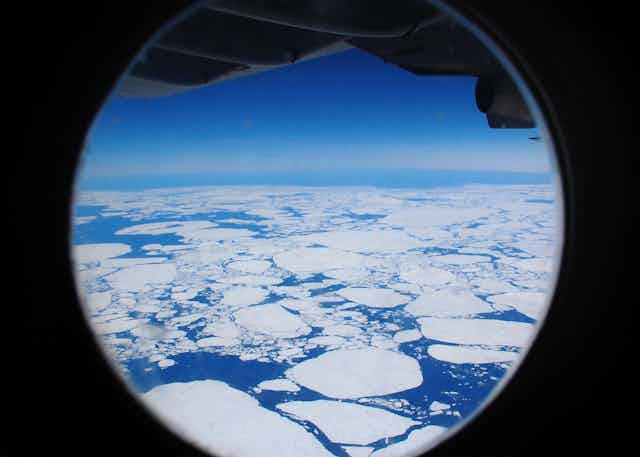
Sea ice, though equally important to the climate system, is completely different. It is the thin layer (typically 1-2m) of ice that forms on the surface of the ocean when the latter is sufficiently cooled enough by the atmosphere.
From there sea ice can move with the winds and currents, continuing to grow both by freezing and through collisions (between the floes that make up the ice cover). When the atmosphere, and/or ocean is suitably warm again, such as in spring or if the sea ice has moved sufficiently towards the equator, then the sea ice melts again.
Antarctic v. Arctic
Secondly, we need to understand that the Arctic and Antarctic climate systems are very different, particularly in sea ice.
In the Arctic, sea ice forms in an ocean roughly centred on the North Pole that is surrounded by continents. A relatively large (though diminishing) proportion of the ice persists over multiple years before ultimately departing for warmer latitudes through exit points such as Fram Strait between Greenland and Svalbard.
In the south, on the other hand, sea ice forms outwards from the continental Antarctic Ice Sheet, where it is exposed to and strongly influenced by the winds and waters of the Southern Ocean. Here, there is a much stronger seasonal ebb and flow to sea ice coverage as over 80% of the sea ice area grows each autumn-winter and decays each spring-summer. This annual expansion-contraction from about 4 to 19 million square kms is one of the greatest seasonal changes on the Earth’s surface.
Area v. volume
Finally we need to remember that “extent” or “areal coverage” is only one way with which we monitor and study sea ice.
Sea ice turns out to be a very complex and variable medium that is very difficult to observe over large-scales. It is also constantly moving and restructuring. Until we achieve the “holy grail” of monitoring total sea ice volume from space and how it changes over time (and there are great steps towards this with European Space Agency’s environmental research satellite CryoSat-II), we are limited to interpreting its global behaviour through area.
What happened this winter?
This winter, the maximum total Antarctic sea ice extent was reported to be 19.47 million square kilometres, which is 3.6% above the winter average calculated from 1981 to 2010. This continues a trend that is weakly positive and remains in stark contrast to the decline in Arctic summer sea ice extent (2013 was 18% below the mean from 1981-2010).
To further complicate this picture, we find this net increase actually masks strong declines in particular regions around Antarctica, such as in the Bellingshausen Sea, which are on par or greater than those in the Arctic.
So while there is much greater attention given to the Arctic decline and the prediction of “ice-free summers” at the North Pole this century, Antarctic climate scientists still have their work cut out to understand the regional declines amidst the mild “net” expansion occurring in the southern hemisphere.
Here are some of the leading hypotheses currently being explored through a combination of satellite remote sensing, fieldwork in Antarctica and numerical model simulations – to help explain the increasing trend in overall Antarctic sea ice coverage:
Increased westerly winds around the Southern Ocean, linked to changes in the large-scale atmospheric circulation related to ozone depletion, will see greater northward movement of sea ice, and hence extent, of Antarctic sea ice.
Increased precipitation, in the form of either rain or snow, will increase the density stratification between the upper and middle layers of the Southern Ocean. This might reduce the oceanic heat transfer from relatively warm waters at below the surface layer, and therefore enhancing conditions at the surface for sea ice.
Similarly, a freshening of the surface layers from this precipitation would also increase the local freezing point of sea ice formation.
Another potential source of cooling and freshening in the upper ocean around Antarctica is increased melting of Antarctic continental ice, through ocean/ice shelf interaction and iceberg decay.
The observed changes in sea ice extent could be influenced by a combination of all these factors and still fall within the bounds of natural variability.
The take home messages is that while the increase in total Antarctic sea ice area is relatively minor compared to the Arctic, it masks the fact that some regions are in strong decline. Given the complex interactions of winds and currents driving patterns of sea ice variability and change in the Southern Ocean climate system, this is not unexpected.
But it is still fascinating to study.