

Another series of strong earthquakes has struck central Italy, with schools and the metro evacuated in Rome. At least four earthquakes with a magnitude greater than 5 have followed in a few hours, with their epicentres near the town of Amatrice.
Thankfully, there have been no reported deaths. But this series of earthquakes adds to those that struck the same region over the past year and have left many Italians feeling helpless and traumatised.
On August 24 2016, a strong earthquake of magnitude 6.1 hit central Italy in the middle of the night. It killed 300 people and almost entirely destroyed the town of Amatrice. Two months later, on October 26, two new earthquakes of magnitudes 5.5 and 5.9 hit the same region – in the Norcia area – again terrifying inhabitants.
Four days later, an even stronger shock of magnitude 6.5 struck the traumatised populations again. Miraculously, there were no victims – but the damage was enormous.
What happened? Why is the Earth’s machinery striking this beautiful and peaceful region of Central Italy again and again?
Cascading earthquakes
We have long known that any earthquake induces a long series of smaller earthquakes, which are known as aftershocks. But, in this case, we are not facing aftershocks. These are large new earthquakes on new faults.
In the Amatrice-Norcia region, it seems that the earthquakes cascaded along the huge fault system to the west of the Bove, Vettore and Gorzano mountain. About 70km in length, this fault system – named “Amatrice-Monte Vettore” – is one of the largest in Italy. And one of those across which the Earth’s crust is stretching apart.
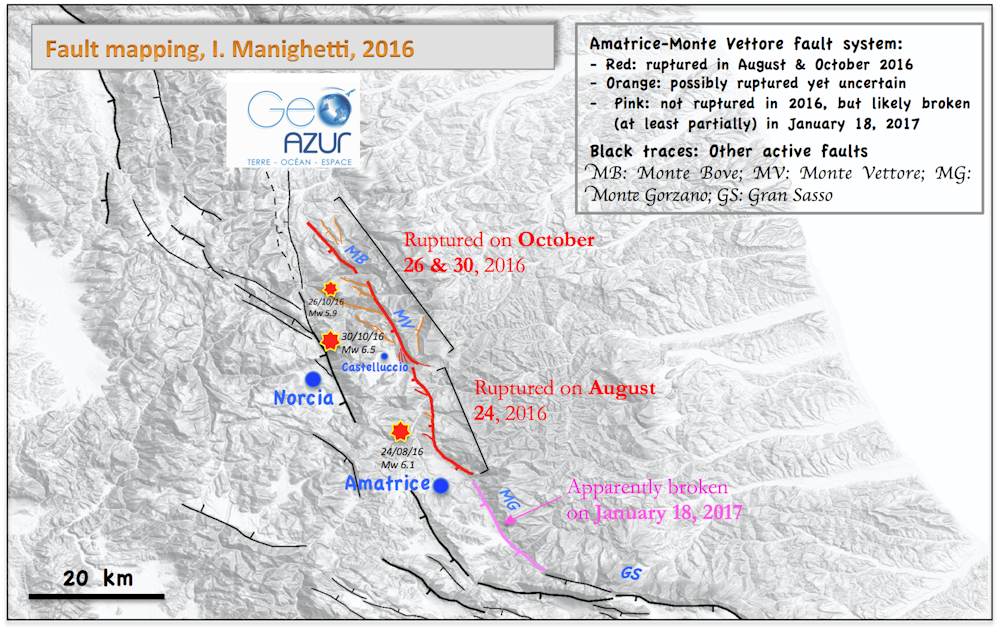
A closer examination of the Amatrice-Monte Vettore fault system shows that it is actually divided into four principal, 10 to 20km-long sections, called “segments” (see figure). These four segments are separated by a gap of a few kilometres or by pronounced bends. The Amatrice-Monte Vettore fault trace is thus jerking from one of its segments to the next.
Understanding faults
The undulations and disruptions of segmented faults worldwide have recently been analysed. Independent of their size and location over the world, most faults are divided into a similar number of principal segments, generally three to four.
These segments are separated with specific zones – which fault specialists call “inter-segments”. Their mechanical properties differ from those of the segments. Yet the mechanical properties of the inter-segments are modified as the number of earthquakes on the overall fault increases over time.
When a fault is immature – that is, producing earthquakes for less than a few millions years – its segments are clearly disconnected so that it is mechanically difficult for an earthquake rupture to travel from one segment to the next. But as the fault produces more and more earthquakes over time and hence becomes more “mature”, its segments connect more and more to each other. When the segment connection is more complete, a new rupture can progress forward more easily along the fault.
The Amatrice-Monte Vettore fault is immature, as are most faults in Italy. It is likely that its segmentation and immaturity have been a major cause of the cascading earthquakes.
On August 24, the first strong earthquake broke the central segment of the fault. This energetic, single-segment rupture is likely to have then provoked the breakage of the other two segments further north.
By October 30, one segment, in the south, remained unbroken. This southern segment seems to have broken today, at least partially, since the four strong earthquakes that just occurred on January 18 have their hypocentre located in the south of the system, due west of the southern segment of the Amatrice-Monte Vettore fault.
The Amatrice-Monte Vettore fault might thus be now completely or almost completely broken. As it had been three centuries ago: in 1703, a cascade of earthquakes similar to the present one occurred and broke, in 19 days, the totality of the Amatrice-Monte Vettore fault system, killing about 10,000 people at the time.
Should we be worried about more breakage of the Amatrice-Monte Vettore fault or of nearby faults? Prehistoric earthquakes may hold part of the answer.
Warnings from history
Several methods exist to recover information on the most recent prehistoric earthquakes – quakes that occurred on worldwide before we were there to feel them.
We have developed and applied one of these methods to about ten faults located in the Fucino area, just south of the Amatrice region. There, the Avezzano earthquake killed 30,000 people in 1915.
The results are stunning: more than 30 large earthquakes, of magnitudes 6 to 6.7, broke the Fucino faults over the past 15,000 of years. Each large “earthquake” identified by the method was actually not a single event, but a cascade of several strong earthquakes that followed along a fault, probably over a few years or decades, to break it entirely. These cascades recall the one we are seeing today.
The vertical displacements produced at surface by the prehistoric earthquakes were up to 2-3 metres, just as those produced by the strongest October 30 earthquake of the 2016-2017 cascade (see picture below).

The picture above shows how the Monte Vettore fault has created a steep high cliff over time. The fault plane goes deep below the surface, to about 10-15km deep. It is at such a depth where large earthquakes generally begin. When a large earthquake occurs, it makes rocks slide vertically on either side of the fault plane. One side, on the left of the picture, is brutally moved upward, and its shallowest part is pulled up from the Earth, forming here a 2m high fresh wall (where people stand).
Along each fault, each cascade of prehistoric earthquakes was shortly followed by one or two other similar cascades which intensely shook the fault over a period of a few hundred years.
All of the ten faults we analysed ruptured in repeated earthquake cascades at about the same times: 11,000 years ago, then 4,500 years ago, and more recently, around the fifth century.
These results markedly change our thinking about earthquakes. We have long believed that the occurrence of one large earthquake in a region represented the Earth relaxing, and as such, the promise of a subsequent period of calm.
This might not be correct: a large earthquake can be followed by strong shocks, cascading along a fault until they succeed in breaking it entirely. These cascades can last days to years. They can also repeat over centuries. They can even occur at the same time as cascades on different faults.
Faults prone to producing cascading earthquakes are numerous in Italy as in other regions worldwide. Seismic hazard is thus high in most of Italy, and is still serious in the Amatrice-Norcia region and nearby areas, as recent events demonstrated.
The southern segment of the Amatrice-Monte Vettore fault might have broken today, possibly completing the rupture of the entire system. But the hazard is not over because other faults exist around the Amatrice-Monte Vettore system: in the north, several faults have not ruptured for centuries; in the west, where there are other faults that are likely to be mechanically connected with the Amatrice-Monte Vettore system; and in the south, where the huge Gran Sasso fault system has not ruptured for centuries.
We can do nothing to stop cascading earthquakes. But it is important to be aware that they might occur, in Italy and elsewhere.
The fault mapping in this article has been done by the author based on available documents and complementary analysis of satellite Google Earth images and SRTM topographic data. The rupture of the segments is inferred from seismological, geodetic and field observation data mainly reported by INGV Italy, CNRS France, and COMET UK, complemented with the author’s preliminary analysis of Pleiades satellite images. The rupture mapping will be refined in the forthcoming months while data analyses are completed.