
Some years ago, I found myself making my way up the narrow stairs of a Learjet on a sultry runway in a deserted airport near the South Africa-Mozambique border. The humidity was there to taste – the air thick with it.
The weather radar was showing a fast-developing thundercloud. Our mission was to fly through the most active part of the storm, measure it, fly through again while dumping a bin load of dry ice, turn hard and fly through for a final measurement.
The inside of the Learjet resembled a food blender, so severe was the turbulence. Thousands of meters below, a smaller plane would be threading through the storm downdrafts measuring the rain. It isn’t something you do every day although the saucer-sized hail dents on the wings of the Learjet told of its many prior engagements.
Apart from the fun of flying through the core of a thunderstorm in a Learjet, I didn’t think much about the time I was lucky enough to be part of that project. Until I heard about the recent freak storm in Dubai.
The project I was part of, neatly named Rain (Rain Augmentation in Nelspruit), was a cloud seeding experiment several years in the making. Cloud seeding involves adding tiny particles into a cloud in order to give moisture something to attach to and form droplets. Gradually those droplets merge and become heavy enough to fall as rain. In theory, the “seeeded” clouds will grow more droplets suitable for rain.
No one flight is proof of seeding having been effective. It can’t be. There is no identical cloud with which to compare the outcome of having seeded a particular cloud. It is therefore necessary to fly a lot of missions and to measure, but not seed, half of them thereby creating a data set for the experiment itself (seeded clouds) and the control (unseeded clouds).
Statistical analysis of the results from Rain was rigorous to say the least. After several years of trying, modification of rain rates from some storms was successful, although it would never be possible to prove that any one storm had been changed.
A perfect storm
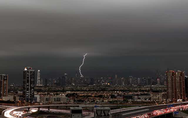
Early on Tuesday morning, April 16, the chat network of my school class which is replete with global insights after 40 years of dispersion, lit up with reports of unprecedented rain from Brendan in Bahrain and Ant in Dubai. Ant is a pilot and was flying out of Dubai that morning. He duly relayed photographs of his flight over the saturated desert.

Parts of the Arabian Peninsula received 18 months of rainfall in 24 hours that Tuesday. The airport looked more like a harbour. Being the weather-man in the chat group, I looked at the satellite and the forecast model data. What I saw were the ingredients of a perfect storm.
What normally keeps the old deserts, such as those of the Arabian Peninsula, so very dry is persistent and intense sinking of air – the very opposite of what is required for rain. The sinking air is bone dry, having come from the cold, top of the atmosphere, and is compressed and warmed as it descends. It arrives near the surface like a hairdryer.
Below this layer, especially in deserts close to warm oceans, evaporation is plentiful. But that humidity is kept captive by the sinking air above. It is a cauldron with the lid firmly on.
What took that lid off the cauldron on 16 April was a high-altitude jet stream unusually far south. In fact two jet streams, the subtropical jet and the polar jet that had joined forces and left behind a cut-off circulation of imported, cooler air. The sinking air, along with the cauldron lid, was gone.
Meanwhile a feed of moisture laden air was accelerating in from the northern tropical Indian Ocean and converging over the desert. Dew point temperatures over the UAE were similar to those normally found in the rainforests of the Congo basin.
Under these conditions, thunderstorms develop very readily and in this case a special kind of storm, a mesoscale convective system, built and sustained itself for many hours. Infrared satellite data showed it to be about the size of France.
Cloud seeding not to blame
The power, intensity and organisation of a storm like this is hard to fathom. What surprised me, though, was not the majesty of nature, but an emerging set of reports blaming the ensuing rains on cloud seeding. One broadsheet even insinuated the University of Reading, a powerhouse of meteorological expertise, was responsible.
It turns out the UAE has been running a cloud seeding project, UAE Research Program for Rain Enhancement Science, for several years. Their approach is to fire hygroscopic (water-attracting) salt flares from aircraft into warm cumuliform clouds. The idea, similar to the Rain project I once worked on, is to promote the growth of cloud droplets and thereby rainfall. Bigger droplets fall out more easily.
So could seeding have built a huge storm system the size of France? Let’s be clear, that would be like a breeze stopping an intercity train going at full tilt. And the seeding flights had not happened that day either. The kind of deep, large-scale clouds formed on April 16 are not the target of the experiment.
The interesting thing is that humans have a hard time coming to terms with the fact that 2,400 gigatonnes of carbon (our total emissions since pre-industrial times) might make a difference to climate, but very readily get behind the idea of a few hygroscopic flares making 18 months worth of rain fall in a day.

Don’t have time to read about climate change as much as you’d like?
Get a weekly roundup in your inbox instead. Every Wednesday, The Conversation’s environment editor writes Imagine, a short email that goes a little deeper into just one climate issue. Join the 30,000+ readers who’ve subscribed so far.