
Antarctica’s sea ice is changing in ways that scientists and climate models didn’t predict. Each of the past three years has broken the record for sea ice extent, continuing an increasing trend over the past three decades.
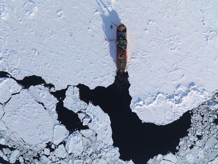
It’s also causing headaches for national Antarctic programs. More sea ice extent in some regions is creating a challenge for ships, and in some cases causing a complete rethink of how Antarctic stations are resupplied.
At an international workshop in Hobart this week there was a “meeting of minds” between the international sea ice research community and the Council of Managers of National Antarctic Programs (COMNAP), who have responsibility for managing and re-supplying Antarctic stations.
The goal: to improve sea ice analysis and forecasting services to support Antarctic operations.
The long term trend
The maximum extent of Antarctic sea ice, which occurs in September each year, has increased over the past 35 years by about 1% per decade.
However, this net increase in sea ice extent is small compared with some much larger regional changes.
West of the Antarctic Peninsula, for example, the sea ice is present for three months less each year than in 1980, while further west in the Ross Sea the sea ice is present for three months longer.
Around much of the east Antarctic coastline, where Australia’s three research stations are located, the changes in extent have been more modest, with small increases and decreases noticed in different areas.
A fickle forecast
Sea ice is notoriously difficult to model or “forecast” because it sits at the boundary of the ocean and atmosphere. Wind, waves, temperature, ocean currents and tides all make sea ice difficult to predict.
Small errors in any one of these variables in a forecast model can quickly translate into large errors in sea ice, and from the perspective of a ship’s captain, receiving wrong information is worse than receiving no information.
Hence, the science community is currently focused on providing “now-cast” information, based on satellite images, in near-real time, to help with vessel navigation, while aspiring to develop forecasting tools that can be relied upon. The latter requires high resolution, regional models, with good data assimilation (which is difficult in such a data sparse region). It also requires a concerted effort by scientists and national programs.
At some of the Antarctic stations, local effects have been the main driver of changes in sea ice. Icebergs (often tens of kilometres across), which break off the Antarctic continent and drift around the Antarctic coast, can get stuck on shallow parts of the continental shelf.
Sea ice, which forms by freezing sea water, can then build up around these icebergs creating an impenetrable icy barrier to shipping, and making it impossible for ships to reach the Antarctic stations. This has happened to both the Australian and French Antarctic programs in recent years, at Mawson and Dumont d’Urville, respectively, causing a rethink of how supplies and people are moved from ship to shore.
This has variously involved tractor trains across the ice towing bladders of fuel and supplies, to the more frequent use of helicopters.

Blowing in the wind
Scientists now know that the large changes in sea ice extent around Antarctica have been largely driven by changes in the wind.
The band of westerlies that persistently blow around the Antarctic continent have strengthened as a result of changes in atmospheric chemistry (driven by ozone depletion in the stratosphere and the input of greenhouse gases) as well as complex interactions between other modes of climate variability, including El Niño and the Southern Annular Mode.
The sea ice around Antarctica is pushed by the wind, which ultimately determines how far it extends from the coast, so stronger southerly winds push ice further away from the coast (as in the Ross Sea), and northerly winds drive the ice towards the coast (as in the West Peninsula region).
There is also a compounding temperature effect because the southerly winds are much colder and help generate more sea ice, as well as pushing it away from the coast, while northerly winds are relatively warmer.
Overall, the changing patterns of sea ice are complex, but there is no doubt that Antarctic operations are being challenged. The stronger winds may also be generating thicker sea ice, by pushing ice floes together to form pressure ridges that may reach several tens of metres thick.
This is highly problematic for shipping, and there is anecdotal evidence it is happening in some regions. Sea ice thickness – unfortunately – remains one of the hardest climate parameters to measure and monitor, although improving satellite technology is providing scientists with new tools.
The innovative use of Autonomous Underwater Vehicles, equipped with upward looking sonar and video capability, is providing new insights into the complex, under-ice world of the Antarctic sea ice zone.
The author delivered a public lecture in Hobart as part of the recent “Sea Ice Challenges” workshop, which is available here.