


The year 2023 has been one of extremes, from heatwaves that baked millions across the globe and made the summer the world’s hottest on record to the fires that forced tens of thousands to evacuate across Western Canada. From the feel of surprising warmth in the mid-winter sun to the crinkle and cracking of leaves dried by drought, you can witness climate change with all of your senses.
Read more: Yellowknife and Kelowna wildfires burn in what is already Canada's worst season on record
Our perception of climate change is shaped by personal experiences of such extremes, and our first-hand climate experiences are rooted in where we live. As a result, there is a profound disconnect between the experiences of those who live in cities far from the planet’s northernmost reaches and those who live in the Arctic, where the climate is changing faster than anywhere else on Earth.
Despite this gulf of experience, there are surprising parallels between Canadian urban cores and northern Arctic islands where the shape of the landscapes hold our shared histories.
Polygons
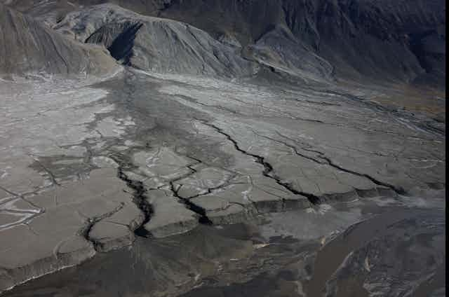
Polygons are perhaps one of the most visually striking features that can be found in the high Arctic. They are vast areas of ground that are patterned by geometric protrusions, 10 to 20 metres in width, rimmed by metre-deep troughs.
From above, the landscape looks like it has been tiled by puzzle pieces as wide as school buses; up close, walking through polygon troughs feels like being an ant wandering the cracks in dried mud.
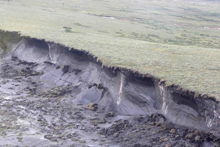
Polygons can form when seasonal temperatures interact with perennially frozen sub-surface soil, known as permafrost. Winter cold first contracts the ground so fiercely that cracks form, penetrating into the frozen sub-surface. These cracks fill with meltwater in spring, and, because permafrost has typically stayed cold year-round, the pools of meltwater freeze, expand and further push apart ground.
Such cracks form troughs that meet others, and since both permafrost and seasons span large areas, so too can fields of polygons.
The topographic pattern of polygons shapes the history of a place. They efficiently organize where and how water moves through the landscape, and as such, they alter more than how the landscape looks: they fundamentally reshape how it functions.
Over time, streams can develop along the angular polygon boundaries where channels erode and deepen as water flows. Deeper channels expose previously-buried permafrost to warm summer air, furthering thaw and intensifying methane emissions as once-frozen organic matter decomposes. Polygons shape where water goes, and, in turn, the water reshapes the world in which it travels.
The impact of polygons persists even after the permafrost has thawed: looking at a map, you can spot where polygons were by the zig-zagging nature of rivers and streams that follow where polygon troughs used to be. Landscapes hold memory.
Urban memories
Cities, too, hold memory. If you live in a larger Canadian city, you live in a place whose character and function have been shaped by transitional patterns that facilitate flow, like in the Arctic. While in the Arctic we can look to polygons to find memory, in cities we can look to streetcars.
Networks of streetcar lines were built in most major North American cities between the late 1800s and the mid 1900s in response to growing populations, from Vancouver to Miami, Toronto and San Francisco. When these streetcars patterned the cityscape, they shaped where people went.
Areas near streetcar stops developed rapidly and reshaped the character of the neighbourhoods themselves. Businesses, services and entertainment emerged and grew along the interconnected corridors that newly criss-crossed cities, and a particular urban vibrance came from the intermingling nature of these places where people could find services and amenities, live and work, gather and stay.

Most streetcars have been removed or replaced across North America since the mid-20th century. However, despite the loss of streetcar lines themselves, neighbourhood character has persisted along the corridors where the lines once were. Zoning laws locked in neighbourhoods just as eroded channels locked in the course of Arctic streams.
In patterning large areas of cities, streetcars organized how people moved, and as such, they altered more than how the city looked: they fundamentally reshaped how the city functioned. Neighbourhoods have memory in their character, as Arctic streams have memory in theirs: both products of patterned landscapes in transition.
Patterns and flow
Looking at a map of century-old streetcar networks is a surprisingly good way to find where interesting neighbourhoods are today.
Take Vancouver, where historical streetcar lines mark modern commercial corridors: in Kitsilano, streetcars ran along both 4th and Broadway, while downtown, streetcars formed a loop along Davie, Denman, Robson and Granville streets.
In Edmonton, streetcars ran on Whyte Avenue between 109th and 99th streets, where cafes, bars, restaurants, and festivals bring energy to the 10-block stretch. In Toronto, where the streetcar system still remains, it is unsurprising that vibrance follows the lines on Queen, Yonge, Church and other streets.
Read more: Thawing permafrost is triggering thousands of landslides across the Arctic
You can search for old streetcar maps for your city, too, and see how your home was shaped in a similar way. They are places where you can step out your front door and find cafes, restaurants, businesses and shops, all having grown organically on the same block, in part due to the streetcars that fostered growth along fixed lines.
The rapidly changing Arctic environment is a place with surprising similarities to Canadian urban histories, where polygons do to landscapes what streetcars did to cities, and where water moves as we do to shape its world. Polygons highlight the common ground between the character of Canada’s urban cores and the world’s furthest northern reaches.
As the Arctic continues to experience climate change at a pace more rapid than anywhere else on the planet, we would do well to see ourselves in once-frozen lands: perhaps then we will finally act.