
Earlier this fall, a commentary in the journal Nature Communications, Earth & Environment argued for a change to the implementation of the Paris Agreement’s reporting mechanisms. The authors called for all countries to report carbon emissions and removals taking place across their entire territories, not just within so-called “managed” lands (as is presently the case).
However, this poses a challenge here in Canada, as there is deep uncertainty about the total carbon flux (balance of emissions and captures) in Canada’s “unmanaged” land.
I echo calls for the Government of Canada to scale up and improve its greenhouse gas (GHG) monitoring and modelling across Canada’s entire territory, and to report these findings in a much more open and transparent manner as part of its annual National GHG Inventory.
Differentiating between managed and unmanaged land
Under the UN Framework Convention on Climate Change, member countries are expected to report GHG emissions and removals taking place as a result of human activities. However, within the LULUCF (or Land Use, Land-Use Change, and Forestry) sector, it is not always clear what constitutes an anthropogenic influence.
The guidance provided by the Intergovernmental Panel on Climate Change (IPCC) has been to delineate between “managed” and “unmanaged” lands, and to focus GHG reporting on the former since these are areas under substantive human influence. While a number of countries make use of this distinction, the portion of land in Canada that is unmanaged is truly significant — equivalent to about 69 per cent of the country’s total land area.
Canada’s National GHG Inventory does contain information about the carbon flux within managed lands, or lands comprised mostly of managed forest. There is currently around 232 million hectares of managed forest in Canada, however, this leaves roughly 715 million hectares of land in Canada which is technically unmanaged — all of which are unaccounted for in the National GHG Inventory.
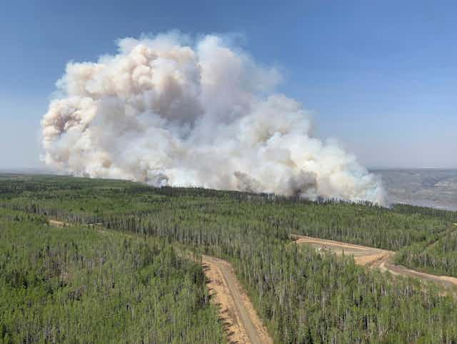
What’s more, while Canada does track emissions from natural disturbances (such as in a forest fire) occurring in managed areas, it does not actually report these disturbances to the UN as part of its LULUCF emissions, based on the claim that these are not anthropogenic.
Read more: Québec's hardwood trees could move north. Here's how that could affect the boreal forest landscape
While there is a logic to separating these out, there is a substantial difference to Canada’s total LULUCF emissions, depending on whether or not they are included. For instance, if natural disturbances are included in the tally, Canada’s managed land is typically a net source of carbon, while if they are not included, Canada’s managed land is typically a net carbon sink.
The underlying problem, however, is the lack of clear and transparent information about GHG emissions and removals in Canada’s unmanaged lands.
Estimates vary widely
Earlier this summer, during Canada’s unprecedented wildfire season, I asked the Ministry of Energy and Natural Resources of Canada (NRCAN) for historical information about the net Carbon flux in unmanaged lands. I was surprised to learn that NRCAN does not yet have this data.
What NRCAN does have is a very robust carbon budget modelling tool, and thanks to this, some preliminary (unverified) estimates of wildfire emissions in unmanaged forests.
Wildfire emissions estimates for unmanaged forests are indeed a step in the right direction (as wildfires account for the bulk of emissions from natural disturbances), but there still remains a majority of unmanaged land which is not forested — including, for instance, vast peatlands which are also subject to wildfires.
No GHG emissions of any type occurring in unmanaged lands are currently being tracked or reported within the National GHG Inventory process.

There have been various efforts to quantify these emissions, yet estimates vary considerably, with some data sets limited to forest lands, and others looking at the full national territory.
One recent estimate used 16 different “Dynamic Global Vegetation Models,” and found that over the 20-year period from 2000-2020 unmanaged forests sequestered on average about 189 Megaton CO2 per year.
However, the Global Carbon Project’s estimates of “atmospheric inversions” suggests there may be orders of magnitude more carbon removal in Canada’s unmanaged land.
The size of the discrepancy between these estimates is puzzling. While one obvious explanation comes down to the former model using intact forests as a proxy for unmanaged land, and the latter model including all of Canada’s unmanaged land area, scientists believe there may be more to this discrepancy.
A need for further research and better reporting
It is unfortunate that Canada has no publicly stated estimate of the country’s total carbon flux. This is important information to help track whether Canada’s landmass is sequestering enough CO2 to offset natural disturbances, or whether the latter are outweighing the former.
Read more: Carbon removal is needed to achieve net zero but has its own climate risks
It is essential that the Government of Canada enhance its current efforts in land-based carbon flux analysis, and that such data and analysis is reported to the public in a more clear and transparent way.