


Indonesian peatland researchers recently gathered in Bogor, Indonesia, to examine the effectiveness of the latest government regulation on peatlands. We found some shortcomings, one being that the regulation isn’t well supported by scientific evidence.
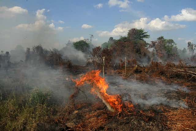
The Indonesian government declared that the area of peatlands burnt in 2017 declined significantly compared to previous years. After a disastrous fire two years ago, the Ministry of Environment and Forestry urged plantations to block canals and to build water retention basins and wells in peatlands.
Additionally, the government attempted to restore degraded peatlands by issuing Government Regulation (PP) No. 57/2016, which amended a 2014 regulation on the conservation and management of peat ecosystems.
One of the articles in the 2016 regulation states that a managed peat ecosystem is considered to be degraded if its water table is deeper than 40 centimetres from the surface of the peatland at a managed location. This regulation was meant to keep the peat moist to protect it from fire during the dry season. This also means that the water table in managed peatlands should be maintained at 40cm all year round.
This 40cm criterion was arbitrarily chosen. The regulation was set without involving or consulting academics and is not supported by adequate research and strong scientific evidence.
The implementation of this regulation should also consider the socio-economic balance between the communities and the environment surrounding peatlands.
Responding to this new regulation, academics and peatland practitioners organised a focus group discussion in Bogor on December 14, 2017, to discuss the best way to manage peat responsibly.
Peatlands are one of the largest carbon sinks in the Earth’s land ecosystem. And Indonesia has one of the largest peatlands in the tropics, with a recent estimate of 13.2 million hectares. Before the 1990s, peatlands were considered marginal lands and exploited without environmental concerns.
In 1995, the late President Soeharto directed the Mega Rice Project, which developed 1 million hectares of peatlands in Central Kalimantan for rice cultivation. The project failed. Rice did not grow and the heavily drained peats were degraded, fuelling fires during extended dry seasons.
Scientific gap
With increasing awareness of climate change issues – especially greenhouse gas emissions from agricultural sectors and land and forest fires – peat management has become a controversial issue in Indonesia.
Peat has two main functions: environmental services (water storage, carbon storage and biodiversity preservation) and agricultural production that supports the livelihood of farmers.
Science and research may be able to drive responsible management of our peatlands.
While there has been much research on peatlands in Indonesia, most international research focused heavily on deforestation, greenhouse gas emissions and peat fires. We need research on effective peatland management that addresses the environmental issues and regulations.
Balanced research should also focus on good peat management practices that minimise its environmental impacts, and on effective water management that reduces the risk of fire.
From the discussion in Bogor, we identified scientific gaps in peat management:
1. Peatland mapping
Peatlands in Indonesia have been mapped at a rough scale of 1:250,000, indicating an area of about 13.2 million hectares. This map cannot be used for management and the implementation of PP 57.
For operational purposes, a scale of 1:50,000 or finer is needed. This fine-scale map needs to be generated using an accurate, cost-effective and rapid method.
In Indonesia, many were convinced that Lidar, aerial laser surveying that is used commercially, was the best method for mapping the extent and thickness of peat.
However, lidar operation throughout the country is costly. Furthermore, Lidar only measures the surface elevation of the ground and cannot detect directly the extent and thickness of peats.
Research from the University of Sydney and IPB has developed an Open Digital Mapping methodology, which combines field measurements and freely available satellite images. Peat extent and thickness can be mapped using machine-learning algorithms. This methodology, recently published in an international journal, is cost-effective as it uses open data in an open-source computing environment.
This method has been successfully evaluated and potentially can be up-scaled to map peatlands for the whole of Indonesia.
2. Leading commodities and land degradation
There have been many studies on strategic commodities in peatlands, especially food and cash crops, specifically oil palm. With the new regulation restricting oil palm plantation development, integrated cross-disciplinary studies need to be developed to seek new commodities that can support small-scale farmers. For example, paludiculture (farming in swamps) with market access needs to be developed.
The environmental impacts of land use change have to be assessed holistically. Agricultural land use in peatlands is often thought to be linked with the draining of peats, which led to peat degradation and vulnerability to fire. As a result, the use of peatlands is associated with increasing carbon emissions into the atmosphere.
Peatland degradation is a long process and is not entirely caused by the current land use. Land degradation has happened at least since the transmigration program during the Dutch colonial period and continued since the 1970s with the expansion of forest concession areas.
3. Greenhouse gas emissions and groundwater level
Land use on peatlands is often blamed for increased greenhouse gas emissions in the agricultural sectors. No doubt agricultural activities contribute to oxidation of organic matter. But the CO2 emission rates need to be fully examined, especially as a result of:
Peat subsidence, which is often interpreted as peat loss contributing to CO2 emissions. The subsidence process depends on the peat compaction and water level. Subsidence is not linear with time. In other words, subsidence occurred rapidly at the beginning of land conversion and its rate will decrease with time. A study in Central Kalimantan demonstrated that compaction is the main cause of the peat dome collapse.
The net greenhouse gas emission is a balance between sequestration (storage) and decomposition (breakdown) of organic matter. Emission rates fluctuate from morning to day and night, and from day to day. Most studies only measure the emission rates at a given time once a month. To account for all these variations, we need a fully integrated system that can monitor these fluxes over a long time.
The groundwater level set by Regulation No. 57/2016 is thought to lack a strong scientific evidence base. Groundwater level fluctuates seasonally with rainfall and drainage. It doesn’t necessarily reflect the peat’s moisture condition. In addition, the impact of a relatively high water table on plant growth needs to be further established.
The water content of the surface peat may be more indicative of the moisture status of peat. There is a critical water content at which peat becomes hydrophobic (difficult to rewet), and this point needs to be well researched and established.
Most studies only consider climate-driven prolonged drought as the driver for wildfires in the humid tropics. Our study shows that a simple Drought Index – which can be calculated from rainfall data, groundwater height level and groundwater condition – can serve as a better indicator of forest fire risk. Another study shows the importance of hydrology in predicting wildfires in Kalimantan, which can be used as a tool to improve planning and strategies to adapt to climate change.
The bottom-up approach
The current peat restoration process is a top-down approach by issuing new regulations. PP 57 is difficult to implement and has had negative reactions from the agriculture community. For a process to be fully adopted and well received by landholders and academics, it needs to be bottom-up and supported by well-grounded research.
The ideal approach includes:
Water management that optimises the water supply to maintain peat’s moisture condition and support plant growth, particularly in the dry season.
Maintaining groundwater levels not deeper than 80cm, measured from the peat surface. Peat should be always maintained in a moist condition so it wets up easily. Hydrology models to monitor drought and susceptibility can help predict the risk of fire.
Managing peatland responsibly with best management practices that support plant growth and livelihoods without causing land degradation and fires. These practices involve good water management, monitoring and maintaining moist peat condition, proper fertilisation, establishing cover crops, using adapted plant varieties, etc.
From all that, we need a more comprehensive research program that includes technology adaptation, community development and co-operation between communities, farmers, business owners and the government. The outcomes can then be used to formulate a responsible peatland development program in Indonesia.