
This week’s 5.3 magnitude earthquake that struck near Moe in Victoria’s brown-coal mining region of the La Trobe Valley brings to mind the 5.6 magnitude quake of 1989 in another coal-mining heartland: NSW’s Hunter Valley.
Mining cannot be blamed for the Moe quake in the La Trobe Valley’s coalfields. However, it can be argued that mining played a large part in the destruction wrought in 1989 upon Newcastle, with its proximity to underground black-coal mining.
Newcastle’s first coalfield opened in 1801. While the region has prospered economically since the 1950s as a result of exporting black coal to China and Japan, it has also experienced an undesirable consequence of booming mining operations in the form of frequent damaging seismic activity which includes earthquakes in 1841, 1868, 1925, 1989 and 1994.
Due to its unusually high seismic activity, this mining region is referred to as the “Newcastle Triangle Seismic Hazard Zone.” Earthquakes with a magnitude of greater than 5 on the Richter scale occur, on average, every 40 years in this locale. Other areas of New South Wales — such as the Tasman Sea Margin Zone, for example — experience such seismic events, on average, every 170 years.
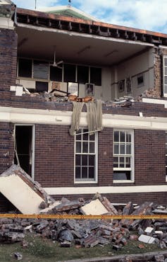
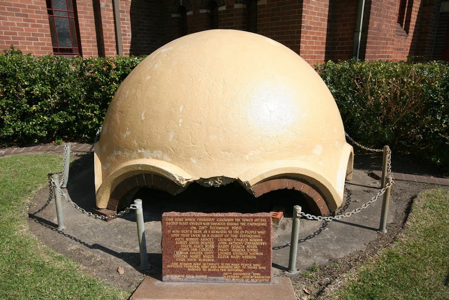
The 1989 Newcastle earthquake has been attributed to deep coal mining in the region. In addition to leaving 13 people dead, more than 160 in hospital, and thousands of buildings damaged, the magnitude 5.6 earthquake resulted in economic losses equivalent to almost A$5 billion, adjusted for inflation. The monetary losses totalled 3.4% of Australia’s Gross Domestic Income (GDI) or 80% of the nation’s GDI per capita growth, illustrating how destructive mining-induced earthquakes can be when urbanisation practices and mining activities are not pursued in a risk-balanced manner.
Could it be a coincidence?
Is the elevated seismic hazard in Newcastle really a result of black coal mining? Or is it a pure coincidence, with the region simply being tectonically active? Research data, analysed over decades, suggest that mining has caused seismic activity in and around Newcastle.
The horizontal deformation (or sideward drift) rates of the local tectonic plate in the Lake Macquarie region, where Newcastle is situated, are lower than what current GPS instruments are able to record accurately (GPS instruments are used to measure horizontal velocities of the moving plates of the earth’s crust). The velocities of the tectonic plates in southern Australia are extremely small. Therefore we talk about this being a Stable Continental Region. The only existing deformation is vertical movement down. Such deformation, called subsidence, is the result of the compaction of old mine shafts deep underground.
Subsidence is an effect that occurs above a deep mine. Another effect occurs below a deep mine, due to the redistribution of the existing tectonic stress field disturbed by the excavation process. High stresses exist inside tectonic plates and they are sensitive to any perturbations. The perturbation, or disturbance, of the stress field reaches beneath the excavations, mainly due to the removal of coal as well as the water that is extracted in order to keep the deep shafts dry.
This mass removal causes an “unload” of the entire continental crust. In the case of mining, an unload is the reduction of weight in a certain area, e.g., black coal and water in a colliery. If it has enough time, the tectonic plate reacts to this unload by forming a small deformation. If it does not have enough time because the rate of mass removal is too high, a fault zone can be reactivated or newly created and an abrupt reaction is induced - an earthquake is produced.
For a seismic event to take place, the stress perturbations need to be above the daily stress changes caused by the sun and the moon, plus the tectonic stress field in the crust and the pre-existing fault zone need to be oblique (at an angle that is neither a right angle nor a multiple of a right angle). Newcastle has the smallest stress vertical and the largest horizontal, and there is an oblique fault. This combination brings a fault closer to failure because the vertical component gets even smaller due to the unload. This reduction causes a reaction (e.g., relaxation) of the rock mass beneath the colliery. If a fault is right near this colliery it can set off earthquakes as part of the “relaxation” process.
If we had the smallest component horizontal and the largest vertical, it would reduce the likelihood of inducing a seismic event. This happened in Pakistan in 1974, when the impoundment of the Tarbela water reservoir locked a seismically active part of the crust at a depth of up to 70 km.
A global perspective
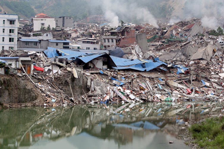
The 1989 Newcastle earthquake is not the only seismic event associated with geoengineering (such as mining, water reservoir impounding, fluid extraction of hydrocarbons or injection of liquid carbon dioxide, deep geothermal power generation, and coastal management). Other notable examples include the 2008 magnitude 7.9 earthquake in China, which occurred 2.5 years after the impoundment of the Zipingpu water reservoir, as well as the 2006 magnitude 3.8 earthquake in Basel, Switzerland, which was caused by deep geothermal power generation and resulted in millions of dollars in damage.
A new study, soon to be published in a special issue, Triggered and Induced Seismicity: Probabilities and Discrimination, of the Journal of Seismology, shows that there is a statistically significant relationship between man-made mass shifts in the Earth’s crust and earthquakes observed in close vicinity (fewer than 50 kilometres) of the geoengineering activities. Most of the earthquakes examined in the study were induced or triggered several years after the geoengineering activities had started. In concluding this special issue of the Journal, recommendations are provided for identifying human-made earthquakes.
Locations of geoengineering operations should be monitored and the seismic events should be analyzed based on the following model types a) physics-based, b) statistical, c) source mechanisms. Such models can discriminate between human-caused and natural seismic activity. At the same time hazard mapping in space and time is crucial to provide information to authorities urban planners. In the case of Newcastle, mining was, is, and will be a part of this region. The associated hazards need to be addressed and risk-mitigation measures need to be implemented, including reinforcement of buildings or changes in urban planning.
The risks associated with human-made earthquakes need to be addressed when large-scale geoengineering projects are planned. Ensuring sustainable geoengineering practices is especially important in the regions of high population densities. This is, in particular, important for deep geothermal power generation or carbon sequestration as hot spots for earthquakes crafted by human action.
Comments welcome below.