

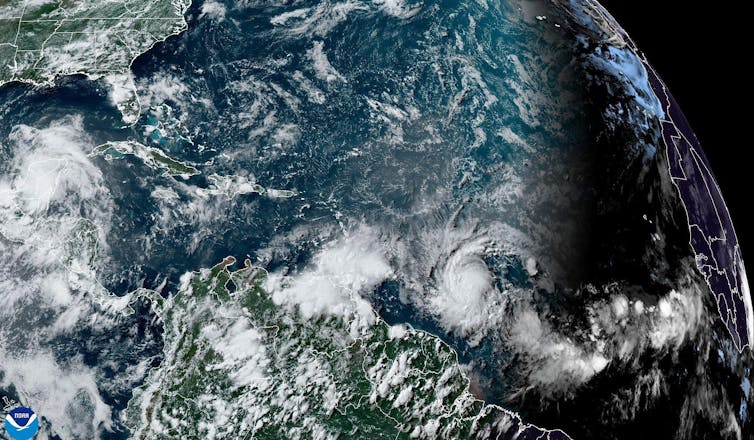
When Hurricane Beryl hit the Grenadine Islands on July 1, its 150-mph winds and awesome storm surge made it the earliest category 5 storm (the most destructive grade on the Saffir-Simpson hurricane wind scale) the tropical Atlantic has seen.
An active hurricane season in 2024 was forecast well in advance. However, the speed at which Beryl intensified, jumping from tropical-storm strength with winds averaging 70mph to major-hurricane status with 130mph winds in just 24 hours, astounded scientists.
“Beryl is a storm more typical of the heart of hurricane season than of June, and its rapid intensification and strength have likely been driven by unusually warm waters,” says Brian Tang, an associate professor of atmospheric science at the University at Albany, State University of New York.
As the world heats faster due to record fossil fuel emissions, research suggests that there are more unpleasant surprises to come.

This roundup of The Conversation’s climate coverage comes from our weekly climate action newsletter. Every Wednesday, The Conversation’s environment editor writes Imagine, a short email that goes a little deeper into just one climate issue. Join the 30,000+ readers who’ve subscribed.
In a narrow band of the mid-Atlantic Ocean where most hurricanes form, sea surface temperatures are anomalously high. In fact, the ocean’s heat content – a measure of how much energy is contained in the surface water that hurricanes draw strength from – was close to its average for September on July 1.
Water accumulates heat slowly, so it is alarming to see ocean heat near its usual peak at the start of summer. If the tropical Atlantic is already producing such storms, what might the rest of the hurricane season hold?
A bumper season
“If the National Hurricane Center’s early forecast, released May 23, is right, the North Atlantic could see 17 to 25 named storms, eight to 13 hurricanes, and four to seven major hurricanes by the end of November,” says Jhordanne Jones, a postdoctoral research fellow who studies how climate change affects the scientific effort to predict hurricanes at Purdue University.
“That’s the highest number of named storms in any preseason forecast.”
Seawater hotter than 26°C (79°F) is the lifeblood of hurricanes. Warm, moist air is another prerequisite. But that’s not all these monsters need to reach the limits of their savagery: consistent winds in the upper and lower atmosphere are also necessary to keep cyclonic storms spinning.
A shift from El Niño to La Niña – two opposite phases in a long-term temperature pattern in the Pacific – is expected later this summer. This could tamp down trade winds that might otherwise tear a hurricane’s vortex apart. Jones says:
“La Niña may indicate an early start to the season as well as a longer season, as La Niña – along with a warm Atlantic – maintains a hurricane-friendly environment earlier and longer within the year.”
You might expect global heating to bring more hurricanes. But that’s not what research has found so far, according to Ben Clarke (University of Oxford) and Friederike Otto (Imperial College London), two scientists who try to attribute the role of climate change in extreme weather events.
“Warm, moist air and high ocean temperatures are in ample supply in a rapidly warming world. Yet there is no evidence that hurricanes are happening more often, nor do scientists expect this to change with further climate change,” they say.
Instead, hurricanes that do occur are more likely to be major storms like Beryl. Conditions for breeding hurricanes will be found further north and south of the equator too, since the ocean is heating rapidly everywhere. And Atlantic hurricanes may form outside of the season (June 1 to November 30) that people have come to expect them in.
Read more: Hurricane Ian: how climate change is making North Atlantic tropical storms worse
“There is also evidence that they are moving more slowly, and are increasingly likely to completely stall near the coast, leading to more flooding as more rain is dumped over one place. This was one reason why Hurricane Harvey, which struck Texas and Louisiana in 2017, was so destructive,” Clarke and Otto say.
The trio of deadly hurricanes (Harvey, Irma and Maria) that hammered the Atlantic in quick succession that summer gave people little respite. These “storm clusters”, as climate adaptation researcher Anitha Karthik (Edinburgh Napier University) calls them, are a growing weather trend that is making hurricane-prone areas increasingly inhospitable.
Read more: Big storm clusters are on the increase – what this means for hurricane hotspots
Climate colonialism
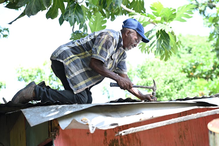
“When Hurricane Maria struck the eastern Caribbean island of Dominica in 2017, it caused the kind of devastation which is unthinkable to larger countries,” says Emily Wilkinson, an expert in climate resilience at the University of the West Indies.
“The category 5 hurricane damaged 98% of building roofs and caused US$1.2 billion (£950 million) in damage. Dominica effectively lost 226% of its GDP overnight.”
Vowing to become the first climate-resilient nation, Dominica set about rebuilding homes, bridges and other infrastructure. Conserving the forests and reefs that buffer rain, wind and waves was a priority, Wilkinson says. But in trying to build a sustainable future from the wreckage of Maria, Dominica had to contend with its past as a European colony – a fate shared by many small-island states in the Caribbean and elsewhere.
Read more: How a small Caribbean island is trying to become hurricane-proof
“Across most Caribbean islands, hazard exposure is about the same, but research shows that poverty and social inequality drastically magnify the severity of disasters,” say Levi Gahman and Gabrielle Thongs, lecturers in geography, also at the University of the West Indies.
Dominica had a plantation economy imposed on it by the British that squandered the island’s productive potential and funnelled its wealth overseas, Wilkinson says.
“Yet Dominica also has the Caribbean’s largest remaining indigenous community, and the Kalinago people have farming practices that combine crop diversification with planting methods that help stabilise slopes,” she adds.
Read more: In the Caribbean, colonialism and inequality mean hurricanes hit harder
Climate-vulnerable states can draw from advantages such as these to navigate an uncertain future. But the experiences of Caribbean islands show how a supposedly historical process like colonialism still claims lives in the present.
Mounting storms will add greater urgency to demands for “climate reparations” to the formerly colonised world from rich countries that have contributed most to the climate problem.