

Storm Ciarán made landfall in south-west England and northern France overnight on November 1, with heavy rain and winds blowing up to 180 kilometers per hour (108 mph).
The UK Met Office names storms each winter season, which starts in early September, and has decided to name them after people working “to keep people safe in times of severe weather” for the duration of the 2023/24 winter storm season. In this case, Ciarán is a tribute to Ciarán Fearon, a Northern Irish civil servant working in flood monitoring.
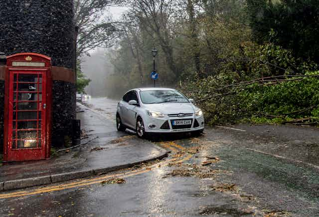
Storm Ciarán prompted amber and yellow weather warnings from the UK Met office and red weather warnings from Metéo France. High winds have disrupted travel, blocked roads and drains with debris and damaged overhead lines, leaving over a million people without electricity in both countries.
Given how early Ciarán arrived in the winter storm season, trees are still in leaf and anchored in soil that is waterlogged from recent wet weather, putting many trees at risk of being uprooted.
Flood warnings were issued across the south of the UK and some parts of the east coast as heavy rain has met with sodden ground and already swollen rivers.
Storm Ciarán is an extra-tropical cyclone (in other words, a rotating storm which forms outside the tropics) and unusual among North Atlantic storms, which rarely produce both heavy rain and high winds over large areas.
Low pressure in the eye of the cyclone deepened rapidly as it moved over the UK, dropping by more than 24 millibars in 24 hours to a near-record low of 953 millibars. This is what meteorologists call a bomb cyclone.
Forming a sting jet
Only two events with similarly low pressure have been recorded this far south in the UK. Satellite images taken the day before the storm hit suggested a sting jet (a stream of air that can form within a storm and produce extremely intense winds over a very small area) was forming that could strike the north of France.
Ciarán is the UK’s third named storm in a winter storm season that is shaping up to be exceptionally turbulent. The first named storm was in September (Agnes), which is very early. And the UK also had a named storm in August 2023 (Antoni), which is highly unusual.
Large parts of the UK saw twice the average amount of rainfall in October too, largely due to Storm Babet that flooded parts of the north of England and Scotland and left around 100,000 people without electricity. In the lead up to Storm Ciarán, severe flood damage was reported in Newry in Northern Ireland and Wexford in Ireland.
Why autumn 2023 has been so stormy
The succession of storms since August 2023 has been driven by an unusually strong jet stream that has shifted further south than is typical for this time of year.
The jet stream is a band of very strong wind high in the atmosphere that can extend across the Atlantic and bring storms to the UK. A stronger jet stream can make storms more powerful, and a more southerly position means that storms are warmer and carry more moisture and energy, making rapid intensification more likely.
Similar conditions were present for Storm Babet, though Babet became cut off from the jet stream instead, causing it to stall over the UK. Such slow-moving storms can produce more persistent rainfall over one region and cause flooding and are predicted to become more common in a warmer climate.
The strength and position of the jet stream is related to the temperature difference between cold polar air and warmer sub-tropical air. The jet stream is stronger when this south-to-north temperature difference is greater.
The boundary between polar and tropical air masses is further south than normal for this time of year due to anomalously warm sea surface temperatures in the western Atlantic, coupled with anomalously cold conditions in the southeastern US. This has fuelled successive storms over northern Europe.
The unusual strength and position of the jet stream is probably a result of the positive phase of the El Niño southern oscillation, a natural cycle in Earth’s climate which brings higher sea surface temperatures to the western Pacific. El Niño also contributed to the UK’s extremely wet and windy 2013/14 winter season and often causes extremely low temperatures over North America and windy and wet conditions in Europe.
More wet and windy conditions ahead?
Winter storms that hit northern Europe will unleash heavier rainfall in future due to climate change, as warmer air holds more moisture. Scientists are less certain about how wind will differ in future storms, as the relevant processes, such as those causing changes in the jet stream, are more complicated.
However, research suggests that storms which combine high winds and extreme rainfall, like Ciarán, will happen more often over northern Europe in future. This will compound the risks of climate change as the effects of flooding and wind damage accumulate.
Recent storms show that society has not adapted to worsening climate conditions. Reducing greenhouse gas emissions will mitigate risks from extreme weather. But national emission pledges commit the world to more warming and with it, more intense flooding and storm damage.
Alongside drastically cutting emissions, countries must build more resilient infrastructure to adapt to a more turbulent climate. This will be costly, but far less costly than doing nothing.

Don’t have time to read about climate change as much as you’d like?
Get a weekly roundup in your inbox instead. Every Wednesday, The Conversation’s environment editor writes Imagine, a short email that goes a little deeper into just one climate issue. Join the 20,000+ readers who’ve subscribed so far.