
At risk of being accused of being some sort of sinister harbinger of earthquakes, I must confess I happened to be en route to Christchurch, in New Zealand, when the latest magnitude 5.7 earthquake occurred on Sunday beneath the Pacific ocean.
I’d just finished a week hunting active faults in deep native bush in the South Island with my friend and colleague Rob Langridge. We were driving along Highway 73 through the centre of the island, searching the airwaves for the NZ-Australia cricket score.
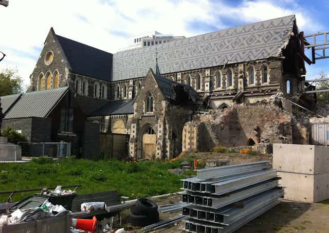
Alas, when I heard of a strong damaging earthquake in Christchurch on the radio, the old feelings of anxiety and sadness came surging back. I had a major scientific role as an Associate Professor at the University of Canterbury in the 2010-2011 earthquakes and lived in Christchurch for eight years. We were badly affected by the earthquakes and lost our house in eastern Christchurch.
I was surprised at how persistently these feelings must reside simmering in my psyche, even from my new position at Melbourne University across the ditch. It is obviously important to consider what this recent earthquake means for Christchurch’s seismic future.
The magnitude
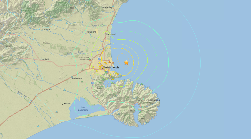
First, the details. The magnitude 5.7 earthquake was centred approximately eight kilometres offshore on a moderately dipping reverse fault. Earthquakes of this size typically result from fault ruptures about five to seven kilometres long, with up to about a meter of seismic slip.
The type of faulting and resultant shaking pattern was similar in some ways to the magnitude 5.8 and 5.9 earthquakes to hit Christchurch on December 23, 2011. Some of the aftershocks from the most recent event are also strike-slip where rocks on opposing sides of the fault slide laterally past one another, like the magnitude 7.1 Darfield earthquake that occurred about 40 km west of Christchurch in 2010.
An instrumental measure of earthquake shaking intensity, termed “peak ground acceleration” – now known well by many residents around Christchurch – reached up to 30-40% of gravity.
In vulnerable sediments, the threshold for triggering liquefaction is about 10-20% of gravity. As a consequence, liquefaction occurred in the places we expected it to, with the severity we would have expected for an earthquake of this size in this location.
Liquefaction didn’t occur in many places in central and southern Christchurch, where it had during the February earthquake, because the shaking wasn’t strong enough.
In case you were wondering, no liquefaction occurred in the land formerly occupied by my house, now owned by the Crown. I would have predicted no sand volcanoes would erupt given the measured ground accelerations and distance from the earthquake, but I couldn’t resist checking.
The shaking in this most recent earthquake was strong enough to cause loose rock to tumble from cliff faces around the coast.
Many of these areas had already been well designated by the the Canterbury Earthquake Recovery Authority (CERA) and Christchurch City Council as high hazard Red Zones, which are areas of widespread land and infrastructure damage where repair or remediation are considered to be prohibitively difficult.
This certainly provided some validation for the power of science and technology to assist with land use zoning decisions. The tumbling of rock off of coastal cliffs continues to remind us (particularly the kayakers, boaters and surfers) that keeping a 30 to 50 metre separation from steep bedrock cliffs when out in the ocean reduces the risk of being hit by falling rocks.
This applies even to cliffs where prior earthquakes didn’t cause rockfall, because the rock mass has been seismically weakened in most cases throughout the region, and continues to pose an ongoing hazard. Of course we can’t (and shouldn’t) Red Zone these marine environs, but we can keep them in our minds.
Is there a pattern?
The published annual statistical likelihood of Sunday’s earthquake prior to it occurring was 49%. And because this event has occurred, there is now a 63% chance another quake between magnitude 5 and 5.9 will occur in the region in the next year.
Even prior to Sunday’s earthquake, the annual rate of magnitude 4 earthquakes through this part of Canterbury in 2015 – a seemingly quiet year for earthquakes – was still more than ten times greater than the pre-Darfield annual rate.
We expect several magnitude 4 aftershocks over the coming weeks from Sunday’s earthquake, which will be most strongly felt along the eastern Canterbury coast. For each of these magnitude 4s, we would expect ten magnitude 3 earthquakes and a hundred magnitude 2s.
A research paper by Philip Barnes and his colleagues published just last week showed new maps of active faults they identified in Pegasus Bay, just north of Christchurch, including some in the approximate area of Sunday’s earthquake.
The recurrence interval of earthquakes on these faults may be 10,000 years or longer. However, the effect of stress redistributions in the crust resulting from prior earthquakes in this area, particularly the magnitude 5.8 and 5.9 earthquakes in December 2011 and magnitude 6 earthquake in June 2011, means that these structures are continuously being pushed and prodded closer to rupture.
While a few years may seem long on a human timescale, the occurrence of these strong Canterbury earthquakes years apart is equivalent to a blink of the eye over geological timescales. The coarse resolution in which we can study these faults using geology and geophysics prohibits us from knowing whether they have ruptured in short succession in the past (within years or decades), or whether their past ruptures were separated by centuries.
The point is: the Canterbury earthquake sequence has periods of relative quiescence and resurgence, is still ongoing, and is affecting crustal stress in an area where we know there are active faults, some of which Barnes and colleagues show in their recent paper are large enough to generate magnitude 7 or greater earthquakes.
Preparing for the future
So what next? And what can we do about it? While the Canterbury earthquake has generally migrated eastward through time since 2010, there are clearly still portions of smaller faults throughout the region that are capable of generating large earthquakes.
These include faults southwest of Christchurch and offshore faults to the northeast like the source of the most recent event. No scientist would dismiss the possibility that a larger magnitude earthquake could occur offshore, even though the statistical probabilities of a magnitude 7 of more occurring in the region remain below 1% over the next year.
I maintain that the 1992 Landers earthquakes (magnitude 7.3, 6.2 and 6.3 earthquakes) followed by the 1999 Hector Mine earthquake (magnitude 7.1) in eastern California provides us with a useful analogue for Canterbury.
The fault orientations and likely ocean floor displacements predicted from future Pegasus Bay earthquakes suggest low potential for a large, locally sourced tsunami. Nonetheless, a brush up on tsunami evacuation routes and awareness of local areas of high ground like parts of Bottle Lake, on the coast of Christchurch, and the sand dunes along New Brighton a little further to the south provide avenues for continued discussion with scientists and authorities for coastal dwellers.
Clearly, we cannot rule out any geological scenario with complete confidence. So we must continue the conversations and New Zealand must maintain its collective reputation as one of the world’s most scientifically literate general publics in the field of earthquakes. Kia kaha Christchurch.