

If you think the weather this month has been like Groundhog Day (albeit much hotter), you’d probably be right! Much like a stuck record, weather systems seem to have stalled over most of the country.
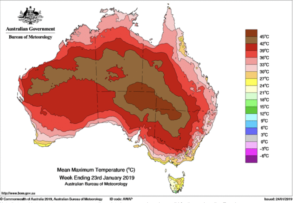
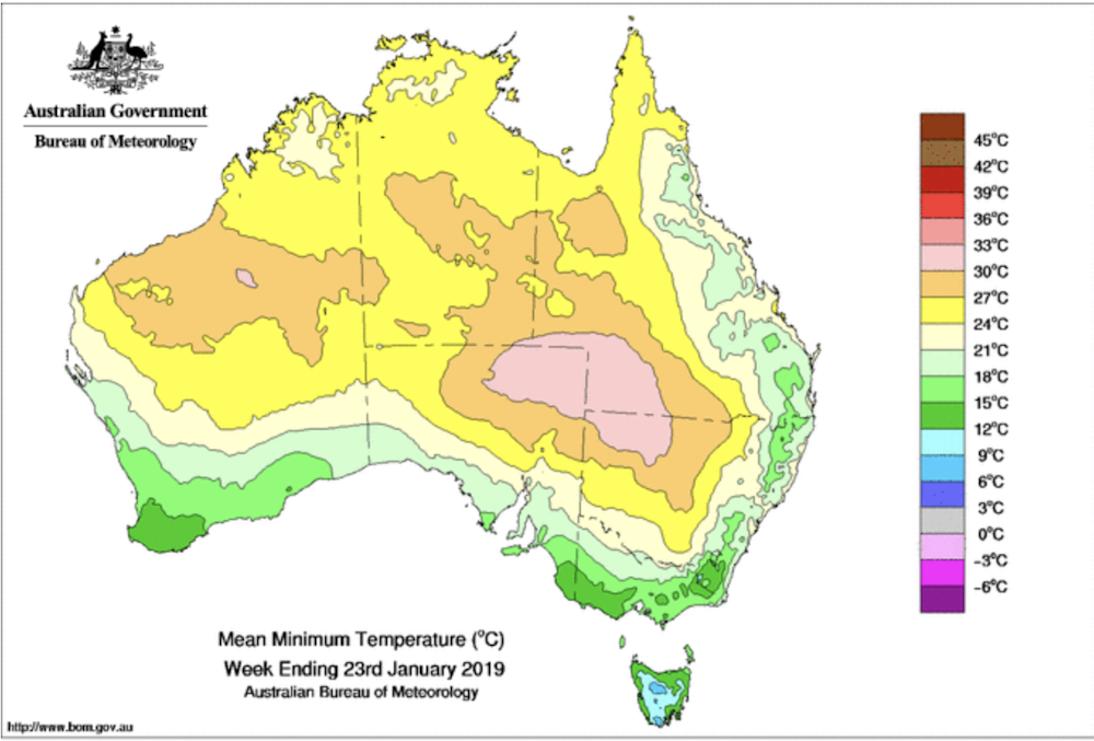
Brisbane residents are questioning the lack of rain, storms and heat. Darwin has just endured its second-latest monsoon onset on record after weeks of heat and humidity. Interior towns and cities have experienced significantly hot weather with a number of new maximum and minimum temperature records broken, along with records for consecutive days over 35°C.
Read more: Coastal seas around New Zealand are heading into a marine heatwave, again
Perth has largely escaped the heat so far this summer, while Sydney and Hobart have had a mixed bag. Coastal sea breezes have tempered conditions in the south and southeast of the continent. However, heatwaves are forecast for Melbourne and much of the southeast, with the arrival of strong, hot northerly winds. This will also bring extreme or severe fire weather conditions in many areas, including Tasmania. Adelaide, meanwhile, has sweltered through the hottest day on record for any Australian capital.
These weather patterns across the country are largely due to a stubborn blocking high-pressure system that has remained over the Tasman Sea since early January, affecting weather on both sides of the ditch. This type of strong high-pressure system typically forms further south than usual, and remains almost stationary for an extended period, thus blocking the west-to-east progression of weather systems across southern Australia.
Read more: Australia's 'deadliest natural hazard': what's your heatwave plan?
Sometimes, these blocking highs position themselves over the Great Australian Bight. They can occur at any time of year, and can stay in the Australian region from several days to several weeks.
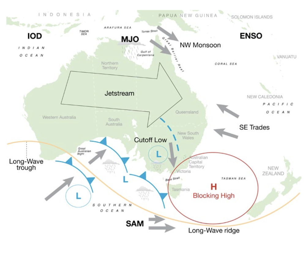
Winds rotate anticlockwise around high-pressure systems in the Southern Hemisphere. On the northern flank of the blocking high, southeast trade winds have been affecting northern New South Wales and eastern Queensland due to a persistent ridge of high pressure. These winds have been largely cool and dry, with only the far north of Queensland experiencing significant showers. The ridge has kept the inland trough further west over inland NSW and Queensland, preventing normal afternoon thunderstorm activity in the inland, and adding to the woes of the extended drought.
Cool, moist weather from the Southern Ocean is being displaced southeast by the blocking high, resulting in prolonged continental heatwaves and lack of rain. On the western flank of the blocking high, hot dry northerly winds from the arid centre are pushing through South Australia and Victoria, generating heatwave conditions.
Read more: Why we're hardwired to ignore safety advice during a heatwave
Across the ditch, cooler and drier southerly winds are affecting much of New Zealand. Only the southwest of the South Island is getting any significant rain due to persistent moist westerlies on the southern flank of the blocking high.
An unusually strong ridge of high pressure across Queensland, extending up to Cape York, has kept the monsoon trough north of the continent. This pattern is forecast to change as a deep tropical depression forms in the Gulf of Carpentaria over the coming days and moves south into northern Queensland. Unfortunately, the stubborn ridge of high pressure over central Queensland is likely to block the rain-bearing low from moving much further south over drought-stricken parts of inland Queensland and NSW.
Read more: Coping with heat waves: 5 essential reads
While parts of the country have sweltered, the far southwest of Australia has experienced cooler and wetter than average conditions this month. Cape Leeuwin, Australia’s most southwesterly point, set a 123-year daily rainfall record for January, recording a massive 57mm of rainfall.
In the short term, there is no indication that the blocking high will break down or move eastward. Forecasters on both sides of the Tasman expect the pattern to continue until February at least.
Read more: Are heatwaves 'worsening' and have 'hot days' doubled in Australia in the last 50 years?