

Forget pizza delivery, the latest use for drones may surprise you even more.
In the tropics, my colleagues and I have used drones to map a vital ecological indicator – the temperature at which lizards thrive. This innovative technique could revolutionise our understanding of reptile conservation in a changing climate.
We’ve all been out on a warm day and have looked to find some shade, or grabbed an extra layer of clothing on a cold day. But imagine that your daily life is dependent on keeping your body within the “perfect” temperature range. This is what life is like for cold-blooded species like lizards.
Cold-blooded animals are dependent on ideal temperatures for life. So, for their conservation, researchers need a way to analyse the quality of the heat conditions they live in. This is even more important given how people are modifying landscapes through activities such as deforestation and the ever-growing threat of climate change which means cold-blooded creatures have less shade.

Our study species is no stranger to such pressures. The Bay Islands anole, Anolis bicaorum, is a lizard found on the island of Utila, north of mainland Honduras in Central America.
The island is undergoing significant development resulting in the conversion of the lizard’s favoured forest habitat to urbanised areas. This lizard, a critically endangered species according to the International Union for Conservation of Nature, is only found on this small island and is under threat from this habitat loss.
A previous study of mine found that the thermal environment is a vital factor in determining the number of individuals of this species. So, it is important to measure this as the basis for successful conservation strategies.
Traditionally, measuring a lizard’s thermal environment has been a laborious and costly affair. It involves deploying 3D-printed lizard replicas which are equipped with special thermometers to log the nearby temperature of the forest.
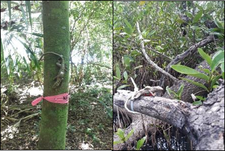
While these replicas provide valuable data points, their limited number due to expense – typically around 20 per study plot – restricts the scope of analysis. This scarcity of data makes it difficult to assess thermal suitability across entire landscapes, a crucial factor for conservation planning. This is where my team’s recent research using drones comes in.
If the forest canopy plays a crucial role in regulating a lizard’s body temperature, we wondered whether we could predict those temperatures by using equations based on canopy characteristics.
To test this, we first needed to collect canopy data. And we used drones to do that.
Drones have transformed data collection, allowing us to gather detailed canopy metrics across entire study areas. We used a drone to hover a few metres over each plot, capturing high-resolution images.
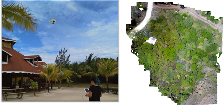
From these images, we extracted data on two important factors: the percentage of greenness (indicating canopy cover) and texture indices (representing variation in the canopy structure).
By combining this detailed drone-based canopy data (greenness and texture) with ground-based air temperature measurements, we aimed to predict the temperature an A. bicaorum lizard would reach on the island of Utila.
And we found that it works, for this particular lizard, and in this environment at least. By using the drone data and coupling it with air temperature and machine learning models, we can predict the temperature of A. bicaorum at solar noon, the sun’s highest point, across the entire survey plot.
This method allows us to create continuous, high-resolution maps of temperatures across entire landscapes. And this level of detail is far more relevant to the movement patterns of individual lizards compared to the limited data points collected with traditional methods.
Why this is important
A double threat looms for cold-blooded creatures worldwide: climate change and habitat loss. These factors are rapidly transforming the planet’s thermal environment, potentially squeezing the suitable habitat available for cold-blooded species. The consequences could be far-reaching, affecting the fitness and energy expenditure of countless animals.
Our drone-based approach allows us to map ecologically significant thermal data across vast landscapes, at resolutions relevant to individual animals and populations. This level of detail far surpasses the limitations of traditional ground-based methods.
The next step for our research is to test this method across different species and habitats. We also need to incorporate 3D data into our analysis, allowing us to map thermal variations throughout the day, not just at peak sunlight at solar noon. This will provide a more comprehensive picture of how different species use their thermal environment.
Our work opens a new window into understanding how human activities and climate change affect species like the A. bicaorum lizard, particularly those in forests where suitable thermal environments are crucial for their survival.