For Australia’s climate, 2016 was a year of two halves. The year started with one of the strongest El Niño events on record in place in the Pacific Ocean, and the opening months of 2016 were generally hot and dry, especially in northern and eastern Australia.
From May onwards there was a dramatic change in the pattern, with heavy rain and flooding a regular feature of the middle months of the year.
Overall temperatures were the fourth warmest on record in 2016, capping off Australia’s hottest decade. We track these events and more in the Bureau of Meteorology’s annual climate summary released today.
Dry to start
At the start of 2016, many parts of Australia were significantly affected by drought. Long-term drought had existed since 2012 through much of inland Queensland and adjacent northern areas of New South Wales, while shorter-term drought affected Tasmania, central and western Victoria, and parts of South Australia.
While some rain fell between January and April in these areas, it was generally not enough to have much impact on the rainfall deficiencies. Tasmania was hit especially hard, with low water storages restricting hydroelectric production, and long-lived and extensive bushfires in central and western parts of the state a feature of the summer period.
January to April, normally the wettest time of the year across Australia’s far north, was also much drier than normal with rainfall well below average in the Kimberley, the Northern Territory Top End, and on Cape York Peninsula.
It was the least active Australian tropical cyclone season since comprehensive satellite records began in 1970, with only three cyclones in the region, none of them severe, and only one of which made landfall.
The rains are here
Widespread heavy rains began in May – something well predicted by seasonal forecast models - as the El Niño ended and conditions in the Indian Ocean became very favourable for Australian rainfall, with unusually warm waters between Western Australia and Indonesia. Each month from May to September was wetter than average across most of the continent, with heavy rains extending into areas such as inland Queensland where the winter is normally the driest time of the year.
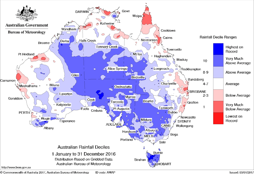
The wet conditions culminated in September, when nationally averaged rainfall was nearly three times the average. It was the wettest September on record for New South Wales and the Northern Territory, and in the top four wettest for every state except Western Australia and Tasmania.
May to September was the wettest on record over Australia, with some locations in inland New South Wales breaking previous records for the period by nearly 200 millimetres. Rainfall returned to more normal levels in eastern mainland Australia from October onwards, although Tasmania remained wet, and a tropical low brought widespread heavy rains extending from the Kimberley south through central Australia as far south as South Australia and Victoria in the year’s final days.
Despite flood damage in places and some rain-affected harvests, the wet conditions were generally positive for agriculture. They also led to large increases in water storage levels in many areas, especially in the Murray-Darling Basin and in Tasmania.
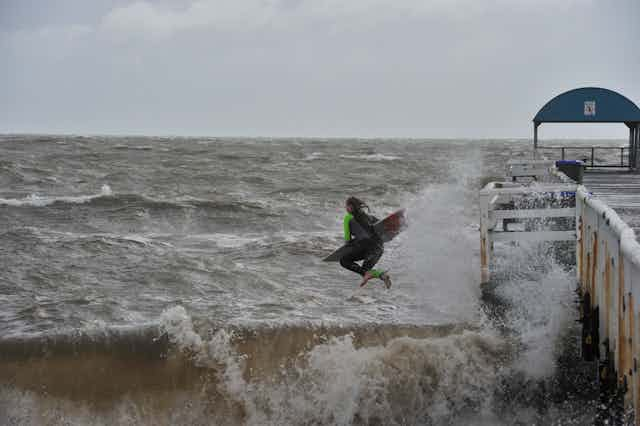
Flooding and storms were also a feature of this period. In early June, an East Coast Low affected almost the whole east coast from southern Queensland southwards.
Northern Tasmania saw some of its most severe flooding on record, and the Sydney region suffered significant coastal erosion with some property damage. The heavy September rains led to major flooding on several inland rivers, particularly the Lachlan River in central New South Wales, and went on to produce the highest flood since the early 1990s on the Murray River in South Australia as the waters moved downstream.
An intense low-pressure system in South Australia at the end of September caused major wind and flood damage there. In Tasmania, which had further flooding in November, the seven months from May to November were the wettest on record, after the seven months from October 2015 to April 2016 had been the driest on record.
Over Australia as a whole, it was the 17th wettest year on record with rainfall 17% above the long-term average. Tasmania had its second-wettest year on record, despite the dry start, and South Australia its fourth-wettest. Below-average rainfalls in 2016 were largely confined to parts of the northern tropics, coastal areas of southern Queensland and northern New South Wales, and some parts of coastal Western Australia. Heavy rains in the year’s final week were enough to lift Adelaide to its second-wettest year on record, while Uraidla, in the Adelaide Hills, had the largest annual rainfall total at any South Australian site since 1917.
The heat is on
It was the fourth-warmest year on record for Australia, with temperatures 0.87°C above average nationally, 0.33°C short of the record set in 2013.
The year got off to a very warm start; it was the warmest autumn on record for Australia, and the first half of the year was also the warmest on record, although there were no individual heatwaves on the scale of those experienced in 2013 or 2014.
The second half of the year was less warm. During the wet months in mid-year, heavy cloud cover led to cool days but warm nights, then a cool October resulted in spring temperatures almost exactly matching the long-term average. A warm start and cooler finish is typical of a post-El Niño year as rainfall typically changes from below to above average.
It was the warmest year on record in many parts of the northern tropics, along much of the east coast, and in parts of Tasmania. Darwin, Brisbane, Sydney and Hobart all had their warmest year on record. The warmth on land in these coastal areas was matched by warmth in the oceans.
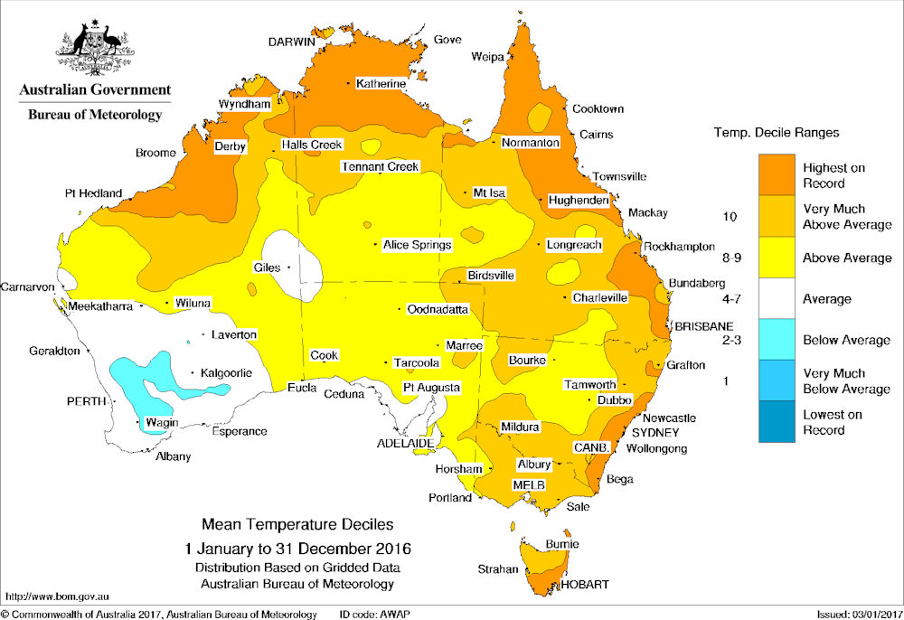
Sea surface temperatures in the Australian region were the warmest on record, with the first half of the year especially warm. The record warm waters contributed to extensive coral bleaching on the Great Barrier Reef, and also affected fisheries in Tasmania.
Temperatures were closer to average in other parts of the country, including inland areas of the eastern states, South Australia and most of Western Australia. In a few parts of southern Western Australia, which had its coldest winter since 1990, temperatures in 2016 were slightly below average (one of only a handful of land areas in the world where this was the case), and there was some frost damage to crops in what was otherwise a very productive year for Australia’s grain-growers.
2016 continues a sequence of years with Australian temperatures well above average. While 2016 did not set a record, the last four years all rank in Australia’s six warmest, and the last ten years have been Australia’s warmest on record. 2016 is also almost certain to be the hottest year on record globally.