
As an archaeologist working in the remote areas around Woomera and the Nullarbor Plain, my understanding of South Australia was first informed by rocks and soil. This was a landscape of fossils and trace fossils – the preserved impressions left by the passage of a living body through sediment – jostling for attention. On this land surface, SA presents an arc extending from the “death mask” fossils of early multicellular life to the human leap into the solar system. Sure, you might say, this could be said of other locations on Earth. But here it seems laid bare for any who can read the distinctive pattern of signs.
The silent shore
This was once a shoreline in a silent world. Throughout some terrifying ice ages, when glaciers reached almost to the equator, microscopic single-celled creatures held on to life in the freezing oceans. As the ice sheets retreated, warmer shores opened up on the Gondwana supercontinent, including what would later become the Flinders Ranges. Microbes swarmed together in mats to colonise the sandy sea floor. Wind and water were the only sounds, but there was nothing yet with ears to hear them.
The rhythm of the waves created undulations on the sea floor, to which the microbial mats cleaved. For millions of years the green ocean carpet flourished in the shallow waters. Around 635 million years ago, new forms of multicellular life appeared as additional tiers in this simple ecology. Creatures similar in appearance to fern fronds anchored themselves in the mats by a round root-like hank. Others took the form of segmented worms squashed into round pancakes.
Far from “nature red in tooth and claw”, this was nature basking in the sun, in no hurry to change. Storms were the most dramatic events to occur over millions of years. The surges of water these produced would drag the button holdfast of the fronds across the sandy ocean floor, leaving a crackled trace until the wave passed and left it swaying again. In one of these storms, a sudden influx of loose sediment was dragged over some fronds, knocking them flat and covering them with silt. There was too much weight to break free and these limbless, toothless creatures had no way to burrow out.
Gondwana drifted, split, folded and, around 540 million years ago, uplifted, raising the ocean floor to form the slopes of a mountain range.
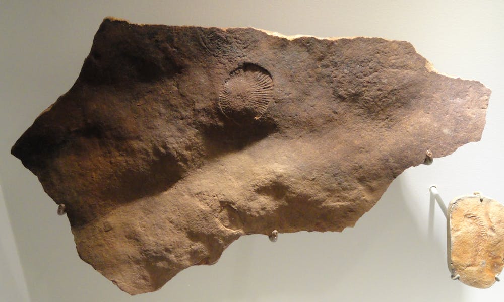
The fossilised fronds and pancake worms of the fauna from the Ediacaran geological period (635–542 million years ago) are now on display at the South Australian Museum. The ripples in the stone cast shadows that allow you to almost see the shimmering of the shallow water. The “elephant skin” texture – where the hank of a single fern frond was dragged in the storm surge – is visible in the stone, as is the wiggly path or trace fossil of a small worm that escaped burial.
In effect, South Australia is the trace fossil of an earlier continent, or an earlier planet – perhaps not even this one. The Ediacara fauna are vastly different to present life on Earth, and may provide an analogue for life elsewhere in the solar system.
The dust giants
In the Pleistocene era, starting from about 1.8 million years ago, the ice sheets advanced again. With so much water locked away in the ice, vast plains were exposed on the continental shelf. Plant communities died off and soil formation slowed as temperatures and rainfall decreased. No longer consolidated by vegetation, sediments were blown away in the cold winds. Aeolian is the word, like a harp with a dry rustling sound. The sand traversed huge distances and settled into waves of dunes reflecting the wind direction. The leaching of iron stained their quartz sands Martian-red.
Low saltbushes and bluebushes were studded across the dunes at the edge of the ranges, with occasional forests of large saltbush. Giant kangaroos, three metres high, were as tall as these forest canopies. They loped along the dunes with their smaller cousins, sometimes venturing to the open grasslands that stretched to the distant coast of Sahul.
The carnivore Thylacoleo carnifex roamed the plains, stalking Palorchestes azael and other herbivores. Waterholes were perilous places where the giant snake Wonambi naracoortensis coiled in wait. Taking shelter from the cold wind in a limestone cave, Aboriginal people might have looked out to see the huge shadows of a herd of diprotodons, the marsupial “rhinoceros”, or Genyornis, the two-metre-tall flightless bird. If these animals were reptiles, we would call them dinosaurs.
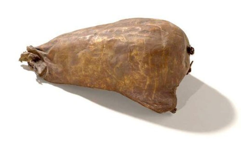
At the height of this cold, dry period – 30-19,000 years ago – a person might have seen the ocean only a few times across their lifespan. A nacreous abalone shell, excavated at Allen’s Cave on the Nullarbor Plain and dated to 18,000 years ago, speaks of a journey hundreds of kilometres overland to the shore. Specialist knowledge was needed to travel far from permanent or regular water sources: how to find water-bearing roots, rock wells, and Artesian springs. Perhaps more was needed too: kangaroo-skin water bags, the endurance to carry a coolamon of water for miles without spilling a drop. The desert sands and the porous limestones of the Nullarbor don’t hold water reservoirs, and the aridity turned the lakes to the west and north of the Flinders Ranges into salt.
Aboriginal people would have noted but passed over the sedimentary rocks that preserved the Ediacara fauna. Instead, they searched for chalcedony, chert, and silcrete. With an understanding of how these stones fracture, you can make a cutting edge sharper and more sterile than a metal surgical blade. Glassy veins of such stone, nacreous in their own way, occur throughout the Nullarbor plain.
Countless scholarly papers describe the climatic conditions and biological record of the Last Glacial Maximum. Between the lines of these papers we can catch a glimpse of how Aboriginal people may have experienced these landscapes. In the field, I look for traces of their life where the red dunes are exposed – a stone tool or the ashes of a hearth, perhaps. Mining companies, however, would mostly prefer these traces vanished.
A line in the sand
The ice melted again, and water inundated the great coastal plains. The megafauna were long gone, leaving the regular kangaroos, emus and wombats behind to compete with new migrants: sheep, cattle, camels and rabbits. The livestock, particularly cattle, thrived on saltbush.
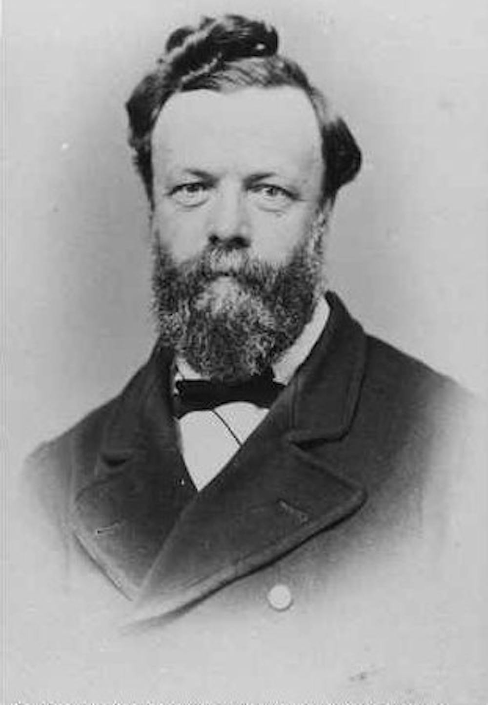
It was still arid out in the north and centre, though droughts lasted just a few years instead of thousands. The years 1863–66 were particularly severe. The Surveyor-General of SA, George Goyder, was sent out in 1865 to define the area where reliable rainfall divided agricultural from grazing land. In the absence of rainfall records, he observed geology and vegetation to create a line stretching over 3000 kilometres, from Pinaroo on the Victorian border to Ceduna in the far west. South of the line was dominated by mallee scrubs, and the north by saltbush and other chenopods.
A few years later, seasons had improved. The bold bought land above the Goyder Line for cropping. This line was not, however, just a mark on a map; as successive drought oscillations continued, farmers were forced back south, abandoning homesteads and even whole towns, the crumbling remains of which are still visible today.
In the process of settlement, trees were cut down for fence posts, telegraph poles and firewood. On the treeless Nullarbor Plain, soil was stabilised by delicate biological crusts formed from lichens and bacteria. The hard hoofs of the livestock cracked them like the toffee shell on a crème brûlée, and the dust blew again.
In 1945, the CSIRO scientist RW Jessup was sent to investigate soil erosion in arid areas of South Australia. He noted the degeneration caused by the combined effect of rabbits and stock. When rabbits reached plague proportions and began to run out of food, they ate the young shoots and ringbarked trees. Fast growing species could bounce back, but slower trees like mulga and myall suffered the most, especially in the absence of Aboriginal firing regimes to germinate seeds. Jessup noticed the Precambrian rocks but did not stop to look for fossils. He was more focused on the windblown sands: evidence of how pastoralism was recreating the arid conditions of the Pleistocene.
The same year saw the end of the Second World War. Far away in another hemisphere, a rocket capable of reaching outer space had been built and two atomic bombs deployed. These events would shape the world for decades to come, and leave their imprint in the outback of South Australia.
Uranium and rockets
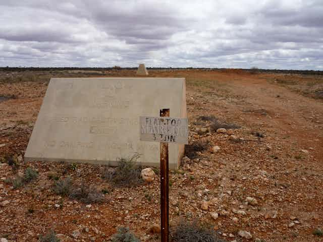
In 1946, there were many people roaming the South Australian deserts. One was geologist Reg Sprigg, searching for uranium to supply the growing demand for nuclear weapons. He started with the old Radium Hill mine in the east, and surveyed Mount Painter in the Flinders Ranges, before coming to the Ediacara Hills in the north of the ranges. On the gentle slopes, he was struck by ancient sandstone slabs, generally a poor type of stone for fossil preservation. But he’d seen fossils in this sort of rock before. The round impressions that he saw looked like flattened jellyfish and large segmented worms, but the rock was clearly Precambrian – an age when only single-celled animals were supposed to exist.
The discovery was initially received with scepticism. Some argued that the shapes were natural phenomena. Others disputed the dates. It wasn’t until the discovery of similar fossils in Namibia, Siberia and other locations, and the support of some University of Adelaide academics, that the Ediacara fauna were acknowledged to be genuine.
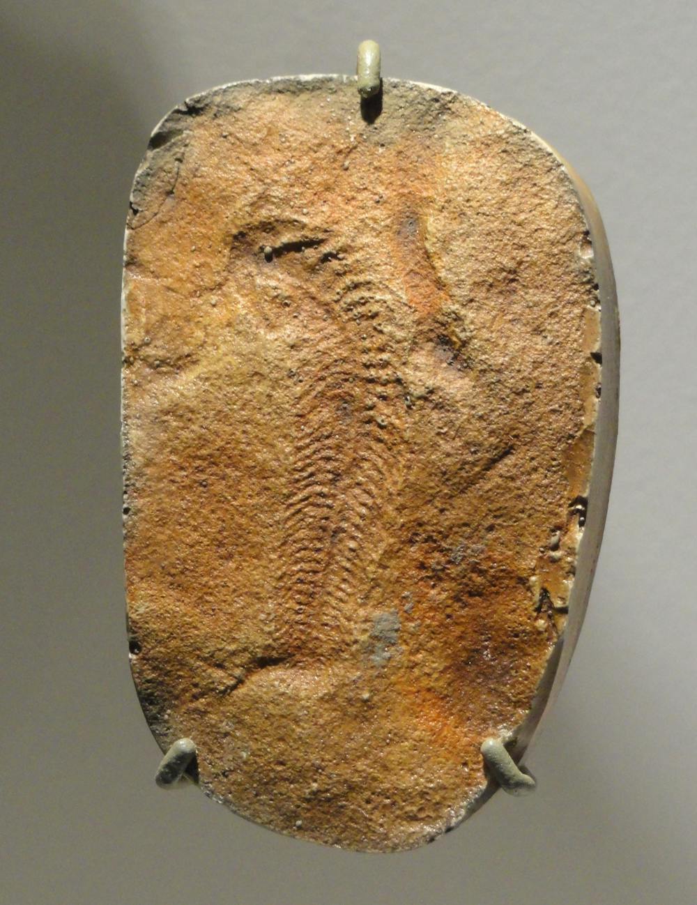
The creatures then received names. Dickinsonia was the flat pancake worm. The jellyfish turned out to be mostly the discoid holdfast of the frond-shaped Charnia. Reg Sprigg lent his name to the mysterious segmented Spriggina species – maybe a worm, maybe a frond, maybe something like the later trilobites.
While Reg Sprigg continued his search for uranium deposits, men from the Army’s Survey Corps were on the gibber plains around Mount Eba, mapping an area the size of England to enclose a rocket test range. The Anglo-Australian Joint Project was established to develop weapons for Britain, and Australia hoped, through this arrangement, to gain a greater defence capacity to fend off Asia. The German V-2 rocket, which had devastated London in the last months of the war, would form the basis of this new weapon system.
Senior British military personnel took a flight to see the proposed area for themselves. They flew over the Central Aborigines Reserve on the borders between South and Western Australia, the direction in which the future rockets would be launched. To their eyes, the red desert recalled another: the white sands around the Trinity site in New Mexico, USA, where the first atom bomb was exploded in 1944. The Australian author Ivan Southall described this view later in 1962:
Here it was, one of the greatest stretches of uninhabited wasteland on earth, created by God specifically for rockets.
Hidden in plain sight
Aboriginal people became a trace fossil in the land deemed empty – hidden in plain sight. Kokatha, Pitjantjatjara, Adnyamathanha and Barngarla people lived on missions around the state, and gathered in coastal towns that offered them the employment that the rocket range had promised but didn’t deliver.
At this time, white Australians thought Aboriginal occupation had been a few thousand years at most, and many believed Aboriginal people were dying out – the inevitable result of the “stone age” being superseded by the “space age”.
Ironically, it would take American chemist Willard Libby’s invention of radiocarbon dating in the 1940s – an idea that came to him when working on the atomic bomb for the Manhattan Project – to establish the much deeper antiquity of occupation. John Mulvaney’s 1962 excavation of Kenniff Cave in Queensland used radiocarbon to obtain a date of 19,000 years ago, during the Last Glacial Maximum.
In 1947, on the first reconnaissance for a place to build the township that would service the rocket range, surveyors found tens of thousands of stone tools at Phillip Ponds. Recognising that evidence of Aboriginal occupation also meant the presence of water, they selected this location for the Woomera Village, named after the wooden spear-thrower used by Aboriginal people in many parts of Australia. The street names in the new town were sourced from a vocabulary compiled by HM Cooper, published in 1948 as Australian Aboriginal Words and Their Meanings.
In the following decades, Australian scientists designed sounding rockets for upper atmosphere research and worked on British long-range ballistic missiles like the Blue Streak. They also collaborated with the US in establishing another new technology: tracking the satellites that were planned for launch in the International Geophysical Year of 1957–58. In 1957, the world’s first satellite, Sputnik 1, sent its distinctive beep into the ether. The Space Age had begun.
Radioactive
My trips to the Woomera Prohibited Area are sometimes to advise mining companies about heritage issues, and sometimes to do my own research on Australia’s space program. One day, I’m taken out to the derelict structures once used as launch pads for a unique hybrid rocket.
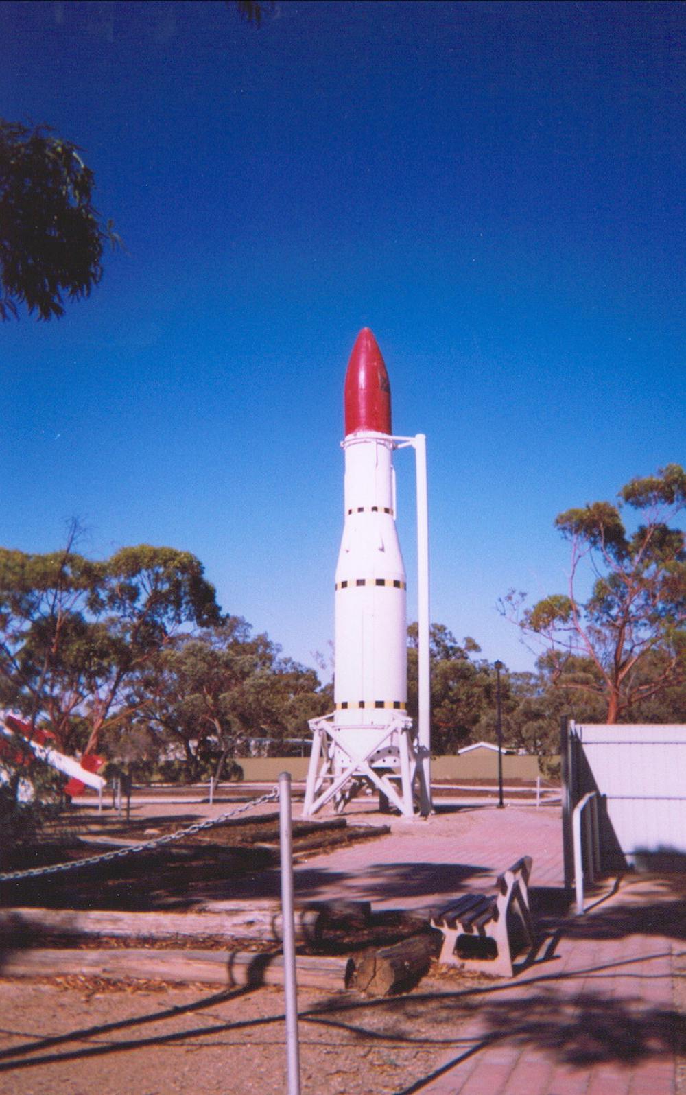
The satellite launcher Europa was a collaboration between six European nations and Australia in the early 1960s. The two launch pads stand on the edge of a blindingly white salt lake. Rock art sites can be found on outcrops and boulders around the lower edge of the steep shores. Against the wind, I imagine the tremendous roar of the rocket’s engines and think of Ivan Southall’s description of the landscape in his 1962 book, Woomera:
It’s almost like you are living in another world, just as though you had been shot off in a spaceship and let down on some strange planet where men had never been before.
Writing about Woomera and Maralinga, Southall constantly emphasises the silence of a landscape where, he avers, even Aboriginal people speak in undertones. This seems supremely ironic when you think of rocket engines roaring, or the more sinister blast of an atom bomb. From 1956 to 1963, Australia supported Britain in a series of nuclear tests at two locations outside Woomera’s perimeter, Maralinga and Emu Field. Southall visited Emu Field in 1962 where
sprayed with yellow paint, and silent in the sand, are abandoned trucks and jeeps and weapons once too hot to handle. There, near the bomb towers that vanished, the very surface of the desert has become as glass.
The vitrified sand is the same iron oxide-coated sediment of the Pleistocene aeolian dunes, now with a greenish tinge like a cheap wine bottle. Such nuclear glass is highly collectible, and is sometimes called trinitite after the glass from the Trinity site in New Mexico.
The resonances of these tests aren’t fading any time soon. Generations of Aboriginal people and white Australians still suffer the effects of exposure to radiation. The shadows of the radioactive fallout – the “black mist”, as many Aboriginal people call it – are almost inescapable when you travel west in this state.
At Woomera, I go to look at the grave monuments in the cemetery on the hill outside the town. There are multiple still births and infant deaths, often in the same family. People don’t like to talk about it, but there are stories of women wailing in the streets, driven by unassuagable grief. A local urban myth held that if a pregnant woman stood on the hill facing Maralinga during a bomb test, the sex of the foetus would be revealed in x-ray silhouette.
On the far west coast we’re walking through the saltbush and tyre-piercing bluebush to a rock hole, where some of the traditional owners want to carry out maintenance by clearing the accumulated weeds and dirt. On our way we pass an unusual farm shed. It’s made of radiation-proof lead, scavenged from Maralinga by the landowner. I learn that such scavenging has distributed the artefacts of rockets and bombs all over the state.
On another day, the women are driving up the Ooldea track towards the transcontinental railway line. One roasted a wombat the night before and distributes chunks to us. As we gnaw on the bones, the women point out campsites off to the side of the track. You can’t necessarily see anything from the road, but the locations are loaded with memory. These are places where they camped during the trek from the Maralinga lands down to the coast. It wasn’t safe to stay, but leaving creates its own devastation.
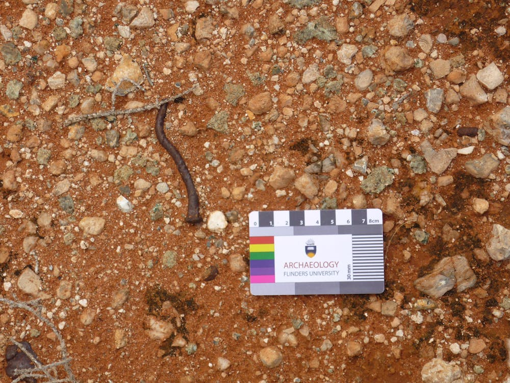
Finally, I’m here at Maralinga. Despite four phases of remediation, there is so much to catch the archaeologist’s eye. No doubt the last people in white radiation suits to leave the site after the 2000 clean-up thought all the residues of the hot yellow machines and bomb towers were safely interred in the burial mounds. I’m used to working at the scale of stone tools, though, and find the surface is scattered with small artefacts like broken ceramics and beer cans.
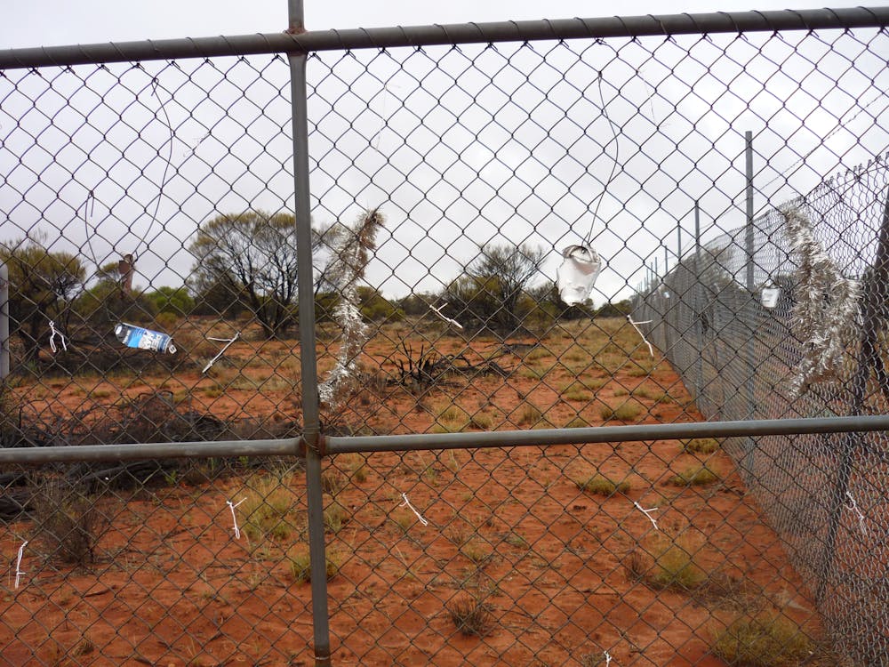
What really sticks in my memory are ephemeral traces of human presence. Along the wire of a perimeter fence, someone has looped bits of metal and twist ties in a line. A square grid has been drawn in the gravel near a radio tower. The tyre tracks of earth-moving machinery around and over the large burial mounds make me think of rover tracks on Mars.
This land is already a nuclear waste dump. The locations and proposals change, but the same apparent “emptiness” that brought rockets, nuclear tests and detention centres now attracts commercial interest in storing nuclear waste from other nations. It’s the end of a cycle that starts with the mining and export of Australian uranium. The redistribution of uranium is a very Anthropocene process, part of the dismantling and reassembling of the planet.
In the end it will all be buried, all become an archaeological site. Long after the molecular structure of the human-made materials has broken down, the uranium and plutonium will still be decaying. Future archaeologists may find it difficult to determine if these radioactive deposits are natural or cultural. Maybe the distinction will be irrelevant.
Epilogue: the wind
The story isn’t quite over yet, though. The Ediacara fauna gave their name to a new geological period, and while their relationship with contemporary species is still hotly debated, they have changed the way life on Earth is viewed.
The megafauna had largely disappeared by 10,000 years ago. The role of Aboriginal people in their extinction is also hotly debated, though archaeological evidence does not support the “overkill” hypothesis. New genetic studies are now pushing back the date of Aboriginal arrival in Australia to more than 60,000 years ago.
The Goyder Line is shifting south under the impacts of climate change.
Reg Sprigg, who died in 2008, established the Arkaroola Sanctuary in the Flinders Ranges. The Mars Society of Australia selected it as their primary Mars analogue landscape to pursue both planetary science and practical aspects of Mars colonisation.
After becoming the fourth nation in space with the launch of the WRESAT-1 satellite in 1967, Australia’s ambitions have languished. Woomera is still a busy test range, but we are no longer at the forefront of space exploration.
Maralinga has been handed back to its traditional owners. You can visit as a tourist.
The wind has been a constant theme. Once the dominant sound in the Ediacaran world, now it drives giant wind turbines supplying power to the state.
One planet’s past may be another’s future. The Ediacarans have vanished from South Australia, but deep time is always waiting to burst through the crusts of the surface. In the words of Ivan Southall:
In the most barren regions, the most lifeless regions, strange things happen after rain. Primitive crustaceans suddenly stir in the saline mud, reminding one of the dawning of time.
This essay first appeared in Griffith Review State of Hope, the 55th edition of Griffith Review.
The author thanks Hilda Moodoo, Wanda Miller, Eileen Wingfield, Andrew Starkey and many others who have generously shared their knowledge.