


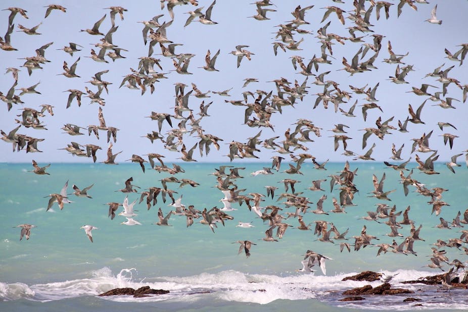
The world record for the longest non-stop unpowered flight is held by a bar-tailed godwit that travelled 11,600 km from Alaska to New Zealand in just over eight days.
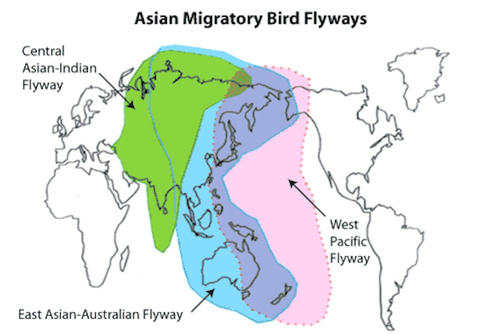
This bird’s remarkable journey was part of one of nature’s marvels, the annual migration of five million shorebirds between the Arctic and Australia along a bird superhighway known as the East Asian-Australasian flyway.
Now, in the southern autumn, many birds have left for their breeding grounds in the Northern Hemisphere. They will return in spring to escape the harsh northern winter.
But these birds are also highly threatened. For seven declining species on the flyway, populations have reduced by an average of 62% over the past 15 years, driven by habitat destruction, pollution and hunting. Now sea-level rise poses an even more uncertain future.
One way to protect these birds is to set aside protected areas where birds can move as seas rise. But there is a wide range of uncertainty in sea level projections, so how do we know which areas are most important to protect?
In research published this week in Proceedings of the Royal Society B, we used artificial intelligence that we developed to answer this question. We found that we could save at least 25,000 more birds than current conservation strategies.
Hungry birds
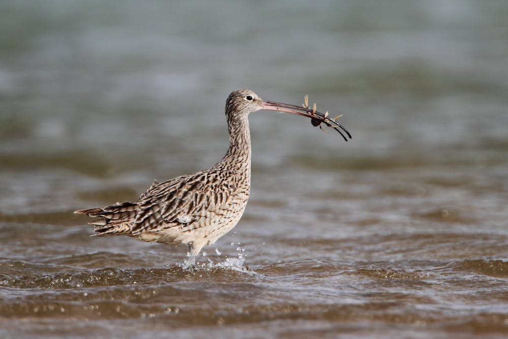
Like any long-distance travellers, most migratory birds need fuel to complete their journey. For shorebirds this means eating animals that live in coastal tidal flats (such as crabs, worms and bivalves) en route from birds’ breeding grounds to Australia.
However, coastal development is chewing up tidal flats at an alarming rate— already up to two thirds of tidal flat ecosystems in the Yellow Sea have been destroyed, with a further 2% disappearing annually. Exhausted birds arrive to find their feeding areas gone and must find an alternative or die trying.
Two shorebirds, the eastern curlew and curlew sandpiper, are likely to become the first migratory shorebirds to be added to the Australian threatened species list as a result of plummeting numbers caused by the rapid loss of their habitat.
Rising seas
On top of existing pressures — which also include pollution, disturbance and hunting — there is the threat of sea-level rise and extreme coastal weather events.
The low-lying coastal mudflats used by the birds are particularly vulnerable to sea-level rise, which is projected to increase by between 26 cm and 98 cm by 2100, with some studies suggesting seas could rise by more than a metre (and recent research suggests this process is speeding up).
This threat can be reduced by creating protected areas that give coastal habitats room to move as the sea level rises. However, although we know that bird populations are declining and have predictions for sea-level increases (even at local scales), uncertainty remains about the extent of sea level rise, future mitigation actions and what the impacts of that will be for bird populations.
Protecting species in a changing climate
Imagine a wetland visited by shorebirds in China’s Yellow Sea. Will it be there in the future or will it be flooded by rising seas? What will this mean for shorebird populations across the whole flyway?
This depends on a lot of factors, including the international response to rising carbon dioxide levels. We have to choose whether to protect the wetland even though we’re unsure about the future. Scientists have modelled scenarios that estimate which wetlands will flood under different scenarios, and can predict the most likely future scenario.
If we commit to a single sea level rise scenario and conditions change, the effort may be wasted because we protected the wrong place. It would be better if we could consider all scenarios when we choose a place to protect based on how likely they are to occur.
We are unlikely to be able to protect everywhere that we’d like to right now and it will take time to set up protected areas. We use a learning technique from artificial intelligence to decide when and where to put protected areas.
Our method works gradually, protecting the most important regions one at a time. We add new areas based on the best current information, accounting for the uncertainty in the future sea level rise. While we’re adding new areas, we compare how the sea level rise and bird populations are changing compared to scenario predictions and use that information to help us make better decisions in the future.
Because we learn as we go, we can adapt our protected area network to changing conditions. In this way we make the best decisions that we can right now, but also make sure that we keep our options open by considering all scenarios and learn as we go.
It’s not just sea level rise and birds that the algorithm can consider — it’s a general tool for making good conservation decisions in a changing environment.
We found that properly accounting for uncertainty in sea level rise can protect more birds than committing to a single scenario. Our simulations with 10 species found that accounting for model uncertainty protects 25,000 more birds than the current best method in the literature.
Where are the key areas?
Like previous studies, our work showed that protecting habitat in the Yellow Sea is critical to the future of our shorebirds, as a huge proportion of migrants stop in China or Korea as part of their migration.
However, although Australia accommodates fewer birds than the Yellow Sea, as the sea level rises, then Australia’s shorebird sites may have a more important role than previously thought.
Sea level rise is not uniform around the globe — different amounts of habitat are lost depending on the shape of the coast in each region. In Australia, a high sea level rise scenario will flood many of Australia’s coastal wetlands, with a big impact on migratory birds.
Sea levels are rising and will make life hard for our shorebirds. Artificial intelligence may provide the tools to help us overcome uncertainty and protect the habitat they need to keep on flying.