
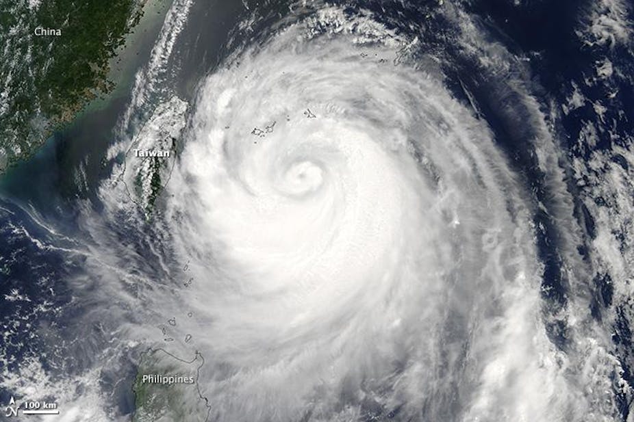
Typhoon Soulik struck Taiwan at the beginning of the weekend, killing two people before moving on into Guangdong in southern China, where 300,000 people have already been evacuated. Classed as a category 3 tropical storm according to the Saffir Simpson Scale, Soulik’s maximum peak sustained wind speed reached 145mph, into the realms of an “Extreme” or Category 4 storm.
Soulik is the seventh tropical storm in the Western North Pacific ocean basin this year, the most active tropical cyclone spawning region in the world. Nearly every year they havoc with agriculture, fisheries and transportation in China, Taiwan, the Philippines, Vietnam, Korea and Japan. Must it always be like this?
Predicting typhoons
The number of tropical cyclones in the Western North Pacific each year varies widely, from 19 tropical storms in 1969 to 43 in 1996. Early prediction can help warn the public of the severity of the typhoon hazard, reducing the risk of catastrophe and assisting emergency planning.
Seasonal forecasting of tropical cyclones has been under development for 20 years by experts at Colorado State University, University College London, City University of Hong Kong and the National Oceanic Atmospheric Administration, covering different ocean basins from the Atlantic to the Pacific.
Several atmospheric and ocean phenomena, for exmaple El Nino, the Sea Surface Temperature, and the Quasi-biennial Oscillation found in the tropical stratosphere are watched as indicators for tropical storms. Nevertheless, accurate seasonal forecasting that predicts where storms will land is far from perfect - though the assessment of how many can be expected is reasonably accurate.
Forecasting far ahead of typhoon season is unreliable, but the five-day forecast of typhoons due to make landfall and their “cone of uncertainty” - the area a moving typhoon is predicted to cover - are quite trustworthy. But the typhoons of the Western North Pacific are capricious, often moving abruptly and unexpectedly in any direction, and this complicates forecasts.
Every season is typhoon season
The Western North Pacific is known as the “warm pool”, and is the only ocean basin in which cyclones can form in any month of the year due to the warmth of the sea, at 26°C.
Typhoon catastrophes in this region are not necessarily because they are more frequent but because they are larger and more severe in intensity. For example, Super Typhoon Tip in 1979 had a central pressure of 870 millibars, a peak wind speed of 190mph and diameter of approximately 1,380 miles. Shallow coastal areas can be devastated by severe storm surge, flash flooding and landslides caused by heavy rain.
Existing studies of the region have shown a significant decreasing trend of cyclonic activity, but an increased number of high-intensity cyclones, with an increase of precipitation of around 20% within 100km of the storm’s centre under global warming scenarios.
A super typhoon in Asia (such as Vera in 1959 or Nina in 1975) could kill between 1000s and 100,000s of people. And even as the death toll has declined in recent years, the financial losses from typhoon catastrophes have increased. In Taiwan in 2012, typhoon Tembin killed only eight people but caused $8 million damage; typhoon Saola killed six but caused $27 million damage. Typhoon Morakot was the most expensive typhoon ever, devastating Taiwan to the cost of $2.3 billion damages in 2009.
Early warnings reduce vulnerability
Tropical cyclones build slowly. Continuous surveillance and monitoring via satellites, radar, aircraft reconnaissance, weather probes and automatic weather stations are undertaken. Information is gathered and shared at a regional level, such as through the Joint Typhoon Warning Centre and at national level, such as China’s National Marine Environmental Forecasting Centre. Each issues warnings on cyclone formation, intensity, speed and direction.
With early warning, people can evacuate from the path of approaching typhoons or take protective measures for themselves and buildings. Whether people choose to act in the face of a typhoon threat can be affected by many factors, including economic vulnerability, social norms, cultural preferences, and religious reasons.
In Asia, the real problem is building vulnerability. In China, rapid and unregulated property development in coastal cities exacerbates the problem. Those who live in low coastal areas may have buildings on stilts, or levees in front of their buildings. Construction deficiencies from weak builds or insufficiently deep piles driven into the ground leave buildings vulnerable. Levees can be overtopped or even destroyed by high storm surges generated by super-typhoons, particularly those occurring with high tides. Natural barriers such as salt marshes have been used to weaken the strength of storm surges, but they are not impassible.
Catastrophe modelling is the solution
Disaster management for typhoons lies on the assessment of potential damages. Sharing the risk through insurance may be the solution for those living with typhoons.
Hurricane catastrophe models have in development for decades, such as AIR Worldwide, EQECAT, RMS, and public-private collaborations such as the Public Hurricane Loss Projection Model based in Florida International University. Unfortunately such models for typhoons in the Western North Pacific ocean basin are still at an early stage, and more improvement is needed before they are comparable.