
What would the world look like if we could decide – globally and collectively – to allocate all our land in the optimal way? Where would we grow food and find water, and what areas would we leave to nature?
A team of researchers in Germany have calculated optimal land use configurations that could work under future climate conditions. Their study in the journal PNAS, suggests that rejigging where we grow food could almost triple crop production, while maintaining supplies of freshwater and stores of carbon.
It’s a radical suggestion that isn’t likely to ever happen. But a thought experiment like this provides an insight into the scale of transformation that may be required to maintain a healthy planet while adapting to a changing climate and a growing population.
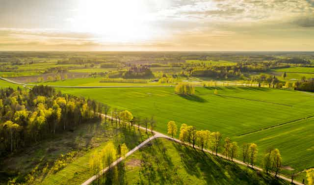
After all, humans transforming the natural landscape into something else – what’s referred to as land use change – is a key driver of biodiversity loss. With 8 billion humans to feed, more than a third of the world’s land surface and about three quarters of freshwater resources are now devoted to crop or livestock production leading to a significant drop in the abundance of many native species.
The new study calculates the optimal configuration of global land-use under different climate change scenarios until the end of this century. It targets three key indicators. First, the total carbon stored in trees, wetlands and so on, which is an indicator of climate regulation and mitigation. Second, crop production as proxy for food supply. And third, available runoff (excess water the ground cannot absorb), indicating freshwater availability.
The study’s authors then used an optimisation algorithm to identify how land could be best allocated to reach a point at which the global totals of each of these three objectives could not increase without declines in the other two – that is, the optimum use of land.
Forests here, crops and pasture there
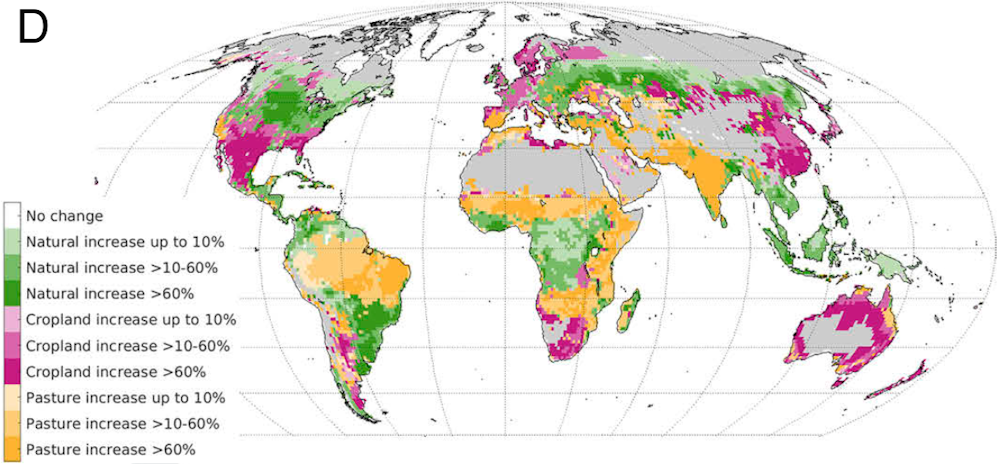
What might this mean in practice? The research identified some global priority areas where natural habitats could regrow. Those are predominantly areas currently used for farming that would, in their natural state, have been forests.
To compensate for the regrowth of forests, the optimisation suggests a significant expansion of croplands in temperate regions including the southern US and Mexico, western Europe, South Africa, eastern China and also the coastal regions of Australia.

In the optimisation, new pasture would be created from cropland in India and from natural land in eastern and southern Africa and in regions south of the Sahara.
More controversially, the optimisation suggests converting natural land in the Amazon basin into pasture. This is because long term climate modelling suggests the rainforest is becoming drier anyway and even risks “tipping” into more savanna-like conditions.
Balancing multiple ecosystem services
Carbon storage, freshwater and food supply are important, but they are just three of the many “ecosystem services” provided to humans by nature. If others – such as flood management, pollination or even human recreation – were factored in, it might paint a very different picture and shift the optimisation boundaries.
The authors briefly mention the potential impact that large scale land use conversions may have on biodiversity, for instance, a crucial aspect of these services. But an exercise like this is unable to capture the nuances of impacts on threatened species let alone on the movement and establishment of invasive species.
It’s also tough to see the suggested land use as feasible or pragmatic when geopolitical and socioeconomic factors tend to drive decisions on what to do with land. For example, the optimisation suggests more cropland in most of Great Britain, with parts of Scotland and southern and eastern England left to nature. But this would require significant policy and socio-culture change in a country where 52% of land is already enclosed farmland and only 11% is woodland.
Only a very brave politician would suggest abandoning British farms, or taking iconic woodlands or moorland grazed by sheep and turning them into wheat fields.
The challenges might be even greater in a country like India, which the optimisation suggests should be converted to pasture. This would be a radical overhaul in a country where 70% of rural households still depend on agriculture, predominantly growing crops.
The authors acknowledge that such drastic land-use changes over such extended regions are unrealistic. East Africa won’t suddenly become a huge livestock farm, and northern states in the US won’t be reforested overnight. This remains a theoretical exercise. For land use optimisation to succeed in practice, any transformations will need to consider both the local policy and practice context of each region.
This study is, however, a good example of the sort of big picture thinking required in the longer term, and provides a theoretical framework that gives us an inkling of the direction and scale of change that may eventually need to be considered.
Don’t have time to read about climate change as much as you’d like?
Get a weekly roundup in your inbox instead. Every Wednesday, The Conversation’s environment editor writes Imagine, a short email that goes a little deeper into just one climate issue. Join the 20,000+ readers who’ve subscribed so far.