

On May 21, a ceasefire was agreed to between Israel, Hamas and Islamic Jihad, putting an end to a bloody 11-day conflict. Despite the relative calm that has ensued, the violence of these past weeks across Israel-Palestine has unveiled distinct urban fronts.
The conflict was triggered in the Sheikh Jarrah neighbourhood of East Jerusalem and the al-Aqsa Mosque on the Temple Mount in the Old City of Jerusalem. It took hold of the Israeli so-called mixed cities, such as Jaffa and Lod/al-Lidd, and engulfed Gaza, where Israeli air raids retaliated against the rockets Hamas fired on cities including Tel Aviv.
For some, this felt like civil war. As our research demonstrates, these urban frontlines reveal how urban planning itself is weaponised.
Across the territory, cities and towns are controlled and demographically engineered by the state. This occurs on both sides of the Green Line (the 1949 ceasefire boundary between the West Bank and Israel, which Israel rejects as indefensible), in the West Bank itself and in the Gaza Strip. Increasingly seen as an apartheid regime, the government’s goal throughout is to encourage Jewish expansion and restrict Palestinian growth.

The mixed city
Heterogeneity is a basic urban condition. The term “mixed city”, widely used in Israel to describe an urban conglomeration occupied by Jewish and Arab communities, suggests a diversified and well-integrated society.
The reality, however, is that Jewish and Arab residents are divided – both spatially and socially – through an ongoing Judaisation of the territory. The state apparatus is actively spreading Jewish populations while dispossessing Palestinian populations.
This process is rooted in Israel’s territorial and urban history. After the Palestinian Nakba (“the catastrophe”) and the establishment of the Israeli state in 1948, the Palestinian citizens who stayed became a marginalised minority. Many of their cities, meanwhile, were transformed by Israeli Jewish town planners and residents.
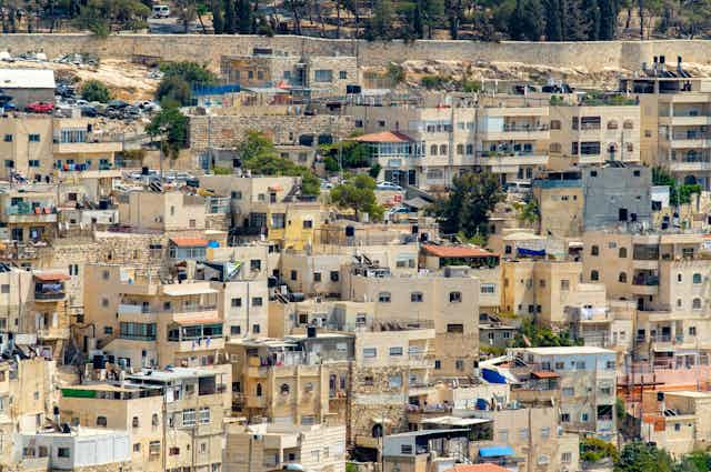
The example of Lod/al-Lidd is instructive. The 1948 war saw 250 Palestinians killed in the city and a further 20,000 become refugees.
The Israeli Military Administration initially placed the 1,030 people who remained under strict surveillance in an enclosed area known as the Sakna. The city’s Palestinian houses and land, meanwhile, were expropriated by the state, who redivided and rented them out to Jewish immigrants.
From the 1950s, the state drew up a master plan for the city, now known as Lod. Intensive demolition (of the historical urban fabric) was followed by extensive reconstruction (of modernist housing blocks, infrastructure and services) to the benefit of Jewish immigrants. Palestinian housing and infrastructure needs, however, were overlooked.
Waves of internally displaced Palestinians have since settled in Lod, from Bedouins whose lands in the Triangle region were expropriated to Palestinians expelled from Gaza and the West Bank for collaborating with the Israelis in the 1967 war. If only 9% of the Lod population was Palestinian in the 1950s, today they account for almost 30%.
The Israeli state, in its attempts to control what it terms the “demographic balance” has continued to actively settle Jewish immigrants in the city. It also supports a growing number of settler organisations developing residential projects for Jews only. This is happening in other mixed cities too, including Jaffa.
The divided city
After the 1948 war, Jerusalem was divided by a walled border zone separating Israel from Jordan. When Israel occupied and annexed East Jerusalem in 1967, the state proceeded to reshape the city on both a territorial and a demographic level.
A massive construction programme of Jewish settlements and neighbourhoods pushed beyond the city’s outer ring. Palestinian development, however, was stifled. The state demolished housing, limited Palestinian construction, allowed unequal distribution of infrastructure (including schools, roads and sewage systems), and prevented Palestinian immigration to the city.
Today, East Jerusalem accommodates around 40% of the city’s Jewish population, up from 4% in the early 1970s. And supposedly neutral urban trends (privatisation, gentrification) only serve to further contain and control Palestinian urban space.
Even touristic planning is co-opted, as our research into the contested archaeological site of Silwan shows. Despite the fact that scholars agree there have been no archaeological finds proving the biblical king David’s presence, tourists flock to the site. The dig has seen much Palestinian property acquired in bad faith. The tourism industry that has arisen around it, meanwhile, has state backing.
In Jerusalem’s Palestinian neighbourhoods such as Sheikh Jarrah, real-estate disputes belie how the state uses the courts to further its settler-colonial project. The recent violence was triggered, in part, by the threatened eviction of Palestinian families from their homes in favour of the Jewish settler organisation Nahalat Shimon.
Israel’s violence is enacted through discriminatory land-use policies, court rulings and planning strategies. The aim is to maintain a solid Jewish majority in the city.
The disconnected city

With the occupied territories of the West Bank and the Gaza Strip, the aim is to create well-connected Jewish settlements that link into one Israeli-controlled territory. Palestinian space, meanwhile, is an ever-shrinking territorial archipelago of disconnected enclaves.
Checkpoints and roadblocks restrict Palestinian movement in the West Bank and maintain its separation from the Gaza Strip which is, in itself, tightly controlled by Israel.
Since 2007, the state has implemented an air, land and sea blockade, adapting the colonial effort to limit Palestinian space into a large-scale project, only this time there are no settlers.
Instead, with 2 million inhabitants, around 70% of whom are refugees, Gaza is one of the most densely populated areas on earth. Basic necessities (medicines, fuel, food and building materials) are in constant deficit. It is also one of the most polluted: 97% of its drinking water is contaminated by sewage and salt.
This is in addition to Israel’s brutal destruction of Gaza’s natural resources and the built environment.
The Israeli state aims to expand, connect and invest in Jewish spaces while dividing, shrinking and destroying Palestinian spaces. Urban planning is used as an inherent part of this endeavour, designing density, vulnerability, separation and displacement into the very fabric of Palestinian urban areas.