


Partha Mukhopadhyay and Shamindra Nath Roy from the Centre for Policy Research co-authored this piece.
The reduction in the number of individuals commuting and travelling have without a doubt decreased the propagation of the coronavirus Covid-19 virus, as indicated by recent research.
However, several articles underline the necessity to take into account urban and regional mobilities to better understand the emergence of infectious diseases in particular territories. The difficulty for the research community in considering such data contributes to the vulnerability of societies, notably in countries like India. However, preliminary results from ongoing research using social network data could be a first step to change this.
India under lockdown
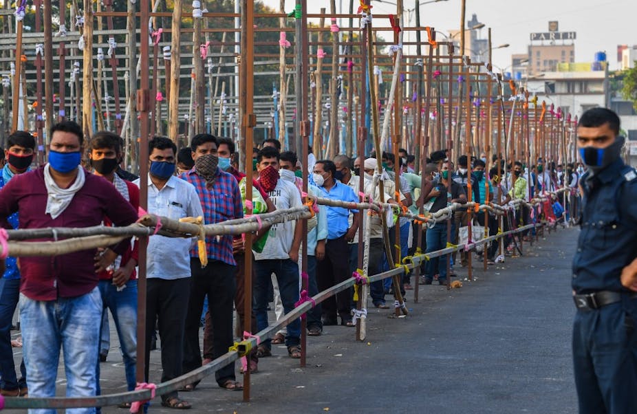
India is divided in 32 states or union territories with a total population of 1.3 billion. The country’s economic development has led to the development of significant intra- and inter-regional mobilities. In addition to workers of the unorganised sectors who are currently stranded, metropolitan regions of India are at the centre of major daily flows that have significant consequences on pathogens diffusion such as dengue and Covid-19.

Facebook Data for Good
To better understand mobility patterns during this period, we accessed Facebook mobile users’ data provided through the company’s Data for Good platform. Keeping in mind the potential digital divide, we aimed to observe the changes induced by lockdown on mobility patterns of more than 28 million users (approximately 3% of the total population 18 and over). With the most up-to-date information, this data helps us understand dynamically where the people are. Measured every eight hours (00:00AM, 8:00AM, 4:00PM GMT), it provides a grid with the number of persons who moved from a given cell to another between two time periods.
The mode of detection is passive, fully anonymised and no individualy identifiable information is provided. For our purpose, we combined it with data from the 2011 census of India (the next release is scheduled for 2021) since it constitutes a solid basis to add further socio-demographic insights.
A decrease of commuting at the national level
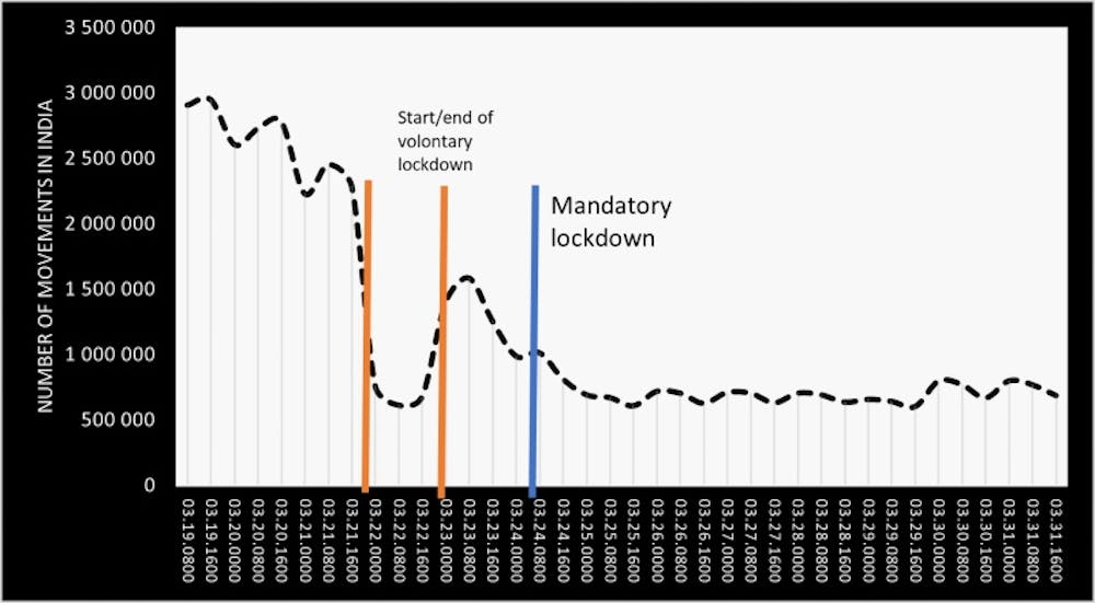
At national level, the data reveal that the number of individuals who changed location between the eight-hour gap decreased massively after the lockdown (figure 1).
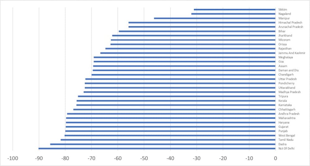
This global pattern hides a more complex one at state level. The mobility of individuals shrank by almost 90% in Delhi NCT, while in other states, it fell by only 40% (see figure 2).
Overall, the number of users per state does not change significantly, as indicated in figure 3.
Cities lose population while rural areas gain
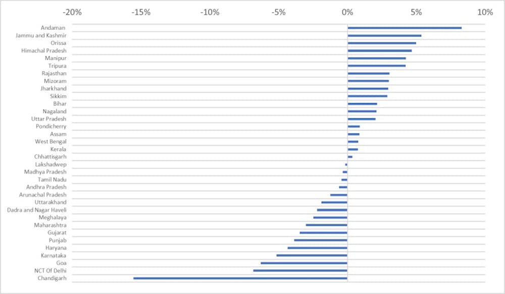
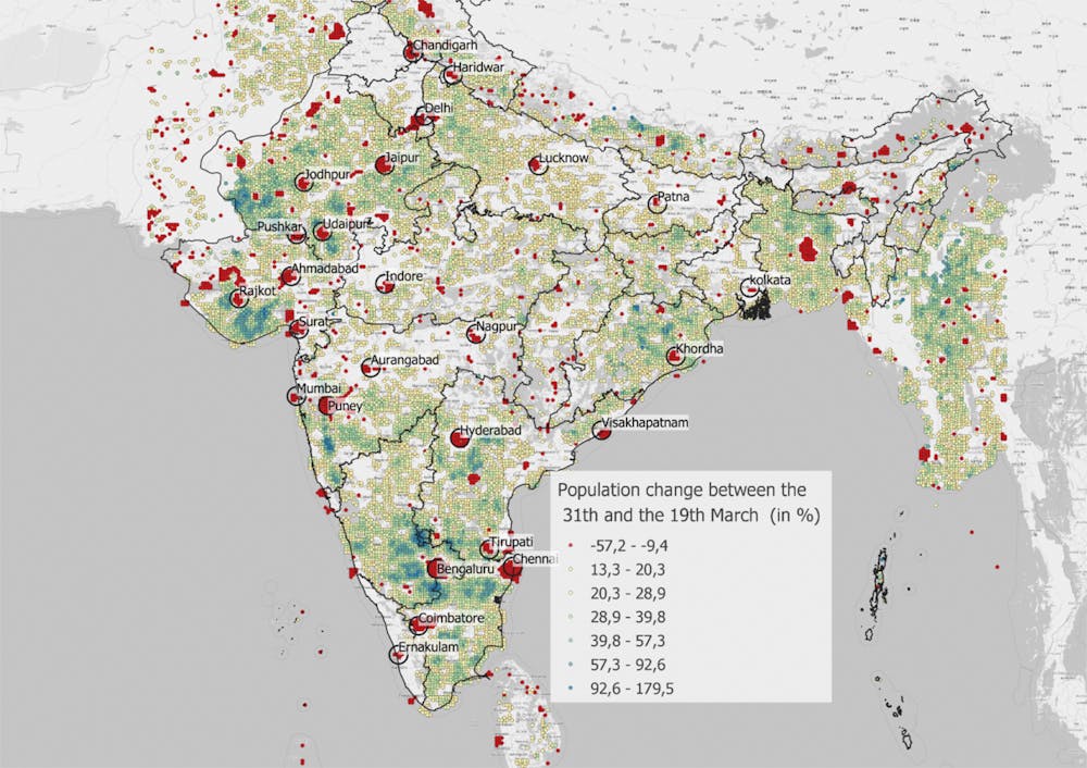
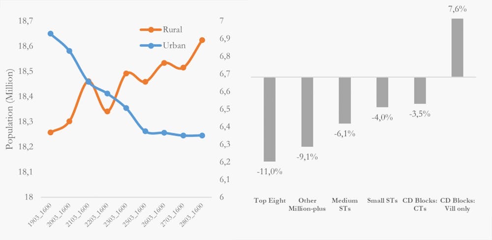
The only states that observed a significant decrease of population (Facebook users served as a proxy) are Chandigarh, Goa and the Delhi NCT. Delhi has high level of commuting, and cities in general lost 7% of their users, which would represent around 1 million individuals.
The map presenting the difference of population reveals a clear structure: cities are losing population, while rural areas are gaining some.
This is confirmed by graphs 3 and 4: rural population increased by 7% while cities lost between 4% and 11% according to their typology (from metropolis to small census towns). As revealed by map 1, neighbouring countries seem to experiment the same pattern, with cities losing a significant share of their population. Bangladesh being archetypal.
Our data suggest that prior to the lockdown, cities are at the centre of significant population shifts during the day from neighbouring areas. Because of the lockdown, millions of individuals no longer commute to them. In that context, the population increase in the rural areas surrounding cities is the result of the abrupt stop of daily movements toward city centres.
Unusual incoming mobilities
However, some areas concentrate cluster of localities experimenting unusual incoming flows during this crisis: this is the case in West Rajasthan, South India (around Bangalore, Chennai and Madurai), the mountains located in the North of Delhi and Orissa.
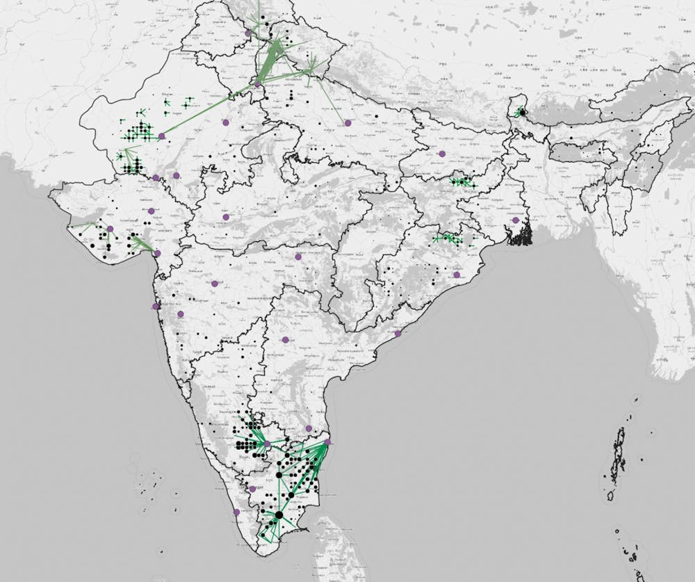
Long-distance relocation of individuals explain the exceptional increase in incoming mobilities from Delhi to the mountains in North India. In Rajasthan and Odisha, they are the result of local adjustment of residence mainly toward remote villages. In South India, an exodus from cities also occurred, but was limited to the state level. Notably, some Bangalore and Chennai residents rushed to distant and small localities and migrant workers went back to their place of origin.
Our analysis suggests that up to the end of March, there was no significant increase of population in the poorest states, such as Bihar, Jharkhand or Uttar Pradesh, a source of migrant workers. Their mobility has been severely constrained and delayed by the lockdown: railways and buses stopped, and interstate police roadblocks were in place. An exception is Uttar Pradesh, which has its border within the Delhi metropolitan region across the Yamuna River. We might be able to better see this return migration pattern in the coming weeks.
Pointing up the next clusters
This first exploration of Facebook’s Data for the Good platform in India reveals that the lockdown was clearly effective in reducing mobility. While cities are losing daily commuters, some long-distance mobility was detected, particularly during the first week, as other research suggest. These movements could point out the next Covid-19 clusters to come.
A future collaboration based on an ongoing project between the Centre National de la Recherche Scientifique, Institut Pasteur, India’s Center for Policy Research and UK Liverpool University will help to define if the lockdown impacted the pandemic curve and the spatial diffusion of Covid-19.
Our preliminary results show how using real-time social-network data on population movements can help to understand how the virus spread on local and regional levels. These in turn can point us toward what confinement strategies will have the most impacts on virus diffusion, and thus reduce significant humanitarian effects and social and economic impacts caused by a total lockdown of population.