

You may have noticed that some weather forecasts have started mentioning the chances of seeing an aurora, also known as northern lights. Just as the atmosphere of the Earth gives us terrestrial weather, the nearby, vast atmosphere of the sun gives rise to space weather – triggering events such as auroras. Many weather institutes around the world now provide forecasts of the weather in space because of the hazard it poses to services we rely on, such as satellite positioning services, power distribution and communications.
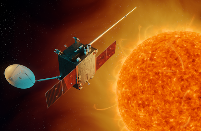
But forecasting services are only as good as the modelling and the data that underpin them. Currently, space weather forecasting satellites typically record this data from their orbit around the Earth. However, working with the UK and the European Space Agencies, we are developing a new satellite, dubbed Lagrange, that could significantly improve space weather predictions. It will venture further away from our planet than any other dedicated space weather mission, getting a much a better view of what is going on.
Extreme space weather storms now feature on the national risk registers of many countries as one of the greatest natural hazards. In the UK, it comes after pandemic flu, coastal flooding and effusive volcanic eruptions. As a result, the Met Office has been monitoring space weather 24 hours a day, every day of the year, since 2014 in order to provide forecasts to a range of customers. Today, severe space weather storms are estimated to have the potential to cause billions of pounds of damage across Europe.
Stable points in space
Lagrange will carry all the equipment needed to characterise the activity of the sun that determine the conditions in its atmosphere. There are instruments to measure the magnitude of bursts of X-rays called solar flares and the gusty and variable particle flows and magnetic field of the solar wind. Others will detect gigantic eruptions of plasma known as coronal mass ejections that dwarf the Earth when they arrive, with streams of particles moving at near light speed.
The whole suite of instruments is cleverly chosen to enable us to monitor and forecast space weather from the sun impacting on the Earth. In particular, it will measure the magnetic fields of the sun that are responsible for creating space weather in the first place and estimate how long it takes the worst space weather to reach the Earth.

The really new aspect of the mission though is where it will be placed. Rather than being in orbit around the Earth, the spacecraft will be sent to a “Lagrange point”. Massive objects, such as planets, have a strong gravitational field that enables us to put satellites into orbit around them. What is less well known is that that there are positions where the gravitational forces of objects such as the sun and the Earth (including the moon) and orbital motions of a spacecraft interact to create a stable location. When it comes to the sun-Earth system there are five such points, and they are called Lagrange points after the Italian-French mathematician Joseph-Louis Lagrange.
Our mission will hover at the fifth Lagrange point (L5), sitting at one vertex of an equilateral triangle that has the sun and the Earth at its other two points. Putting a spacecraft at L5 essentially gives space weather forecasters a side-on view of the sun that will enable us to see what eruptions are heading towards the Earth. Another advantage is that the spacecraft gets to bathe in solar wind streams that will be directed at the Earth a few days later, due to the rotation of the sun.
Measuring the solar wind flow a few days before it points at the Earth will improve the forecast of background conditions by 50%, helping us accurately forecast an “all clear”. It will also tell us whether Earth-directed coronal mass ejections will be sped up or slowed down by the solar wind through which they move. Together with the side-on view, this will help us more accurately predict the arrival of these large eruptions at the Earth. In fact, it should double the accuracy of the forecast time compared to the current methods.

The ultimate aim of Lagrange is to improve the resilience of the planet to extreme space weather risk by enabling more accurate forecasts. However a forecast is only useful if those impacted by the hazard know what to do when an alert is issued. The academic community is supporting Lagrange by also responding to this educational space weather need, providing new teaching programmes to enable the key people to gain necessary knowledge and skills to tackle any extreme space weather events in the future.
Responding to extreme space weather can take many forms, but the best protection is to be prepared. If we know a major space weather event is about to happen, then satellite operators can put satellites into “safe mode” to ride out the storm. Meanwhile electricity grid operators can stabilise the grid by reducing repair work and asking high-usage customers such as factories to reduce activity. They can also keep a close eye on the performance of the high-voltage transformers at electricity substations to make sure they are not overheating.
Lagrange is undergoing development at the moment, but all going well it should will launch in the mid-2020s. Given the cost of space weather to our economy, it can’t come a moment too soon.