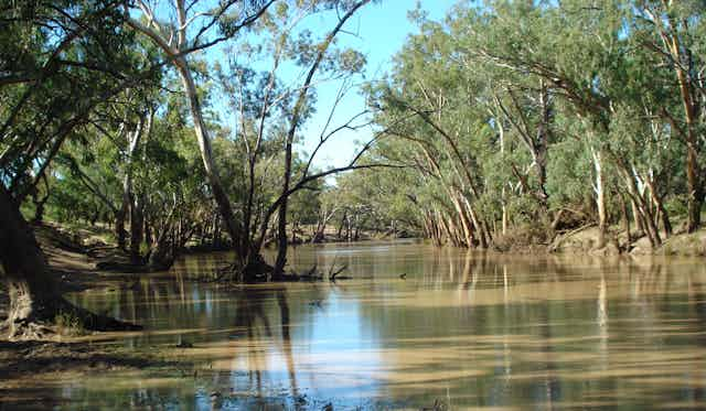

During droughts, Australia’s inland rivers dry up, leaving waterholes as the only wet places in a parched landscape. Fish, turtles, crayfish and other aquatic animals retreat to these vital refuges.
But our research, published today, reveals these waterholes are in danger of filling up with eroded soil from farms. This is putting a big squeeze on life in the river.
When drought breaks, the water flooding into the river carries soil along with it. In theory, soil deposited in waterholes could be flushed out again by large floods.
Studies in the 1990s suggested as long as floods continued to occur, waterholes would maintain a natural balance of sediment. But these studies focused on the Cooper Creek, in the Kati Thanda (Lake Eyre) Basin, where waterholes have a sandy base underlying clay-dominated soil that can be easily washed out again. Many Australian rivers are different. So what happens elsewhere?
Our new research investigated waterhole infilling in the Moonie River, in the northern part of the Murray Darling-Basin. The Moonie catchment has experienced extensive clearing of native vegetation for sheep and cattle grazing. Unlike some neighbouring catchments, the upper and middle portions of the river have minimal water extraction and so their flow patterns are relatively “natural”. It’s a true “dryland river”, flowing only after infrequent rain events. During long periods with no flow, waterholes become the only remaining wet habitats for aquatic animals to survive.

Read more: Australia’s inland rivers are the pulse of the outback. By 2070, they’ll be unrecognisable
Poking at sediment to understand waterholes
Waterholes in the Moonie River can be more than 5 kilometres long, up to 5 metres deep, and teeming with life. Kingfishers, whistling kites and parrots create a symphony of sound while fish occasionally break the surface of the murky water.
We studied three of the deepest waterholes in the Moonie River, as they are the ones that last longest in droughts. Our initial method was simple. Using metal rods, we probed the soil’s depth at evenly spaced points along the waterholes. Our first survey revealed all three waterholes had accumulated at least a metre of soil, with one site showing more than 2.5 metres of infilling, significantly reducing its depth.
To determine the rate of sediment accumulation, we used radiocarbon dating. This technique is commonly used for dating objects thousands of years old such as the Lake Mungo skeletons. However, nuclear weapons testing in the 1950s introduced new radioactive material including radiocarbon into the atmosphere worldwide. By analysing radiocarbon in the Moonie River sediments, we could estimate their age.
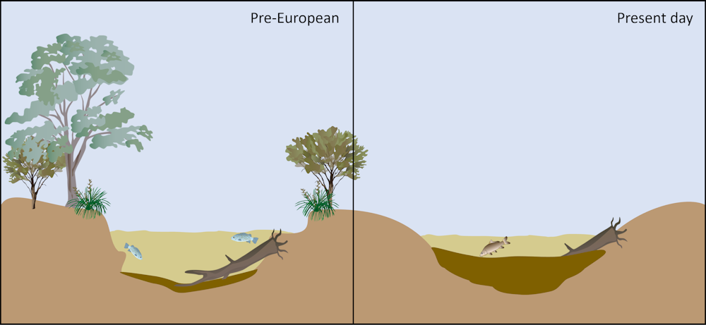
Our sediment dating revealed that, in places, more than two metres of soil had filled the deepest waterholes since the 1950s. Before European occupation, it would have taken thousands of years to deposit this much soil. Our research suggests sediment infilling also sped up over the past few decades.
The accumulated soil reduces the waterholes’ depth, preventing them from holding water for as long as they used to during droughts. Our modelling indicated this reduction has shortened the duration waterholes can hold water by almost a year at some sites, bringing them dangerously close to complete drying during the longest droughts.
Do floods remove soil from waterholes?
However, two significant questions remained: does sediment get removed after a large flood? And if it does, does material from upstream simply get dumped downstream? To answer these questions, we needed some luck and a knowledge of cocktails.
In 2010 and 2011, the Moonie River experienced two very large floods. This gave us the perfect opportunity to find answers. We repeated our waterhole surveys and found even after big floods, there was still a minimum of 1 metre of sediment across most of the bottom of these waterholes, with much deeper sediment in places.
The missing piece of our puzzle was to determine whether the sediments were mixed together, like a margarita, and deposited by a single flood, or if they were layered, resembling a B52 cocktail (another connection to nuclear bomb testing).
To unravel this, we examined how the sediment had changed since before the floods. We observed distinct layers, like those in a B52 cocktail, indicating the sediments had been deposited over a series of flows and floods since the 1950s, rather than solely after individual floods.
How can we solve this problem?
We need to address the imbalance between eroded soil supply and the river’s capacity to transport sediment downstream.
In the Moonie River, water extraction for human use is minimal, so the problem is unlikely to lie with the river’s flow regime. The main culprit is an increased supply of sediment.
That means the solution lies in better catchment soil management. We need to stop so much soil washing into the Moonie River. This requires further research to find the main sources of soil that fills waterholes. Then determine the most effective ways to prevent erosion and reduce the amount of soil entering the river. This approach also helps preserve precious soils on agricultural land. In some exceptional cases, more extensive engineering solutions may be necessary to restore waterholes.
Given climate change projections for more frequent and longer droughts in the region, taking action to restore and preserve the function of waterholes in dryland rivers like the Moonie becomes increasingly crucial. These actions are essential for safeguarding the diverse aquatic animal life and the people that depend on waterholes for survival during droughts.