
You’ve probably heard El Niño brings hot and dry weather to the eastern states, but what about the rest of Australia? Are we all in for a scorcher this summer?
El Niño is what scientists call a climate driver. But it’s just one of many.
These climate drivers control year-to-year variations in the weather. Some years are hotter and drier, while others are cooler and wetter.
Australia is particularly prone to weather whiplash because our continent is buffeted by climate drivers to our north, south, east and west. The dominant driver in your state may be one of the lesser-known influences.
East: El Niño Southern Oscillation
The El Niño Southern Oscillation (ENSO) is the resident climate driver in the Pacific Ocean and the driver with the biggest influence over Australian weather. Differences in sea surface temperatures and winds across the Pacific determine whether we swing towards El Niño (the boy) or La Niña (the girl).
During the El Niño phase, sea surface temperatures near South America are warmer than normal and they are cooler than normal off the coast of eastern Australia. Additionally, trade winds that blow from east to west across the Pacific weaken.
El Niño brings hotter daytime temperatures, but often cooler nights. That’s because reduced cloud cover allows more heat to escape into space overnight. So the same process that increases the chances of heatwaves can also raise the risk of frost in Western Australia, New South Wales, the Australian Capital Territory and Victoria.
Australia as a whole is typically drier during an El Niño event. In the tropical regions, El Niño can delay the onset of the monsoon and reduce the likelihood of tropical cyclones. In the southern states, the hot and dry conditions increase the chance of intense bushfires.
La Niña is the opposite phase. Waters off eastern Australia are warmer than usual, increasing the chance of tropical cyclones and an earlier start to the monsoon for WA, the Northern Territory and Queensland.
So what does El Niño do to the weather in your state? Hover over your state in the interactive map to find out.
Read more: We're in an El Niño – so why has Australia been so wet?
West: Indian Ocean Dipole
The Indian Ocean Dipole is like ENSO’s Indian Ocean cousin. A positive Indian Ocean Dipole is declared when ocean temperatures near Africa are warmer than normal and ocean temperatures off the coast of Sumatra are cooler than usual.
A positive dipole tends to bring warmer and drier conditions, particularly to western and central Australia. A negative Indian Ocean Dipole is the reverse and is associated with wetter than normal weather and an increase in northwest cloudbands.
North: Madden-Julian Oscillation
The Madden-Julian Oscillation is a pulse of storms that start in the Indian Ocean, travel over Northern Australia and Indonesia and die in the Pacific Ocean. Ahead of the pulse, the air sinks, causing sunny and dry weather. Under the pulse is high storm activity and typically heavy rainfall.
We describe the Madden-Julian Oscillation based on whether the pulse of storms is active or inactive and where the storm activity is located on its path between the Indian and Pacific Oceans. As well as causing rainfall, the Madden-Julian Oscillation can control the timing of the monsoon onset and tropical cyclone formation.
South: Southern Annular Mode
The Southern Annular Mode controls the north and south position of the westerly winds that whizz around the globe in the Southern Ocean. When the winds are further north than usual, we call this the negative phase. But when the westerly wind move towards Antarctica, we call this the positive phase.
The phase of the Southern Annular Mode affects how many weather systems, like cold fronts, make landfall over southern Australia. A positive mode may also draw tropical moist air south, which happened in 2022 during the extensive flooding over eastern Australia.
Climate drivers control the odds, but not the result
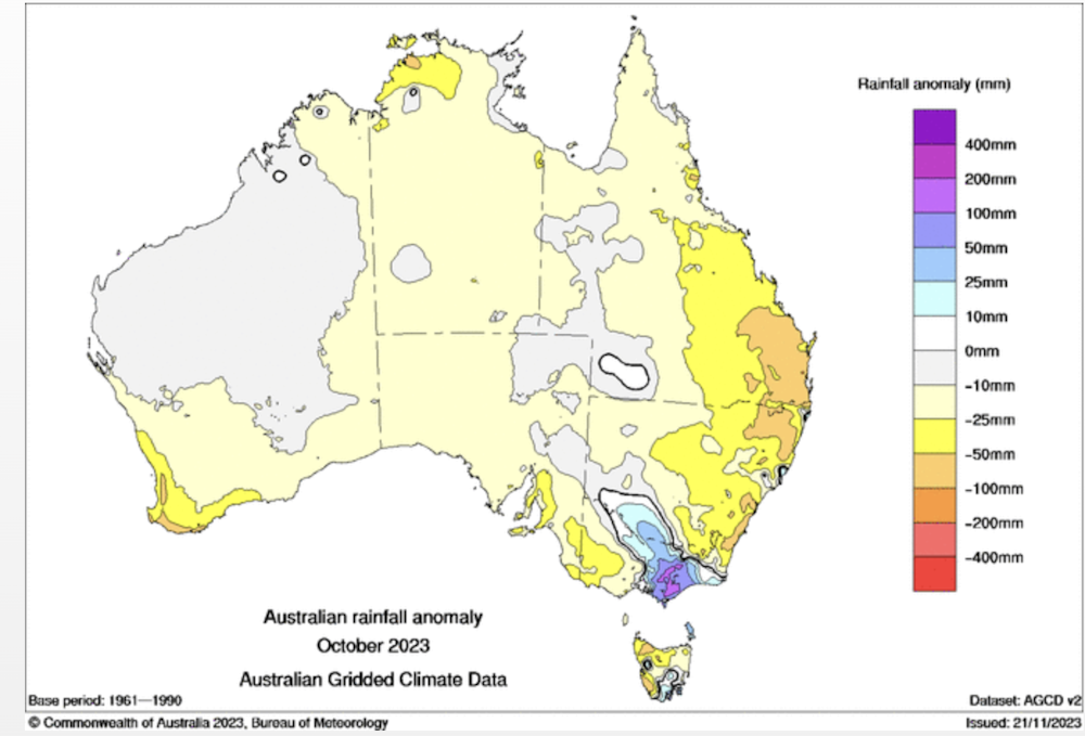
These four key climate drivers affect the weather on average (over months and seasons), but they do not dictate the exact day-to-day weather we experience. As the Gippsland region of Victoria saw in October, heavy rainfall can still occur during an El Niño.
Climate drivers are like a football coach. They can select the best players and develop ingenious strategies, but that doesn’t guarantee a win every time.
Players can get injured on the field or simply have a bad game. These uncontrollable factors are challenging to predict and may change the result from what we would expect. Scientists call this stochasticity. The climate drivers are the football coach, but the day-to-day weather systems are the players.
The Bureau of Meteorology releases an update on all of these drivers every two weeks. The update explains which drivers are currently active and the forecast for the next few weeks.
So, if you are wondering why the weather is cooler during summer, or it’s raining in the middle of the dry season, perhaps take a look at which driver is steering Australia’s weather at the moment.
Read more: Why are so many climate records breaking all at once?