


There’s no sign of it on the surface, but the water at the bottom of the estuary of the Lower St. Lawrence River is running out of breath. There is less and less dissolved oxygen in this deep water, and this deoxygenation cannot be fixed.
Our research focuses on a range of marine geochemistry projects, including the causes and consequences of low oxygen, called hypoxia, in the deep waters of the Gulf of St. Lawrence and of the estuary.
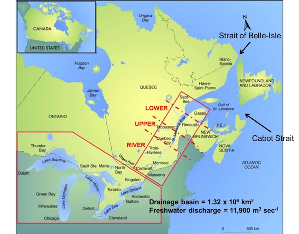
The colossal St. Lawrence River
An estuary is a coastal body of water, where freshwater and salt water mix, that empties into an ocean. The St. Lawrence estuarine system is the largest on Earth.

This article is part of our series, The St. Lawrence River: In depth. Don’t miss new articles on this mythical river of remarkable beauty. Our experts look at its fauna, flora and history, and the issues it faces. This series is brought to you by La Conversation.
The system connects the Great Lakes to the Atlantic Ocean, draining nearly 25 per cent of the world’s freshwater reserves. The average freshwater discharge at Québec City is about 12,000 cubic metres per second, the second-largest freshwater discharge in North America, second only to the Mississippi River.
The St. Lawrence estuary begins at the eastern tip of Ile d’Orléans, east of Québec City. This is where the first traces of salt water can be found. It then extends over 400 kilometres to Pointe-des-Monts, where it widens and becomes the Gulf of St. Lawrence, an inland sea that is connected to the Atlantic Ocean by the Cabot Strait and the Strait of Belle Isle.
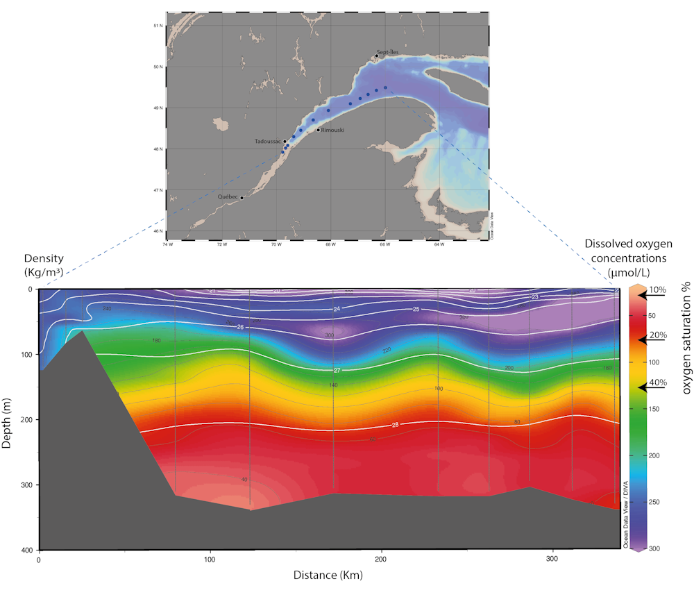
The estuary is separated into two segments: The upper estuary, which extends from Île d'Orléans to Tadoussac, near the mouth of the Saguenay Fjord, and the lower estuary, which runs from Tadoussac to Pointe-des-Monts.
The upper estuary, or fluvial estuary, is relatively narrow (two to 24 kilometres wide) and shallow, generally less than 30 metres deep. There is a strong horizontal salinity gradient, a gradual increase in the amount of dissolved salt in the water.
From a vertical perspective, the water column is well mixed or weakly stratified. A water column is stratified when water masses of different densities (determined by temperature and salt content) are superimposed vertically. These water masses cannot mix easily without a significant input of energy.
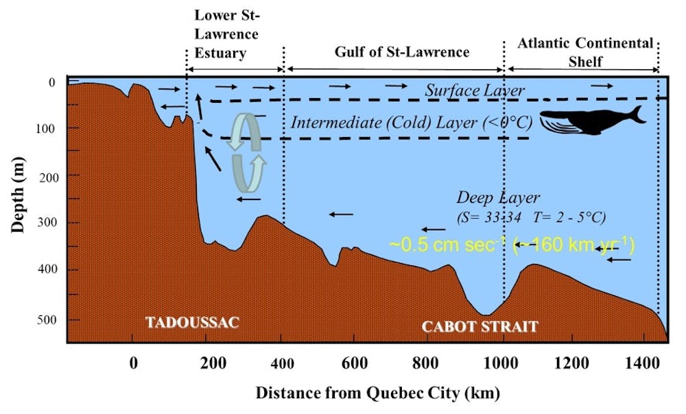
The lower estuary, or marine estuary, is much wider (30 to 50 kilometres wide) and deeper. At its centre, a 1,240-kilometre long submarine valley plunges to a depth of more than 300 metres. This is the Laurentian Channel, and it’s where deoxygenation is occurring.
Three layers of water
To understand the causes of deoxygenation, it is important to know that the water column in the maritime estuary and the gulf is composed of three layers:
A surface layer, 0-30 metres deep, of relatively warm and brackish water that flows toward the Atlantic.
A cold intermediate layer, 30-150 metres deep, that is almost as salty as sea water. It forms in the winter in the gulf and moves up the estuary. This layer contains 32 grams of dissolved salts for each kilogram of water. Lake or river water typically contains less than 0.01 grams per kilogram, and sea water contains nearly 35 grams per kilogram.
Dense, deep water exists below 150 metres. These are warmer (between 2 C and 7 C) and saltier (salinity between 33 and 35 grams per kilogram). These waters form on the continental slope near Cape Breton, N.S., through a mixing of cold, well-oxygenated water from the Labrador Current and warmer, less-oxygenated water from the North Atlantic Central Water.
These dense waters line the bottom of the Laurentian Channel and migrate slowly towards Tadoussac, with a limited amount of dissolved oxygen that decreases during its transit as bacteria gradually consume the oxygen.
History of deep water deoxygenation
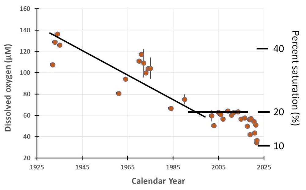
In 2003, a series of measurements revealed that the deep waters of the maritime estuary, close to Rimouski, had very low levels of dissolved oxygen that fell below the threshold value for severe hypoxia (62.5 µmol/L or 20 per cent saturation). Below this threshold, several species of fish, such as cod, cannot survive long, and the structure and activity of benthic communities, such as molluscs and shrimp, that live deep near the bottom, are greatly modified.
Water with even lower concentrations of dissolved oxygen (60 µmol/L, or 18 per cent saturation) lines the bottom of the Laurentian Channel, creating a hypoxic zone that extended over approximately 1,300 square kilometres, from Tadoussac to Pointe-des-Monts.
Historical data paired with data acquired between 2003 and 2021 reveal that dissolved oxygen concentrations in the deep waters of the estuary have been in deep decline over the past century. They were cut in half between 1934 and 1985 (decreasing to 60 µmol/L from 135 µmol/L), and then remained relatively stable until 2010. In 2021, however, the measured concentrations dropped even further to half what it had been just two years earlier (35 µmol/L).
In addition, deep waters with these low oxygen concentrations now extend to the gulf, tripling the area of the hypoxic zone in just 20 years.
What are the causes?
Over the past century, as dissolved oxygen concentrations decreased, deep-water temperatures have also increased dramatically to 6 C from 3 C. Micro-paleontological research — the counting and identification of fossil micro-organisms — and geochemical analyses of sediments collected from the bottom of the Laurentian Channel have also found evidence of these historic changes in temperature and oxygenation. The trend started well before the 20th century.
An analysis of deep-water chemical and physical variables also reveals a change in the relative proportions of waters from the Labrador and Gulf Stream (or North Central Atlantic) currents feeding the Laurentian Channel. The proportion of warm, less-oxygenated waters from the Gulf Stream is increasing, at the expense of colder, more oxygenated waters from the Labrador Current.
Therefore, a smaller contribution from the Labrador Current leads to warmer and less oxygen-rich waters. While in 1930, 72 per cent of deep water in the Laurentian Channel came from the Labrador Current, this proportion has dropped to less than 20 per cent.
A global phenomenon
Deoxygenation of coastal waters is a phenomenon that has been observed on a global scale since the mid-20th century. In 1995, approximately 200 sites were listed. By 2008, this number had more than doubled!
Such a large and rapid change has never been observed for an environmental variable of such great importance in coastal and estuarine marine ecosystems. In most cases, however, the lack of oxygen is temporary. When the water column is shallow and seasonally stratified, as in the Gulf of Mexico, episodes of hypoxia or even anoxia (total absence of dissolved oxygen) do not last all year.
Dissolved oxygen is renewed in the fall or winter, during ventilation events, where the water column is cooled by the atmosphere and the density of the surface water becomes high enough to generate a complete mixing of the water column, and carries oxygen to the bottom.
In the Lower St. Lawrence estuary and the gulf, hypoxia is persistent because the water column is deep and highly stratified throughout the year. The deep waters that migrate from the Atlantic to Tadoussac are isolated from the atmosphere for four to seven years and the dissolved oxygen is gradually consumed throughout the transit.
It remains to be seen whether the warming of the Atlantic Ocean waters will persist, thereby further threatening the ecosystems of the St. Lawrence.
Joannie Cool, who recently completed her master’s degree on oxygen dynamics in the sediments of the St. Lawrence estuary, co-authored this article.