

“Did the Atlantic close and then reopen?” That was the question posed in a 1966 paper by the Canadian geophysicist J. Tuzo Wilson.
The answer? Yes, over millions of years. And it was the breakup of the supercontinent Pangea, starting some 180 million years ago, that began creating the Atlantic Ocean basin as we know it today.
Earth’s surface is made up of intersecting tectonic plates. For much of our planet’s history these plates have been bumping into one another, forming chains of mountains and volcanoes, and then rifting apart, creating oceans.
When Pangea existed it would have been possible to walk from modern Connecticut or Georgia in the U.S. to what is now Morocco in Africa. Geologists don’t know what causes continents to break up, but we know that when rifting occurs, continents thin and pull apart. Magma intrudes into the continental rocks.

This story is part of Oceans 21
Five profiles open our series on the global ocean, delving into ancient Indian Ocean trade networks, Pacific plastic pollution, Arctic light and life, Atlantic fisheries and the Southern Ocean’s impact on global climate. Look out for new articles in the lead up to COP26. Brought to you by The Conversation’s international network.
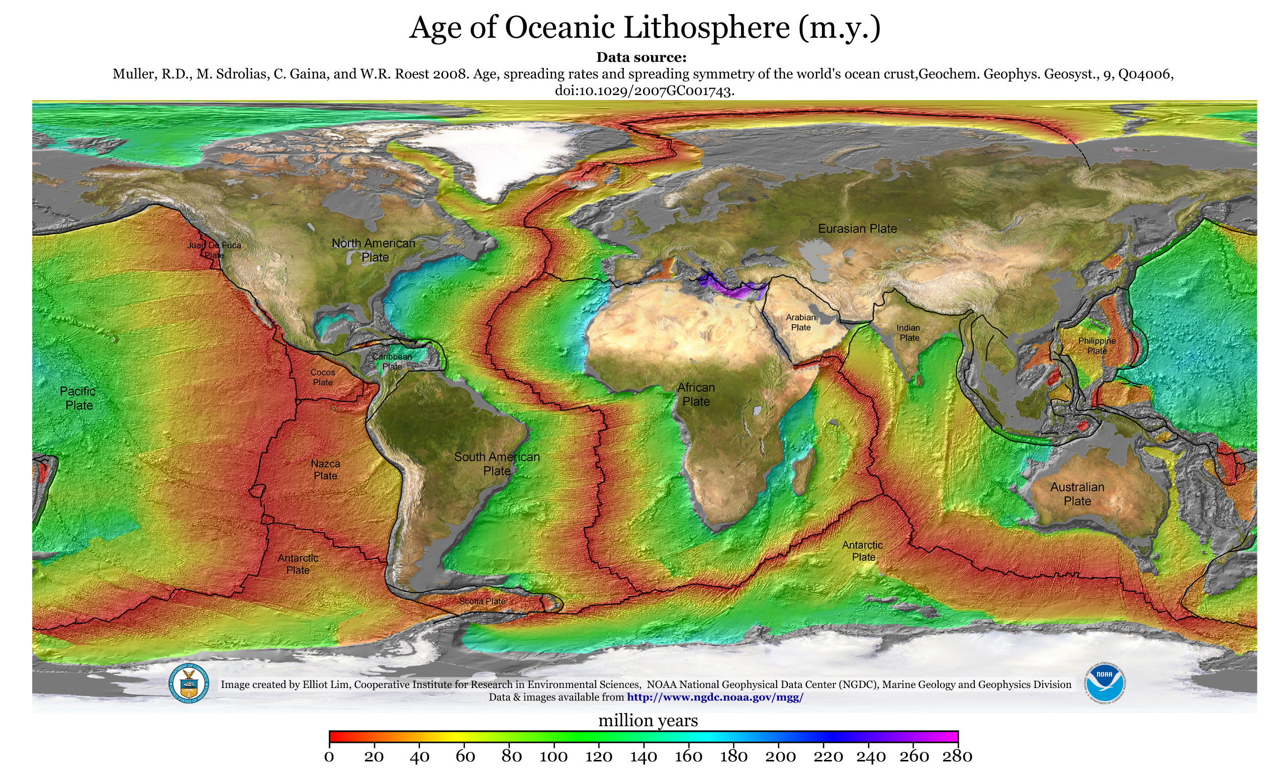
The oldest portions of crust in the Atlantic Ocean lie off of North America and Africa, which were adjacent in Pangea. They show that these two continents separated about 180 million years ago, forming the North Atlantic Ocean basin. The rest of Africa and South America rifted apart about 40 million or 50 million years later, creating what is now the South Atlantic Ocean basin.
Magma wells upward from beneath the ocean floor at the Mid-Atlantic Ridge, creating new crust where the plates move apart. Some of this ocean crust is younger than you or me, and more is being created today. The Atlantic is still growing.

Winds and currents
Once the ocean basin formed after Pangea’s breakup, water entered from rain and rivers. Winds began to move the surface water.
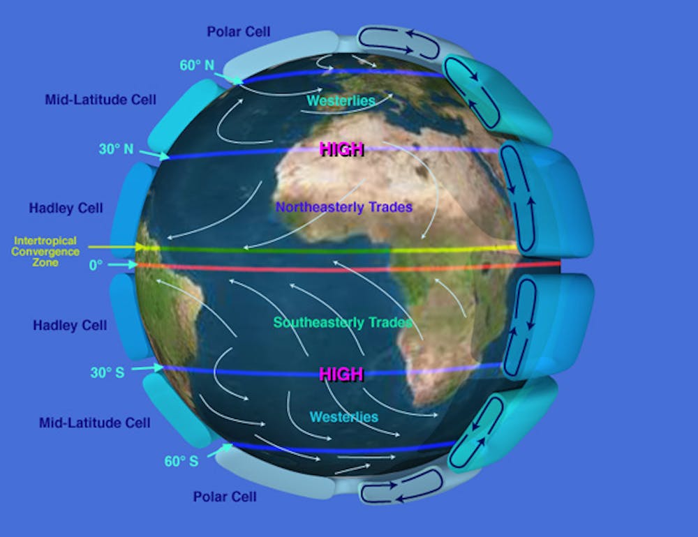
Thanks to the unequal heating of Earth’s surface and its rotation, these winds blow in different directions. The Earth is warmer at the equator than near the poles, which puts air in motion. At the equator the planet’s heat causes moist air to warm, expand and rise. At the polar regions cold, dry, heavier air descends.
This motion creates “cells” of rising and descending air that control global wind patterns. Earth’s rotation dictates that different parts of the globe travel at different speeds. At a pole, a molecule of air would just spin around, while a particle of air at the equator in Quito, Ecuador, would travel 7,918 miles (12,742 kilometers) in a single day.
This different movement causes the air cells to break up. For example, in the Hadley Cell, tropical air, which rose at the equator, cools in the upper atmosphere and descends at about 30 degrees north and south latitude – roughly, near the northern and southern tips of Africa. Earth’s rotation turns this descending air, creating trade winds that flow from east to west across the Atlantic and back to the equator. At higher latitudes in the North and South Atlantic, the same forces create mid-latitude cells with winds that blow from west to east.
As air flows across the ocean’s surface, it moves water. This creates a circulating system of gyres, or rotating currents, that move clockwise in the North Atlantic and counterclockwise in the South Atlantic. These gyres are part of a global conveyor belt that transports and redistributes heat and nutrients throughout the global ocean.
The Gulf Stream, which follows the U.S. East Coast before heading east across the North Atlantic, is part of the North Atlantic gyre. Since the current carries warm water north, it is easy to see on false-color infrared satellite images as it transports heat northward. Like a river, it also meanders.
Moving water masses
These wind-blown surface currents are important for many reasons, including human navigation, but they affect only about 10% of the Atlantic’s volume. Most of the ocean operates in a different system, which is called thermohaline circulation because it is driven by heat (thermo) and salt (saline).
Like many processes in the ocean, salinity is tied to weather and circulation. For example, trade winds blow moist air from the Atlantic across Central America and into the Pacific Ocean, which concentrates salinity in the Atlantic waters left behind. As a result, the Atlantic is slightly saltier than the Pacific.
This extra salinity makes the Atlantic the driving force in ocean circulation. As currents move surface waters poleward, the water cools and becomes more dense. Eventually at high latitudes this cold, salty water sinks to the ocean floor. From there it flows along the bottom and back toward the the opposite pole, creating density-driven currents with names such as North Atlantic Deep Water and Antarctic Bottom Water.
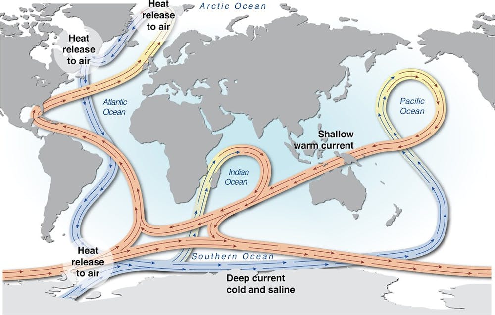
As these deep currents move, they collect surface organisms that have died and fallen to the bottom. With time, the organisms decompose, filling the deep water with essential nutrients.
In some locations this nutrient-rich water rises back up to the surface, a process called upwelling. When it reaches the ocean’s sunlit zone, within 650 feet (200 meters) of the surface, tiny organisms called phytoplankton feed on the nutrients. In turn, they become food for zooplankton and larger organisms higher up the food chain. Some of the the Atlantic’s richest fishing grounds, such as the Grand Banks to the southeast of Newfoundland in Canada and the Falkland/Malvinas Islands in the South Atlantic, are upwelling areas.
Much about the Atlantic remains to be discovered, especially in a changing climate. Will rising carbon dioxide levels and resulting ocean acidification disrupt marine food chains? How will a warmer ocean affect circulation and hurricane intensity? What we do know is that the Atlantic’s winds, currents and sea life are intricately connected, and disrupting them can have far-reaching effects.
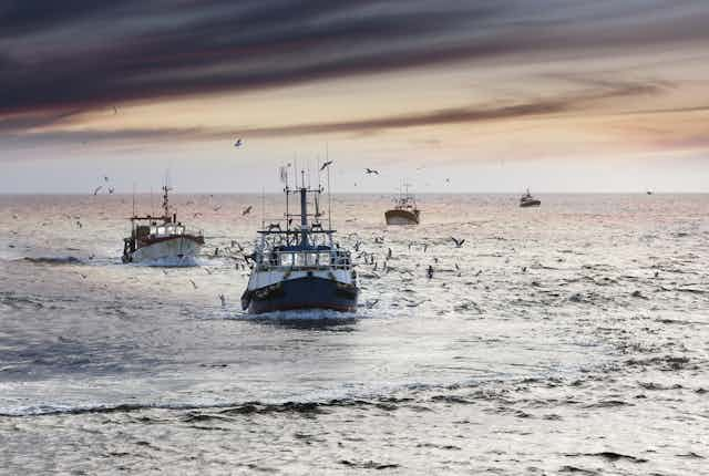
Atlantic cod fishing
Now, let’s head back up to the surface, and into the wake of the first sailboats that set out to fish for cod along the Canadian coast. These pioneering ships paved the way for greater exploitation of the Atlantic’s wealth of fishery resources – particularly cod. Communities of people greatly benefited from these resources over the following centuries, until the threat of overfishing became impossible to ignore.
The history of fishing in the Atlantic is often said to trace back to the discovery of the cod-rich Canadian waters of Newfoundland, attributed to Italian navigator and explorer John Cabot, who led an English expedition there in 1497. From the 16th to the 20th centuries, cod-fishing mania swept European fleets. Between 1960 to 1976, ships from Spain, Portugal and France were responsible for 40% of the catch. However, in 1977 Canada extended its territory offshore by 200 miles, taking possession of the Newfoundland cod fisheries, which accounted for 70% of cod production in the Northwest Atlantic.

For five centuries, the only thing that mattered was the size of the catch. This drove innovations in the design and equipment of fishing boats. The sailboat cod-fishing industry in Newfoundland and Iceland hit its peak in the late 19th century; from 1800 to 1900, France – the main fishing operator alongside Britain – outfitted more than 30,000 schooners.
At the end of the 19th century, the rowboat was replaced by the dory, a small (two-person) boat from North America, which sharply increased production. A plaque commenting on the new safety of the dory in the French Museum of Fisheries, in Normandy – dedicated to the history of commercial cod fishing – noted that the hazard of losing a man overboard was “built into the mindset of cod-fishing.” But by the early 20th century, steamers had begun to replace these boats.
New productivity gains came with new techniques, such as using back-trawling instead of side-trawling in the 1950s and 1960s, alongside reduced crew sizes.
The biggest cod catch, at nearly 1.9 million tons, was recorded in 1968. After that, overall production declined year after year, reaching less than a million tons in 1973. Numbers slowly picked up again in the 1980s after European fleets were excluded from the Newfoundland area, but this comeback was short-lived. On July 2, 1992, the Canadian government announced a moratorium on cod fishing, confirming that populations had collapsed. This collapse in the northwestern Atlantic has since become a textbook example of the risks of overfishing.
The wider catch
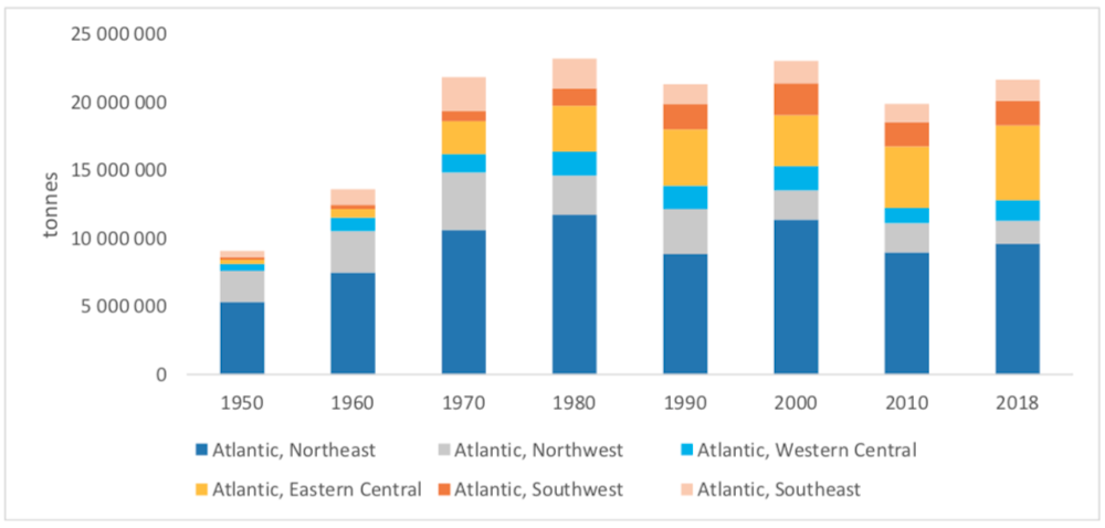
Seafood production in the Atlantic went from an estimated 9 million tons in 1950 to more than 23 million tons in 1980 and 2000, and 22 million tons in 2018. This overall production has remained stable since 1970.
In the North Atlantic, whiting and herring are the two most fished species by tonnage. Sardine and sardinella hold the top spots in the Central Atlantic. In the South Atlantic, mackerel and Argentine hake dominate the catch.
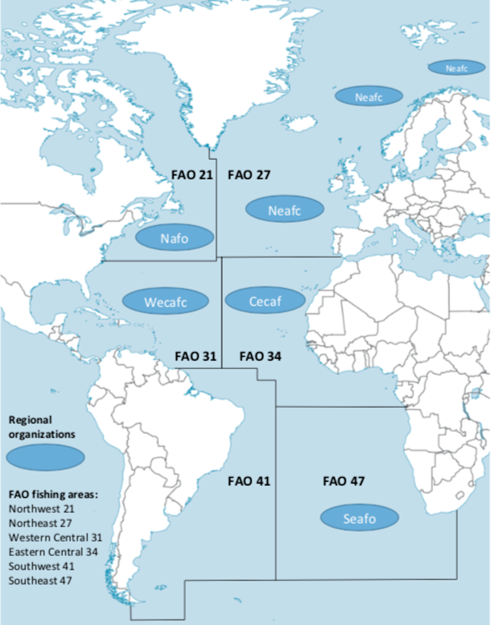
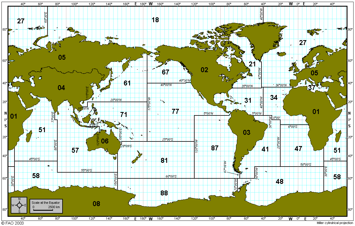
The Food and Agriculture Organization of the United Nations (FAO) has identified six production areas in the Atlantic Ocean, divided up cardinally, as shown on the map below. In 1950, these various areas accounted for 52% of the worldwide catch. From 1960 to 1980, this proportion went down to 37% to 43%. Since 1990, one-quarter of global seafood production is caught by fleets operating in the Atlantic.
Nearly 60% of seafood production now comes from fisheries in the Pacific Ocean, and 15% from the Indian Ocean.
The northeastern Atlantic (FAO Area 27) covers fisheries operated by European fleets. This area is, by far, the most bountiful of the entire Atlantic zone, with a total catch of 9.6 million tons in 2018. Norway took the lead for seafood production by tonnage (2.5 million tons) in 2018, ahead of Spain (just under a million tons). It is also the most diversified zone, with more than 450 commercial species.
The northwestern Atlantic (FAO Area 21) stretches from the Rhode Island and Gulf of Maine coastlines in the U.S. to the Canadian coasts, including the Gulf of Saint Lawrence and the waters of Newfoundland and Labrador. Cod has dominated the history of fishing in this area since the 16th century. The biggest overall catch was recorded in 1970, at more than 4 million tons. But, after 1990, that number dropped, as a consequence of the 1992 moratorium. Since 2000, the northwest area has accounted for around 10% of the Atlantic catch (1.7 million tons in 2018). There are 220 monitored species in the area.
Eastern Central Atlantic (FAO Area 34) stretches from the Moroccan to the Zairian coasts. Species caught include sardine, anchovy and herring. In 2018, this area accounted for a quarter of the total seafood production of all six Atlantic areas. That same year, West African fisheries recorded the second biggest catches after the northeastern Atlantic. The high number of commercial species identified by the FAO sets this region apart, at nearly 300.
Western Central Atlantic (FAO Area 31) stretches from the southern U.S. to the north of Brazil, including the Caribbean. Since 1970, catch size has remained between 1.3 million and 1.8 million tons (5% to 10% of the entire Atlantic catch). Lobster and shrimp are the target species in the Caribbean waters.
Southeast Atlantic (FAO Area 47) connects the African coastlines of Angola, Namibia and South Africa. Production surpassed 2 million tons in 1970 and 1980, accounting for 10% of the total Atlantic catch. Since 1990, the catch has been stable, with a plateau of 1.5 million tons. It’s the least diversified region in the Atlantic, with 160 species monitored by the FAO. Mackerel, hake and anchovy make up 59% of total production.
Southwest Atlantic (FAO Area 41), which stretches along the coastlines of Brazil, Uruguay and Argentina in South America, was the lowest-producing of the six areas until 1980. It recorded no more than 5% of the total Atlantic catch. But from 1990, fisheries produced 1.8 million to 2 million tons (8% to 10% of the overall catch). This can be attributed to investment from the Argentinian government into fishing fleets in the 1980s. Some 225 commercial species are being statistically monitored, with 52% of total production coming from hake, shortfin squid and shrimp.
Protecting the entire ecosystem
At a time when scientific research predicts that all living marine resources will be exhausted by 2048, a new fisheries approach is required to avoid new tragedies, like the one that befell the cod populations in the northwestern Atlantic.
In this context, protecting ecosystems has become a priority. This growing acknowledgment of the impacts of fishing is a direct result of the successful work undertaken by ecological and social science researchers since the 1970s, who placed the concept of resilience at the heart of their studies.
This new ecosystem-based management approach, now inscribed in law in Europe and Canada, has been positive. A similar U.S. policy was revoked by President Donald Trump, but likely will be restored by incoming president Joe Biden. However, there is still work to do to tackle the main challenge – making this approach a reality in all Atlantic fisheries.