Articles on Cartography
Displaying 1 - 20 of 23 articles

Cartography has become one of the most successful technologies for understanding the world around us. But like the world itself, maps and map-making are constantly evolving.

Geographers often talk about the ‘silences’ of maps – what’s missing and unseen. Those silences can be as meaningful as what’s shown.

The Tasman map, dating from the 1600s, was promised to the Commonwealth – but NSW got it instead. Here’s how it happened.

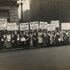
Women’s rights activists used maps to highlight which regions hadn’t given women the vote: we can use the same tactics to push climate action.

In many cases, colonial maps would portray conquered land as having been ‘empty’ and available when settlers arrived — even if it wasn’t.

Boundaries aren’t just treaties. They’ve been built from rivers, oral history and newspaper notices — and rocks in the way of farmers.

Mapping is one way African Americans fight for equality and help each other navigate a racially hostile landscape.

Counties, local authorities, councils – how you divvy up the map changes the game significantly.

Born on July 30, 1920, geologist and cartographer Tharp changed scientific thinking about what lay at the bottom of the ocean – not a featureless flat, but rugged and varied terrain.

Maps shape our understanding of world events like the COVID-19 pandemic. Here’s how to make sure they don’t mislead you.

When mapping deprivation, using traditional boundaries can distort the data and distract readers from important information.

We have the Apollo missions to thank for a lot of our geological knowledge about the moon.

In May 2019, Canada made a partial submission to the United Nations on the limits of its extended continental shelf in the Arctic.

Historically, western corporate maps have been privileged over Indigenous ones. But given the essential debate of territory in resource conflicts, maps are a crucial tool.

Maps can show “the big picture” to lots and lots of people in an engaging and colourful way.

Can happiness really be mapped?

Economists try to create and use maps to navigate the world of human choices. But in some ways, these maps are limited.

They are contesting the maps that deny them territorial rights.

Areas of the brain are being mapped, much like the towns, cities and countries represented in a typical atlas.

Nothing is where you think it is.
