By detailing the landscape at the time of first humans’ migration into Australia, we can better understand how people travelled and where they settled.
Experts say the ‘reimagining’ of the South Australian Museum will destroy its crucial contributions to science.
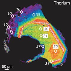
This image of a single crystal shows 30 million years of geological history of the Himalayas by tracing its thorium concentration and age.
Matthew J. Kohn
Scientists Jan Zalasiewica and Erle Ellis on the recent decision to reject a proposal for a new geological epoch, the Anthropocene. Listen to The Conversation Weekly podcast.
Geologists recently voted down a proposal to formally recognise the Anthropocene.
The Barberton Makhonjwa Mountains look peaceful today - but 3.5 billion years ago the earth there was roiled by volcanoes.
Instinctively RDH/Shutterstock
While NASA rovers on the surface of Mars look for hints of life, researchers back on Earth are studying ‘echoes of life’ from ancient basins – hoping that the two sites might be similar.
Mining the moon for its resources is growing more and more likely.
(Shutterstock)
At Q’s of course! But he doesn’t pull them out of his sleeve. In Spectre (2015), Daniel Craig and Ben Whishaw play the famous spy and his gadget supplier.
Our new study reveals a mosaic of habitable landscapes – now submerged by the ocean – once supported up to 500,000 people living in Australia’s northwest.
For decades, scientists have tried to uncover the cause of long-term changes in Earth’s biodiversity. New simulations point at geography playing a critical role.
Two crystalline materials together: kyanite (blue) embedded in quartz (white).
Photo 12/Universal Images Group via Getty Images
There are a lot of myths about crystals − for example, that they are magical rocks with healing powers. An earth scientist explains some of their amazing true science.
A distant lump of space rock may have a surprising amount in common with the core of our own planet.
Perspective view of a lobate scarp on Mercury named Carnegie Rupes, colour-coded according to surface altitude. The crater near the middle is nearly 40 km across.
NASA/Johns Hopkins University Applied Physics Laboratory/Carnegie Institution of Washington