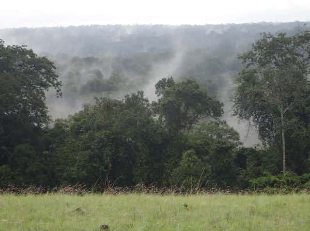


“Green lungs” is the term often used to describe rainforests due to their ability to use photosynthesis to capture CO2, the planet’s primary greenhouse gas. That makes them a key component of global climate regulation, and their preservation represents a major issue for decision-makers and citizens alike. But calculating how much carbon such forests store and the flows they represent into the planet’s overall greenhouse gas balance is no easy feat. In fact, it is one of the segments where our knowledge remains most limited - even the carbon stocks and flows of the oceans are easier to quantify.
The stakes are colossal, however. To prevent future scandals around conserving ecosystems that are reputed to be carbon sinks, we need reliable, independent measuring and monitoring systems. Otherwise, each country and stakeholder can take all the credit for themselves, come up with definitions and measurements that best suit their interests, and pay no heed to reality or the evolution of forest ecosystems.
Forest carbon stocks are not a cryptocurrency; they are a tangible physical quantity, but one that proves tricky to measure.
So how has this been done until now, and how have people gone about measuring these carbon stocks and flows that spark such fervent - and at times opportunistic - interest?
The forest inventory
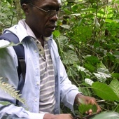
It all starts in the forest with the tried and tested methods of the woodcutter, as used by the forest industry to compute volumes of harvestable timber. Because carbon makes up half of the total dry mass of green plants, specifically trees, quantifying the total stock of this element means coming up with an estimate for the volume of each tree and identifying its species. The species is important because this is what helps determine wood density and, ultimately, the amount of carbon stocked per volume of wood.
Obviously, the number of species found in one rainforest can be so huge that not a single expert in the world could name every one of them. While temperate Europe contains only 124 tree species, there are at least 40,000 growing in the tropics, with some estimates putting this number at more than 53,000. As such, researchers must systematically compile plant collections to serve as benchmark test material, checking whether a tree belongs to a given species by looking at existing samples from museums and universities.
Next, to assess the evolving carbon stock – which is to say the carbon flowing in and out of the forest – measurements must be taken regularly to calculate tree growth, count dead specimens and include shrubs that are tall enough to be categorised as trees.
Forest inventory

To make the challenge even more daunting, tropical forests are - still - vast, dense, difficult to access and located in countries with poor infrastructure. Even when all goes well, the site to be inventoried will require at least several days’ travel from the capital. Of course, it would be impossible to measure the whole forest; instead, a sample is taken, just like for an electoral survey. Typically, researchers select a number of fairly large tracts of land (ideally equivalent to the size of two football pitches, i.e., between 500 and 1,000 trees per tract).
The selection criteria constitute a whole science in themselves (whether the sample is totally random or chosen from among specific vegetation types), and modifying the criteria halfway through the process can render the entire task null and void. Researchers speak of “majestic forest” bias, for instance, when tracts are selected in unusually intact forests to estimate the average carbon content for all the forests in a given region.
Simple measurements are taken on site, including trunk diameter and, more rarely, tree height. Next, researchers draw up conversion tables known as allometric equations, which use these few measurements to estimate how much carbon a tree contains. The equations are created through felling and weighing a small number of trees. Given that the wet mass of just one of these giants can reach up to 160 tons and that it must be weighed directly in the forest, it can take a dozen workers a whole week to weigh a single tree.

Consequently, it is common to use equations from other regions, which can lead to bias. There are alternatives being developed that do not harm the forest, such as laser scanners, which can now measure the precise volume of standing trees. These methods have helped us produce new allometric equations in Cameroon and the Democratic Republic of Congo, both much more efficiently and without compromising on accuracy.
This article is brought to you in partnership with “Your Planet”, an AFP audio podcast. A creation to explore initiatives in favour of ecological transition, all over the planet. Subscribe
How can this be applied on a large scale?
Even with sampling, there are still considerable challenges involved in remeasuring sites to obtain reliable, up-to-date estimates of the carbon stocks and fluxes of an entire country or of all rainforests. Recent decades have seen the development of remote measuring techniques (known as remote sensing) for more efficient sampling that is less vulnerable to unpredictable conditions on the ground. Satellites scan the globe, taking daily measurements to measure surface status changes, rainfall and water currents, among other values.
Space missions have been set up specially to measure forest biomass, such as ESA’s BIOMASS mission, which is currently awaiting a reliable launcher for take-off, or the GEDI laser on the International Space Station. In the meantime, we will have to keep extrapolating data from existing satellites, which are not necessarily designed for inspecting dense forest canopies.

This is because remote sensing does not measure carbon or biomass directly, but rather a quantity of light or radio waves reflected by the objects in question. Complex physical or statistical models must be established to convert the raw data into actionable information, which is why it is vital to gather field data. Due to the scarce data and limited satellite signals currently at our disposal, the average for a country can almost double from one map to the next. Over the last decade, our team has spent many hours analysing the sources of these errors, which are sometimes hidden behind poor statistical approaches or poorly recorded instrumental effects.
For instance, images cannot be compared directly if they are taken in varying light conditions or atmospheres. Due to the permanent cloud cover near the Equator, we can even be constrained to using very poor-quality images or pixel composites amassed from a variety of images.
However, it is not enough to design supercomputers and launch space missions. Reinvesting in data acquisition on the ground is also vital in order to provide essential reference information. International initiatives are being devised to support national forest inventories (as seen above) or set up state-of-the-art calibration sites to serve as a reference for satellite missions.

What about other segments?
If assessing carbon stocks in the visible parts of standing trees is difficult enough, very little is known about these trees’ roots and the carbon contained in soil, or about the amount that is carried away by rivers or absorbed into the atmosphere. For example, the peat bogs of the Congo basin were recently found to contain more carbon than all the forests in that same region.
To measure the overall respiration and photosynthesis of the planet’s famed “green lungs”, we must erect flux towers. Looking out over the tree canopy at around 60 metres in height (and sometimes more than 300), these structures are fitted with devices with names like “sonic anemometer,” “infrared CO2 analyser” and “hygrometer”, that measure gas exchanges between the atmosphere and the forest. It is a challenge in and of itself to power, maintain and secure such a facility over several decades. A team of fellow researchers attempted this feat in the Congo in the 1990s. When they returned, the tower’s aluminium cladding had been melted down and used to make pots.
Few realise that, in spite of the climate crisis, there is basically no measuring infrastructure left in good working order in Africa. There is even a shortage of basic facilities, such as weather stations. This dearth of material prompts some deeper questions: who should be tasked with gathering all the essential data – government bodies in the Global South, private industrial operators, research agencies in the Global North? For our part, we advocate collaboration between researchers and scientific institutions from both of these regions, as this would enable us to learn together by benefiting from the best technology available.
What is the end goal?
Science is doing its best to make more pertinent measurements of rainforest carbon stocks and fluxes. In time, this should help avoid repeating errors, whether careless or deliberate, such as those from Malaysia, which made global headlines in 2021, when the country’s annual greenhouse gas balance claimed an annual forest carbon sink of over 243 million tons – equal to the amount in neighbouring Indonesia, which has five times as much forest land.
But while some countries publish exaggerated figures, others do not even bother. With some researchers already worried that we will have exceeded the 1.5°C limit set by the Paris Agreement by the end of 2023, the lack of data around greenhouse gas fluxes, stocks and emissions remains particularly alarming. At the start of the year, only 48 countries had published an inventory of their greenhouse gases. This is tiny when we consider the fact that, starting in 2024, the 197 member countries of the United Nations Framework Convention on Climate Change will be obliged to submit an annual report on this topic.
Rigorous measurements of carbon fluxes and stocks are also crucial to assessing the impact of conservation projects in forest ecosystems. Such measurements are especially important in the case of monetisation using carbon credits, as is the case for projects to avoid deforestation or promote reforestation. Once again, we must avoid falling into the same traps of recent decades, which have seen many forest conservation projects fail to produce any real, positive impact.
This article is part of a project between The Conversation France and AFP Audio, supported financially by the European Journalism Centre, as part of the Bill and Melinda Gates Foundation “Solutions Journalism Accelerator” “Solutions Journalism Accelerator” initiative. AFP and The Conversation France have maintained their editorial independence at every stage of the project.