AAP Image/Supplied by the Department of Defence
Weather forecasting is improving at a great rate, even though climate change could be making it tougher.
Road collapse in northern Kenya due to flash floods on 22 November 2023.
Photo by Luis Tato/AFP via Getty Images
Projections show that there’ll be Indian Ocean dipoles in the future – and that means more rainy days, and more extreme rainfall.
Hurricane Otis gave Acapulco almost no time to prepare.
Xinhua / Alamy
A deadly hurricane developed in just 12 hours.
The Royal Charter was shipwrecked at Porth Alerth near Moelfre on Anglesey.
John Oxley Library, State Library of Queensland
More than 800 lives were lost in the Royal Charter storm but it also led to improvements in weather forecasting.
Tidal surges can cause enormous damage.
Martha van der Westhuizen/500px
Local communities need to be warned more clearly and effectively if there is a threat of a storm surge and of coastal flooding.
Extreme heat can put lives at risk, making accurate forecasts essential for people working outdoors.
FG Trade/E+ via Getty Images
Three economists looked at years of temperature and death data and calculated the costs when forecasts miss the mark.
A natural weather event known as El Niño is underway in the Pacific Ocean.
jon sullivan/Shutterstock
An El Niño weather-warming phase is underway in the Pacific – but what does this mean for the weather in Europe?
Jeff McIntosh/AP/Canadian Press
The 2021 Pacific Northwest heatwave outstripped even the most severe climate prections. A new study simulated 45,000 years of weather at Seattle Tacoma airport to try and figure out why.
Potentially dangerous air turbulence has increased on busy flight routes across the globe.
Jaromir Chalabala/Shutterstock
Turbulence strong enough to pose an injury risk could be set to double or triple in frequency in the future.
A flash drought in 2012 dried out soil, harming crops in Kansas and several other states.
John Moore/Getty Images
If greenhouse gas emissions continue at a high rate, breadbaskets of Europe and North America will see a 50% chance of a flash drought each year by the end of this century.
Forecasting, risk plans and effective drainage systems can mitigate the impact of severe floods.
Photo by Pius Utomi Ekpei/AFP via Getty Images.
Getty Images
Nigeria is expected to experience severe flooding this year. With proper planning and management its impact may not be so devastating.
Fire at the University of Cape Town, South Africa.
Photo by Brenton Geach/Gallo Images via Getty Images
Autumn extreme fire weather around Cape Town in South Africa has become 90% more likely in a warmer world.
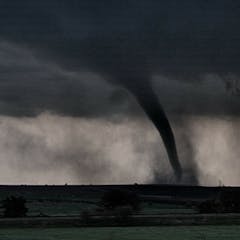
A tornado touches down.
Morgan Schneider/OU CIMMS/NOAA NSSL
Researchers are turning to computer models, drones and other methods to improve tornado forecasting.
Sandhill cranes flying above the Platte River in Nebraska.
shannonpatrick17/Flickr
Machine learning may not seem to have much connection with wildlife, but it’s starting to play a central role in bird conservation.
Dean Lewins/AAP
Not all La Niñas are wet, nor El Niños dry – especially if you live in Sydney. So here’s how to interpret what an El Niño forecast means for you.
Following historic drought in 2021, reservoir levels dropped down in the Hoover Dam on the Colorado River, which gets its waters from the melting snowpack from the Rocky Mountains of Colorado and Wyoming.
(pxhere.com)
Unprecedented droughts leave the subsurface drier than usual, affecting water supply in subsequent years.
As of June 20, 2023, 64% of the U.S. corn crop faced moderate or more intense drought.
Jim Watson/AFP/GettyImages
Flash droughts can develop within a few weeks, causing water shortages, damaging crops and worsening fire risks.
Muhammad Qadri Anwar/Shutterstock
High humidity, terrain and wind make rain forecasting particularly tricky in the tropics.
Neil Hall/EPA
The Met Office issued its heatwave warning six days before the mercury peaked – potentially saving many lives.
Meteorologist Todd Dankers monitors weather patterns in Boulder, Colorado, Oct. 24, 2018.
Hyoung Chang/The Denver Post via Getty Images
Would you trust a weather forecast made by a machine that had learned how weather systems behaved by reviewing thousands of past weather maps?